Mid Coast Saturday morning, South from Tuesday

South Australian Forecast (issued Friday 24th April)
Best Days: Saturday morning on the Mid, Tuesday, Wednesday and Thursday mornings down South,
Recap
Yesterday was fun across the South Coast through the morning with a building new swell and light variable winds. Afternoon sea breezes added a few bumps into the afternoon though. The Mid Coast was tiny but kicked to a better 1ft with light variable winds into the afternoon, creating ideal conditions for beginners.
Today the swell was a good 3-4ft across the Middleton stretch and bigger bombs at Waits with early offshores but a strong onshore change has since moved through. This should swing back to the W/NW through the afternoon though, so give it a couple of hours.
The Mid Coast was a sloppy 1-2ft but should kick to a stormy 2-3ft across this afternoon with strengthening W/NW winds.
 This weekend (Apr 25 – 26)
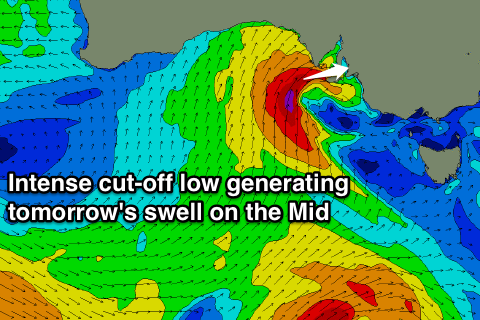
Currently a deepening cut-off low is positioned to our west and this will push in and across us this evening, aiming a fetch of severe-gale SW winds into the Mid Coast kicking up a solid 3ft of swell tomorrow morning that will then ease through the day.
The South Coast should see a mix of SW and building S'ly swell from a fetch of strong S'ly winds being projected up into the coast through the day but conditions will be poor with a strengthening S'ly breeze.
The Mid Coast is looking peaky and fun as the low moves across us, swinging winds S/SE through the morning before tending more S/SW through the day.
Sunday won't be any better down South with plenty of swell but a persistent and fresh S/SW'ly.
The Mid Coast should be easing from the 1-1.5ft range but less than perfect with a S'ly tending S/SW wind.
Monday onwards (Apr 27 onwards)
Monday will be another lay day with tiny waves on the Mid Coast and onshore S/SW winds down South.
A new S/SW groundswell is due to build through the day though and then ease through Tuesday and Wednesday as conditions finally improve.
This swell will be generated by a relatively weak polar front firing up to the south-west of WA today and projecting north-east towards Victoria, generating a moderate sized S/SW groundswell for later Monday and Tuesday morning.
Middleton should ease from 3-4ft at Middleton with 4-5ft sets at Waits, down further from 2-3ft at Middleton Wednesday and 3-4ft at Waits.
Winds should swing light E/NE through the morning with better NE winds Wednesday, while Thursday looks the straightest with a better N'ly breeze but small swell.
Longer term there's nothing too major on the cards until later into the first week of May, but we'll have a closer look at this on Monday. Have a great weekend!
Comments
Nice double rainbow off the Knights cam this afternoon!