Fun Thursday morning, peaky Sunday

South Australian Forecast (issued Wednesday 7th January)
Best Days: Thursday morning down South, Sunday in protected locations for peaky waves down South, Monday morning down South
Recap
Poor conditions yesterday down South with a moderate to fresh onshore wind already up at dawn, while the Mid Coast was clean but tiny.
Today winds swung offshore down South and continued to strengthen from the NW into this afternoon with a new swell kicking to 2-3ft along the Middleton stretch, with bigger sets at Waits and Parsons. The Mid Coast offered tiny 0.5-1ft sets and we should see it building to 1-1.5ft this afternoon as winds hopefully tend variable.
This week and weekend (Jan 8 - 11)
Today's increase in SW groundswell will peak this afternoon and then drop back through tomorrow from 2ft+ across the Middleton stretch and 3ft+ at Waits with 1ft sets on the Mid.
Winds should be favourable for both coasts during the morning and variable (tending light NW down South) but you'll have to get in before lunch as a fresh and gusty S'ly change is due early afternoon.
This will write-off the surf into Friday with small to tiny leftover amounts of swell and gusty onshore S/SE winds.
Into the weekend the forecast is still moving around but it looks like Sunday could offer some really fun peaky waves.
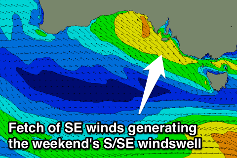 Saturday will be very poor as a couple of deepening inland surface troughs drift towards the coast, squeezing a strong high to our south-west and aiming a fetch of strong SE winds into the South Coast.
This should kick up moderate levels of S/SE windswell to 3-5ft later in the day along with strong and poor S/SE winds.
The trough should move offshore Sunday and with this winds should swing around to the E/NE while also bringing torrential rain, cleaning up the easing S/SE windswell with peaky 3-4ft waves due from Middleton to Parsons.
Protected locations out of the wind will be best, with Goolwa being better but smaller than Middleton.
The Mid Coast isn't expected to see much size with a small kick in SW groundswell Saturday afternoon and Sunday morning to 0.5ft or so.
Next Monday onwards (Jan 12 onwards)
With the trough and high dominating our swell window through the end of this week and weekend, it will also deflect any major frontal and swell activity away from us. Therefore the outlook for early to mid next week isn't good at all.
We may see some good W/SW swell for the Mid into Tuesday if the trough supports the formation of a low in the Bight, but more on this Friday.
Comments
Beautiful