Fun weekend, poor next week

South Australian Forecast (issued Friday 19th December)
Best Days: Saturday morning and early Sunday down South, Monday mid-late morning for keen surfers
Recap
The Mid Coast started off in the small and sloppy 1-1.5ft range yesterday but built to a semi-stormy 2ft+ through the afternoon offering waves across most breaks. The South Coast was OK in protected locations before a strong SW change moved through.
Today the Mid was a lot cleaner but a little unorganised with a light offshore breeze and good 2ft of swell still on the sets.
The South Coast offered plenty of size to 3-4ft at Middleton and 4-5ft at Waits and conditions were a lot better than yesterday with a light to moderate onshore wind.
This weekend (Dec 20 - 21)
Today's increase in swell across both coasts should ease off later today and more noticeably over the weekend as winds try their hardest to swing offshore across the South Coast.
Tomorrow should be clean and peaky but not perfect under a morning E/NE tending NE winds before afternoon sea breezes kick in. Middlton should ease from 2-3ft with 3-4ft+ sets at Waits, while the Mid should drop from 1ft+.
Sunday will be small and easing from 2ft at Middleton and 2-3ft at Waits but under better N/NE winds from dawn to mid-morning before a gusty S/SE change kicks in. Therefore go the early surf for the best of it.
 Next Monday onwards (December 22 onwards)
Next week is looking very average surf wise for the South Coast with Monday being the only real opportunity for a decent wave.
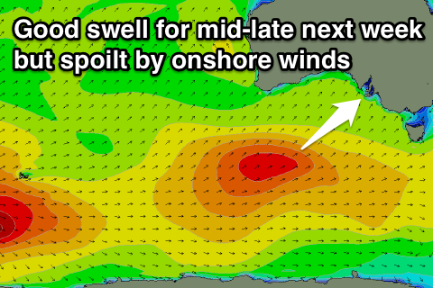
What we'll see is a strong and blocking high developing to our west, with the eastern flank of the high sitting right over us from Tuesday through Friday. With this fresh to strong S/SE winds will kick in Tuesday and Wednesday before shifting more S/SW into Thursday and Friday. Some good pulses of SW groundswell are due through the week as well from Tuesday through Friday but it'll be a total mess with the onshores, and there'll also be junky levels of S'ly windswell in the mix.
Desperate surfers will find some respite Monday morning. Initially conditions will start off poor with fresh E/SE winds, but a swing to light NE breezes is due through the day as a small SW groundswell fills in. Nothing special will be offer with peaky 3ft sets at Parsons mid-late morning for keen surfers.
Now, the Mid Coast should see tiny lines of swell through the whole week, but the most size is due later Wednesday and Thursday, when winds are supposed to go onshore from the S/SW. There's a chance for an early S/SE'ly Thursday morning but the swell is only expected to be in the 1-1.5ft range in any case.
Longer term we're looking at some better polar frontal activity into next weekend and the following week with what appears to be better winds from the W/NW to SW. More on this Monday though. Have a great weekend!