Fun period ahead, S'ly swells next weekend

Nias, Mentawai, South Sumatra forecast by Craig Brokensha (issued Thursday 21st Mayl)
Best Days: Every day over the coming period
This week and next week (May 22 – 29)
Smaller surf into today with a S/SE breeze, but into tomorrow, a new acute S'ly groundswell is due to boost wave heights across exposed south facing breaks.
This swell was generated on the edge of our swell window to the south-southwest of WA and should provide very inconsistent 4-5ft+ waves across exposed breaks during the morning before easing into the afternoon and further Saturday. Weak S/SE breezes tomorrow should become variable into Saturday and remain light in nature from the S/SE for the rest of the period.
Our long-range and inconsistent SW groundswell due to build through Sunday and peak Monday is still on track, with it being produced to the south of South Africa over the weekend.
Exposed breaks should build to an infrequent 3-5ft across the Ments late in the day before peaking Monday to 4-5ft+. A drop in size is then due Tuesday.
A good pulse of S/SW groundswell is then due into Wednesday, generated by a strong frontal progression firing up west of Heard Island today, with a fetch of gale to severe-gale W/SW winds being projected towards Western Australia.
Some moderate sized S/SW groundswell is due off this system for our region, building to 5-6ft across exposed breaks during the afternoon before easing into Thursday and further Friday.
Into next weekend, a large S/SW groundswell due for Eastern Indonesia, generated south-southwest of WA, will be again just on the edge of our swell window, with it due to peak Sunday to an infrequent 4-5ft across exposed breaks in the Ments, with more size around South Sumatra.
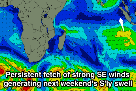
More noticeable around the Ments though will be a funky S'ly trade-swell across south and south-east facing beaks.
This will be generated by a strong and stationary high pressure system to the south of Sumatra, producing a broad and persistent fetch of strong SE winds.
This will generate a moderate sized SE swell for the Maldives, but the Ments should see some S'ly swell spreading out radially into exposed breaks from Friday afternoon, persisting all weekend and then easing back from Monday. Size wise a peak is due on the weekend to 3-5ft or so.
Longer term some better SW groundswell is on the cards for the following weekend (6/7th June) but we'll discuss this more on Tuesday.
16 day Mentawai forecast graph
16 day Nias forecast graph
16 day South Sumatra forecast graph