Plenty of swell into the end of the month

Nias, Mentawai, South Sumatra forecast by Craig Brokensha (issued Tue 16th Sept)
Best Days: Every day over the coming period (smallest Saturday)
This week (Sep 17 - 19)
Our recent large S/SW groundswell has eased over the past couple of days and we'll continue on this trend into tomorrow ahead of a late arriving and secondary pulse of large long-period S/SW groundswell.
This S/SW groundswell was generated by another vigorous polar low similar to the system that generated the last couple of days swell, although it was a touch smaller and shorter-lived resulting in the size being a touch under.
Exposed spots in the Ments should pulse strongly late Wednesday to 6ft+ with 8ft sets in South Sumatra before easing from the 6ft range Thursday and further into the weekend, bottoming out Saturday.
Winds should be generally favourable with weak SE-S'ly winds for the most part around the Ments and strong but easing SE trades in South Sumatra.
This weekend onwards (Sep 20 onwards)
After the swell bottoms out Saturday we should see a new long-range and very inconsistent S/SW groundswell filling in Sunday. This swell was generated by an unfavourably tracking polar frontal progression in the Heard Island region and is only expected to offer infrequent 4-5ft+ waves at exposed spots in the Ments, with 6ft sets around South Sumatra.
The swell should hold into Monday morning before easing through the day.
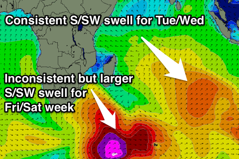 Of much greater importance is a couple of large S/SW groundswells due on Tuesday/Wednesday and then later Friday/Saturday across the region, all owing to a couple of strong nodes (peaks) of the Long Wave Trough moving through the Southern Indian Ocean.
An initial amplification of the LWT moving through over the coming days before weakening through the weekend should project a polar front north into the Central Indian Ocean towards us, generating a consistent S/SW groundswell for Tuesday and Wednesday.
The core winds aren't anything special so we're probably looking at exposed spots reaching 6ft to occasionally 8ft Tuesday afternoon before easing from a similar size Wednesday around the Ments, while South Sumatra will see more size towards that 8ft range.
Of greater importance is a secondary large long-period S/SW groundswell due later Friday, generated by a monster polar low firing up south-east of South Africa, aiming a broad fetch of severe-gale to storm-force W/SW winds towards Eastern Indonesia.
The large distance between the source of the swell and our coasts will result in a lot of swell decay and loss in consistency, but we should still see a very large and powerful S/SW groundswell arriving strongly Friday the 26th and peaking Saturday morning the 17th.
At this stage the size looks to be in the inconsistent 8ft+ range, but we'll review this Thursday.
16 day Mentawai forecast graph
16 day Nias forecast graph
16 day South Sumatra forecast graph
Comments
Certainly a major about face in the forecasts compared to a few days ago for that Fri/Sat 26th/27th!!!
That far out it's always going to shift around until it starts solidifying and then holding with the outlook :)
Shift around!!! It went from 2ft to 6-8ft in one model run!!!!
And the 2ft forecast had been holding fairly true for a few days before that too.
Haha, wow, I haven't been following the specifics of the numbers.
With everything in place ie LWT position and strength there was nearly always going to be something developing after the 22/23rd swell, and now with both ECMWF and GFS showing that real deep low, we're on!
PS, this is the same swell I mentioned yesterday in Stu's second article and the WA notes, so been around for a day or so on the models.
Yep it's been around for a day or so but before that it wasn't showing anything!!!
Looks like the storm generating Tuesday/Wednesday's swell has consolidated a little more while at the same time downgrading the seconday pulse.
Yeah who the feck pissed Huey off!!! :(