Indonesia/Maldives forecast Oct 10

Indian Ocean Basin analysis by Craig Brokensha (issued Thursday 10th October)
This week through next (Oct 11 - 18)
The surf is easing across the region but this will take a change in direction tomorrow as we see the first pulse of large SW groundswell building through the day, peaking into the late afternoon/Saturday morning.
This will then be followed by a secondary pulse of less consistent, slightly smaller and more southerly S/SW groundswell later Saturday and into Sunday morning.
The source of these groundswells was a great frontal progression across the southern Indian Ocean over the weekend and to the south-west of Western Australia this week.
The swell has come in strong across Western Australia and we can expect quality waves from later Friday through the weekend, easing into early next week.
This easing trend will be slowed by reinforcing levels of background S/SW and SW groundswell Monday and Tuesday respectively.
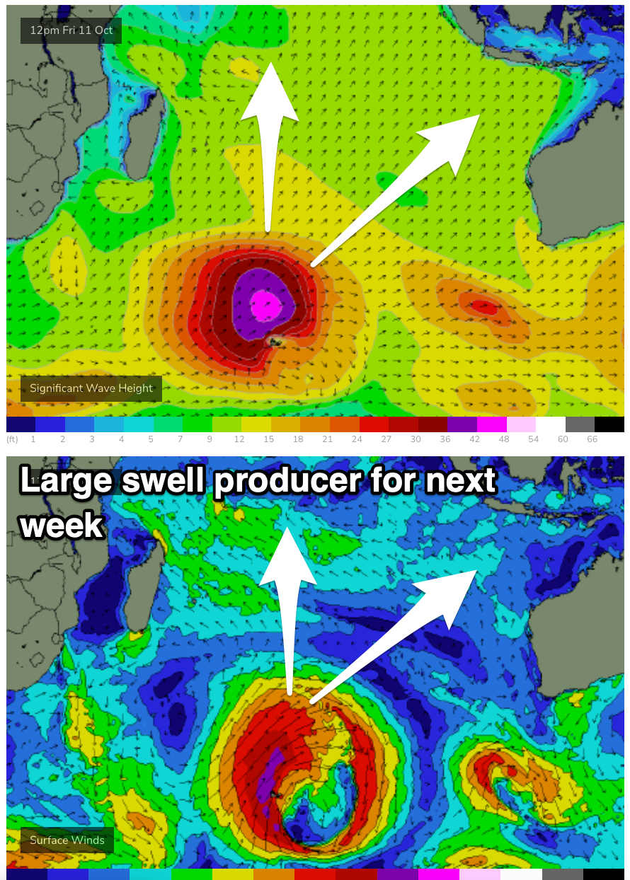
We then look at the significant low currently firing up in the Southern Ocean, with it forming last night to the south-east of South Africa.
A great fetch of storm-force SW winds will be generated from today through tomorrow, with the low only weakening slightly while projecting slowly east-northeast towards Western Australia.
This will see a large, long-period and quite significant SW groundswell generated, with it due to arrive Wednesday, building strongly through the afternoon and then peaking overnight/Thursday morning.
This looks to be one of the most significant swells in months, with plenty more large, reinforcing energy to follow. More on this Tuesday.
----------------------------------------------
Maldives: We should be seeing large levels of S’ly groundswell across the southern atolls today, with it due to ease back through tomorrow as building levels of SE trade-swell due to arrive through the day, peaking through the weekend.
The source of the trade-swell has reached maturity and will slowly weaken and become more patchy from the weekend.
This will result in the energy slowly easing through next week, tailing away slowly into the end of the week but likely not dropping below 2-3ft.
The significant low firing up to the south-east of South Africa should also generate a large, powerful S’ly groundswell for the region Tuesday, tailing away slowly through Wednesday, further into the end of the week.
Winds are strengthening out of the W across the region as a tropical depression deepens to our south, weakening a touch and tending more SW through next week.
Eastern Indonesia:
Large sized SW groundswell building tomorrow, reaching 6-8ft into the late afternoon, holding Saturday morning.
Less consistent, reinforcing S/SW groundswell for later Saturday/Sunday morning to 6ft to possibly 8ft across exposed breaks, easing.
Smaller, reinforcing S/SW and SW groundswells Monday/Tuesday.
Large, strong, long-period SW groundswell building next Wednesday, peaking overnight/Thursday morning, reaching 10ft+ across exposed breaks at is peak.
Swell slowly ease into the end of the week with strong, reinforcing energy for next weekend.
Moderate E/SE-SE trades, variable offshore winds each morning. Winds tending lighter S/SE-S next week.
Uluwatu 16-day Forecast Graph/WAMs
Western Indonesia/Mentawais/South Sumatra:
Large sized S/SW groundswell building later today, peaking tomorrow afternoon to 6ft to occasionally 8ft, easing from a slightly smaller size Saturday, further into Sunday.
Large, powerful S/SW groundswell for Wednesday next week, reaching 10ft across exposed breaks during the day, easing slowly Thursday.
Variable winds, tending mod-fresh NW across northern locations on the weekend.
Mentawai 16-day Forecast Graph/WAMs
Maldives:
Large S’ly groundswell today to 6ft+ across the southern atolls, easing slowly tomorrow.
Moderate sized SE trade-swell building tomorrow, reaching 4ft+ through the weekend, easing very slowly through next week.
Large S’ly groundswell building Tuesday, reaching 6-8ft across the southern atolls into the afternoon (smaller Male), easing slowly Wednesday.
Strong W’ly winds, easing a touch and tending more SW early next week, W/NW later week.
Comments
Latest notes are live.
When would be the best time to shoot over to Lembongan from the 14th onwards? Haven't been over there and hoping there is a bit of action over the next few weeks!
You’re going to get action anywhere you go with this forecast.
BTW Craig, your forcast for the last couple of weeks over there were spot on. I was over in Supa's neck of the woods for several days and scored nicely. Last Saturday had some juice. Cheers.
Cheers Fitz!
Ok indo brains trust. Re west sumbawa
Are there any nooks and crannies for mere mortals to hide out of the large swells inbound next week.
There's quiet a few in West Sumbawa and majority of them are in the Scar reef area and north. Just need good accommodation or someone in the area willing to let you know where they are and what tides the work. Thursday morning for sure be proper epic.
Thanks Hamm
@Craig , not sure if you saw my question on the last swell . I understand you’re busy with family and work . My question was that your notes were spot on for eastern Indonesia at 6-8’ with 10’ cleanups but the models for the region I was in had it at 5ft , why such a difference ?
I think the Wave Watch model didn't resolve that storm very well, hence not showing the size. Interesting one.
Heading to Sumba tomorrow - a little undergunned, I see!
Enjoy @ the-u-turn , gonna be pumping on the 17th .