Indonesia/Maldives forecast June 6

Indian Ocean Basin analysis by Craig Brokensha (issued Thursday 6th June)
This week through next (June 7 - 14)
It’s been non-stop pumping across the Indonesian islands since the start of the week with large back to back pulses of groundswell, initially from the SW and then backed up from the S/SW.
Today things are now on the decline but it won’t be long before the next episode of large swell fills in.
We’ve got another strong progression of high riding storms up into the Indian Ocean, with back to back pulses of large surf due, with an oversized and long-lived number for next week.
Firstly looking at tomorrow and the weekend, some good, large, long-period SW energy is due to fill in, generated by a great Southern Ocean frontal progression from the south-east of South Africa, through the southern Indian Ocean since the weekend.
We should see large sets building back into Friday afternoon/evening, peaking Saturday and then easing slowly into Sunday, though slowed by a reinforcing pulse of S/SW swell in the morning.
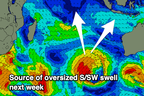
We then look at the more significant swell due into next week and the source will be a slow moving, broadening and healthy low that’s currently projecting up from the Heard Island region. A sustained fetch of SW tending S/SW gales will be projected towards Indonesia, with a final surge once positioned west of Western Australia.
It won’t have the strongest period but the size looks bigger than that of the coming swells for the weekend, also lasting a couple of days.
Following this things go a little more quiet into the middle of the month ahead of more moderate to large surf from about the 17th.
----------------------------------------------
Winds are finally backing down across the Maldives with various pulses of large S’ly groundswell and a moderate-large pulse of S/SE trade-swell that peaked through the day Tuesday and yesterday.
This activity is now settling down across the region with the trade-swell on the decline, though some new, large inconsistent S’ly groundswell should start showing later today, building further through tomorrow, holding Saturday and then easing Sunday,
The source was the same as the first swells mentioned above for Indonesia (south-east of South Africa), with moderate-large sized sets due across the southern atolls into the afternoon Friday, holding Saturday before fading Sunday.
Following this, the storm generating the oversized Indo swell should come in Tuesday afternoon across the Maldives with large sets getting in everywhere, easing slowly Wednesday.
We should see a renewal of S/SE tending SE trade-swell energy through the weekend but more so next week and the week following thanks to strengthening E/SE winds south of the region over the coming days, initially weakening early next week before expanding later in the week.
Moderate to large levels of swell are due but we’ll look at this in more detail Tuesday along with further good pulses of S’ly groundswell.
Eastern Indonesia:
Easing S/SW swell today, further tomorrow morning.
Large, inconsistent SW groundswell building later Friday, peaking Saturday in the 8ft range, easing Sunday but slowed by a reinforcing S/SW pulse to 6-8ft, smaller into Monday.
Oversized S/SW groundswell building Tuesday, peaking later and into Wednesday morning to 8-10ft, easing slowly into the end of the week.
Fresh E/SE trades, lighter and more variable each morning. Lighter trades possible later next week.
Uluwatu 16-day Forecast Graph/WAMs
Western Indonesia/Mentawais/South Sumatra:
Easing S/SW swell today.
Large, inconsistent S/SW groundswell building tomorrow, reaching 8ft later, easing Saturday morning from a similar size.
Reinforcing large S/SW swell Sunday morning, easing Monday.
Oversized S/SW groundswell building Tuesday to 8-10ft, easing slowly Wednesday and into the end of the week.
Variable winds, tending W/NW-NW at times to the north from the weekend into early next week.
Mentawai 16-day Forecast Graph/WAMs
Maldives:
Easing SE trade-swell today, tomorrow and Saturday.
Large pulse of long-period S’ly groundswell building tomorrow afternoon, reaching 6ft+ across the southern atolls Saturday, easing slowly Sunday.
Moderate + sized S/SE trade-swell building Sunday, further into Tuesday/Wednesday, peaking to 4-6ft, easing a touch after.
Large sized S/SE groundswell for later Tuesday/Wednesday to 6ft+ across southern atolls, 4-6ft to the north.
Moderate sized background S’ly groundswell for Thursday to 3-5ft across the southern atolls.
Larger SE trade-swell for next weekend.
Moderate S/SW-SW winds tomorrow, freshening Saturday, tending more SW while easing a touch Sunday and Monday.
SW winds across central to northern locations mid-late next week, S to the south.
Comments
The latest notes are live.
interesting mix of trade and doldrum-y winds in the ments
Yeah they should back off tomorrow.
Epic, a few rights on the Sumatran mainland come to mind :-)
Noice
https://www.youtube.com/live/9O0fArjvG3k?si=we8uGAAYtFPihnvs
Is this the same comp they ran in Krui recently? I arrived just after, and there was still a buzz in the community; it looked like it left somewhat of a positive impact.