Indonesia/Maldives forecast February 6

Indian Ocean Basin analysis by Craig Brokensha (issued Tuesday 6th February)
This week through next (Feb 2 - 9)
Background levels of S/SW swell that are currently ebbing and pulsing across the region should be made the most of as the current outlook for the next two weeks is very slow.
The size will fade from Thursday, bottoming out into the weekend with small, background levels of mid-period SW swell due early-mid next week, easing into next Thursday.
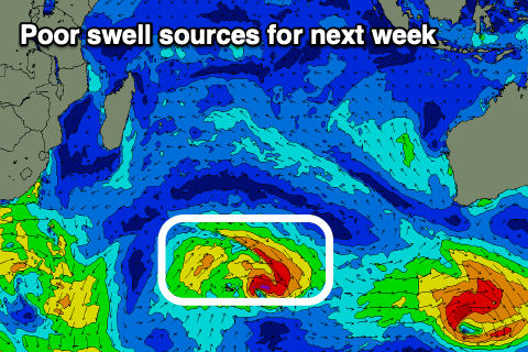
From next weekend, the outlook remains slow with tropical activity expected to dominate the Indian Ocean with no substantial Southern Ocean activity. The mid-summer doldrums are real.
Conditions should remain favourable for the south magnets with morning W/NW-NW winds, freshening from the W/SW into the afternoons, lighter into next week. Across in the Ments variable winds are due over the coming period for the most part, freshening a little Friday afternoon and evening.
Across to the Maldives, easing levels of mid-period S’ly swell are being seen, with a new S/SW swell due later in the week, though local levels of NE windswell look to become more dominant.
This will be thanks to strengthening E/NE monsoon winds today, weakening a little later week before kicking back up again into the weekend. This unfortunately looks to be the dominant swell source for the period.
Eastern Indonesia:
Small, inconsistent mid-period S/SW swell today, tending more S tomorrow (3-4ft from Bali west, smaller to the east). Easing surf into the end of the week and weekend.
Small, inconsistent background SW swell for early-mid next week to 3ft+ on the magnets.
Weak W/NW-NW tending fresh W/SW winds over the coming days, weaker into the afternoons next week.
Uluwatu 16-day Forecast Graph/WAMs
Western Indonesia/Mentawais/South Sumatra:
Easing, small mid-period S/SW swell tomorrow, into the weekend. Small, inconsistent background S/SW swell for early-mid next week to 3ft on the magnets
Variable winds this period.
Mentawai 16-day Forecast Graph/WAMs
Maldives:
Easing mid-period S’ly swell tomorrow, with a small background swell to 2-3ft Thursday/Friday, easing into the weekend.
Weak NE windswell for the coming days, building again into the weekend and next week.
Strong E/NE winds, easing and tending more N/NE-NE into the end of the week, strengthening from the E/NE into the weekend.
Comments
Latest notes are live.
Cheers Craig , was pleasently surprised yesterday when I went out for an onshore grovel. Wind dropped and swell started pulsing with overhead sets (4-5ft ) and 6 waves to a set . Local rippers were out and frothing. The swell has stayed consistent for weeks now , mainly head high but every now and then like yesterday arvo some overhead pulses and I just wait for the windows during the day when wind drops and occasionally even turns offshore. These small storm cells come over penida and it goes offshore here but still blowing sw in Bali. Back to oz tomorrow to pick up 3 boards and more gear then back Saturday . Really appreciate your reports .
Need a break. Running on fumes after surfing back to back to back to back etc etc etc.
Surfing during those thermonuclear storms is never dull. Vision down to 5M maximum as you’re pelted by fat monsoonal marbles of rain. Then the front passes and its oil slick mirror glass.
Hi Craig, any plans to issue a long range forecast for the Indian Ocean basin for autumn?
Only if I can see any major drivers.