Indonesia/Maldives forecast January 16

Indian Ocean Basin analysis by Craig Brokensha (issued Tuesday 16th January)
This week through next (Jan 17 - 26)
An inconsistent S/SW groundswell due later yesterday and today should have provided a slight increase in size across the magnets though not to any major size, with it backing off through tomorrow.
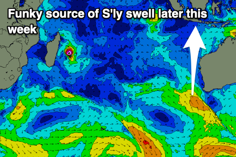
The easing trend will then continue into the end of the week, with the next pulse of swell being a funky one, coming in from the true S’th across eastern Indonesia, S/SE in the Mentawais but smaller. Locations in between look to see this swell the strongest, with it missing the further east of Bali you go.
The source was a fetch of strong to sub-gale-force S/SE winds to the south-west of Western Australia yesterday, feeding into a surface low/trough.
This swell should arrive through Friday afternoon, with it peaking overnight and easing rapidly on Saturday.
Following this a very inconsistent SW groundswell is due to arrive later Saturday, building towards a peak on Sunday afternoon.
It’ll be small to moderate in size and inconsistent, generated by a distant polar low that formed south-east of South Africa on the weekend.
Following this localised windswell out of the western quadrant looks to dominate eastern Indonesia thanks to strong monsoon activity, with not much to work with further to the west (Mentawais).
Therefore try and make the most of the small pulses of coming swell.
Looking at the local winds and slowly freshening W/NW-W winds are due across eastern Indonesia this week, stronger next week while the Mentawais will see a NW surge through this week, easing back next week.
Over in the Maldives, strong monsoon winds seen the last couple of weeks are now starting to ease across the region though will persist in this weaker mode for the period.
This will keep small levels of weak E/NE swell to 2-3ft continuing across the northern and central atolls.
Other swell sources revolve around a tropical cyclone that formed off Madagascar, but this doesn’t look to have any major swell generating winds on its western flank.
Instead, the polar low linked to Indonesia’s inconsistent groundswell should arrive Friday and offer good sized sets on the southern atolls later in the day, easing Saturday.
There’s also some mid-period SW swell likely from a stationary fetch of W’ly winds setting up to the immediate north-east of Madagascar next week, though we’ll look at this in more detail Thursday.
Eastern Indonesia:
Small, easing S/SW groundswell tomorrow.
Small-moderate sized, mid-period S’ly swell for later Friday to 3ft to possibly 4ft, easing Saturday from a similar size. Smaller east of Bali.
Morning W/NW winds, fresher W-W/SW into the afternoons, strengthening next week, bringing an increase in localised windswell.
Inconsistent SW groundswell building later Saturday, peaking Sunday afternoon to an inconsistent 4ft on the magnets.
Uluwatu 16-day Forecast Graph/WAMs
Western Indonesia/Mentawais/South Sumatra:
Fading S’ly groundswell tomorrow, mixed in with a W’ly windswell this afternoon, also easing slowly into the end of the week.
Small mid-period S/SE swell Saturday to 2-3ft on the magnets.
Inconsistent SW groundswell building Saturday, peaking Sunday to 4ft on the magnets.
Strengthening NW winds over the coming days, easing into the weekend and next week.
Mentawai 16-day Forecast Graph/WAMs
Maldives:
Weak E/NE windswell to 2-3ft across northern regions for the coming period.
Inconsistent, moderate sized S’ly groundswell building Friday, reaching 4ft+ on the southern atolls late, easing Saturday from a similar size.
Persistent, moderate to fresh E-E/NE winds across northern and central locations, tending N/NE-NE across southern locations. Winds freshening next week.
Comments
Latest notes are live.
Cheers Craig
Keep an eye on PNG. Swell expected to build from 20th, peaking 22/23 January is expected to be the biggest to hit North Facing PNG since 2008. Some locals concerned about potential damage across the coast from such large powerfull swell. Could have significant effects across Micronesia and Solomons too
Good looking swell for sure, almost indo like swell periods. Just be aware that some model outputs are doubling up on swells for 22/23rd.
Lembongan sure is a weird place when it comes to weather. It started blowing easterly at about 2.00pm today and even though it’s only knee to waist and occasionally chest high plus inconsistent, the Australian kids on school holidays are having a ball . I checked the cams on surfline and it’s blowing sw at ulu’s and sse at keramas . In the dry season when the trades have kicked in and Ulu’s is offshore all day , Lembongan has this weird thing going on where the wind goes around in circles during the day . The surf is currently the smallest it’s been in 5 weeks , fishing looks promising on 21-22 this month if winds hold off in the morning. Still really nice weather over here and even humidity is not too bad , waters cool and refreshing .
Sunset yesterday …….morning walk


Enjoying life SF, good one mate
Should be a decent rise in swell in the morning if south swells get in where you are SF. Great pics by the way.
Nice Supa, yeah interested to see how the south pulse goes. Due tomorrow.