Large clean swells this weekend, with another good swell next week

Hawaii North Shore, Micronesia and PNG forecast by Craig Brokensha (issued on Tuesday 5th March)
Best Days: Every day over the coming period
This week and next (Mar 6 – 14)
Hawaii: A small pulse of mid-period N/NW swell is breaking across the North Shore, offering OK waves for keen surfers and we'll see this ease through this afternoon, smaller into tomorrow morning.
The surf will remain on the small side the rest of the week, but come the weekend a large long-period NW groundswell is due to fill in across the islands.
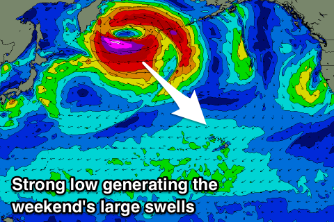 This will be generated by a strong low forming off the Kamchatka Peninsula, with a fetch of severe-gale to storm-force NW winds produced in our far swell window, swinging more W/NW through Wednesday and Thursday.
Two seperate pulses of long-period groundswell are due from this low, the first out of the NW for Saturday, with a secondary kick arriving overnight for Sunday morning.
Size wise the North Shore should see large 10-12ft surf on Saturday, easing from 10ft or so Sunday morning and with gusty but favourable E/NE trades.
A secondary low is due to form in a similar spot but be a touch smaller in scope a little weaker and not as consolidated. Still we should see another long-period and inconsistent NW groundswell for Tuesday week to 8-10ft across the North Shore with moderate E/NE trades, easing slowly through the rest of the week.
Following this there's nothing too significant on the cards, so try and plan around the coming swells.
North Shore Forecast Graph
North Shore WAMs
Micronesia: The first low forming off the Kamchatka Peninsula will produce a burst of gale to severe-gale N/NW winds briefly in our swell window as the low develops, producing a good pulse of long-period N/NW groundswell for the weekend.
We should see north facing reef passes building later in the day Saturday to 3-4ft, easing Sunday from 3-5ft and with favourable E/NE trades.
Beyond this there's no significant swells from the N with building levels of E/NE trade-swell that should start to wrap in from later next week.
Palikir Pass Forecast Graph
Palikir Pass WAMs
Papua New Guinea: The come forecast period is fairly straight forward. We'll see steady levels of NE trade-swell through the coming period with variable winds and weak afternoon sea breezes.
Exposed spots should come in at 3-4ft, if not for the odd bigger one at times, while we may see a bit more energy developing later next week as the trade-flow broadens and strengthens in scope a little. More on this Thursday.