Quickly easing surf, new groundswell for early next week

Hawaii North Shore, Micronesia and PNG forecast by Craig Brokensha (issued on Thursday 18th January)
Best Days: Hawaii - Thursday morning, Sunday through Wednesday, Micronesia - Friday through Sunday morning, later Monday onwards, PNG - Every day at magnets
This week and next (Jan 19 - 26)
Hawaii: A reinforcing N/NW groundswell has filled in this afternoon offering large sets across the North Shore upwards of 8ft with larger sets at north magnets.
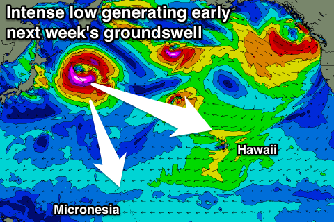
This swell was generated by an intense but late forming low in our swell window, with it moving off quickly to the east.
 As a result we'll see the swell ease quickly overnight, back from the 6ft range tomorrow morning, much smaller Friday.
E'ly trades will strengthen into tomorrow morning as a strong high to our north-east is squeezed, relaxing into Friday and further over the weekend as the pressure gradient relaxes.
We've had an upgrade in the intensity of one of the lows forming off Japan over the coming days and a subsequent upgrade in the W/NW groundswell due early next week.
A tight fetch of storm-force W/NW winds will be generated in our western swell window, generating a fun long-period W/NW groundswell that's due to build strongly through Monday, peak early Tuesday.
At this stage we're looking at inconsistent but great quality sets building to 6ft+ later Monday, easing from 6ft to occasionally 8ft early Tuesday. It's worth noting that ahead of this swell, on Sunday a small kick in size should be seen to 4ft+ from a new NW groundswell.
Longer term the outlook still remains slow with no major swells due into the end of the week and following week at this stage. More on this next update on Tuesday.
North Shore Forecast Graph
North Shore WAMs
Micronesia: Later today we should be seeing a fun pulse of N'ly swell filling in, reaching 3-4ft by dark and holding a similar size through tomorrow and Saturday morning before starting to ease.
Gusty E/NE trades will keep conditions relatively clean in protected spots, poor at more open locations.
The intense low forming off Japan should generate a slight pulse of N/NW groundswell for Monday/Tuesday, building to 3ft on the sets Monday afternoon, easing from a similar size Tuesday.
The low will stall slightly on the edge of our swell window south of the Kamchatka Peninsula, providing a reinforcing N'ly groundswell to the 3ft range Thursday and Friday.
Beyond this we may see some better N/NW groundswell next weekend onwards, but more on this Tuesday.
Palikir Pass Forecast Graph
Palikir Pass WAMs
Papua New Guinea: Fun amounts of NE trade-swell are currently breaking across the region though we'll see it slowly easing from Saturday, smaller into next week but hanging around an infrequent 2-3ft.
The best pulse of N/NW groundswell is likely from Tuesday next week, through the rest of the week but the size looks to be under the trade-swell, coming in at an infrequent 2ft+.
Comments
Hi Craig, Geez the late Jan f/c for Hawaii looking grim.....whats causing the lack of swell? is there a blocking pattern? Do you see it lifting anytime soon.....off to PNG in early Feb....getting worried that La Nina is going to skunk us...