North Shore swells this week, slow afterwatds

Hawaii North Shore, Micronesia and PNG forecast by Craig Brokensha (issued Tuesday 7th March)
Best Days: North Shore every day until Sunday, Micronesia and PNG Wednesday through the weekend, then later next week
This week and next (Mar 8 – 17)
Hawaii: A large increase in W/NW swell through yesterday was still coming in strong today at breaks that like westerly swell, around 6ft at other spots.
This swell should start easing off through tomorrow while tending slight more NW in direction, back from 5-6ft on the sets across magnets, bottoming out Wednesday morning.
The remnants of the low responsible for our current swell has re-intensified to our north-northwest and with this we're seeing a good fetch of gale to severe-gale N/NW winds projecting towards us.
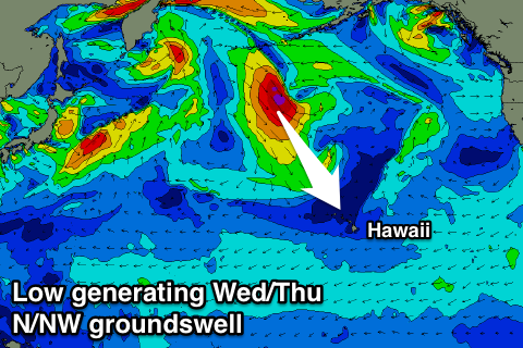 This will generate an oversized N/NW groundswell for Wednesday afternoon and Thursday morning, with magnets due to build to 10-12ft by dark, easing from a similar size Thursday morning.
Conditions will be OK Wednesday afternoon as winds tend NE, with light offshore breezes Thursday.
Friday will be smaller with slowly freshening NE winds.
From the weekend small to tiny surf is due across the North Shore with no significant swell due at all.
A small mid-period pulse is expected Monday/Tuesday but only to 4ft, with an inconsistent small to moderate sized W/NW groundswell for later week.
Longer term there's nothing significant showing on the charts, so make the most of the coming week's swells.
North Shore Forecast Graph
North Shore WAMs
Micronesia: Our large N/NE groundswell seen the last couple of days across the region has dropped back a little into today, but a reinforcing pulse this afternoon should keep 5-6ft sets hitting north facing breaks, easing back through tomorrow from 4-5ft tomorrow morning, smaller Thursday from 3ft.
 From here on small levels E/NE trade-swell are expected to 3-4ft across exposed breaks, easing off slowly towards the end of the week and into the weekend.
With the easing trade-swell strong E/NE trades will also ease off, becoming more variable for a period Tuesday through Thursday next week. Exposed breaks will be lucky to see surf above 2ft though.
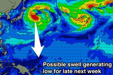
Longer term a small N/NW groundswell is possible Thursday next week, generated by a weak low spawning off Japan. Size wise we're looking at 3-5ft sets, but well have another look at this Thursday.
Palikir Pass Forecast Graph
Palikir Pass WAMs
Papua New Guinea: The strongest pulse of NE groundswell should be filling in across north facing breaks this afternoon, reaching 4-5ft+.
A reinforcing pulse of swell should keep 4-5ft sets hitting the coast through tomorrow, easing off from the 4ft range Thursday and 3ft Friday morning.
Our current E/SE breeze will weaken off from Thursday, more variable for the rest of the period.
Also in the mix will be small levels of NE trade-swell, smaller than the NE groundswell and also easing at a similar rate, with inconsistent 2ft sets max at swell magnets into early next week, tiny late week.
The groundswell impacting Micronesia Thursday should arrive Friday/Saturday, but more on this Thursday.