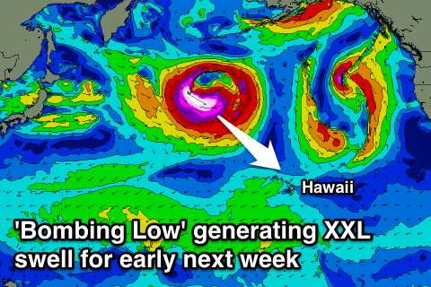
Increased activity from Thursday, XXL swell likely for Monday
Hawaii North Shore forecast by Craig Brokensha (issued Tuesday 29th December)
Best Days: Tuesday morning, Thursday, Saturday afternoon and Sunday for experienced surfers only, Monday for watching from shore
This week and next week (Dec 28 – Jan 8)
A good kick in N/NW groundswell later yesterday and this morning is now on the ease with dropping 6ft+ sets across the North Shore.
We'll continue to see this swell fading through tomorrow from 4-5ft or so with variable winds, bottoming out into Wednesday as less favourable and fresh NE winds kick in (a good lay day).
From Thursday we'll see the first in a series of moderate to large swells, climaxing with an XXL event early next week.
Firstly a relatively weak (compared to what's following it) frontal system will push down towards us over the coming days, aiming a fetch of NW gales close to the islands.
This should produce a moderate to large sized and consistent NW groundswell for Thursday to 8-10ft+ across the North Shore. A temporary drop in size is due into Friday from 8ft or so ahead of secondary front moving in over an already active sea state.
Again this front won't have any major strength but it's close projection towards Hawaii and track over an active sea state should produce another NW groundswell in the 10ft range for Saturday.
A third larger N/NW groundswell pulse is then expected Sunday from a stronger and tight fetch of severe-gale NW winds projecting towards us later in the week more though our northern swell window.
Large 12ft+ surf is due most of Sunday, easing later in the day.
 Coming back to the conditions expected from Thursday and weakening E/NE trades should create good conditions with average and freshening N/NE winds into Friday, swinging from the NE back to the E/NE through Saturday before weakening into Sunday from the E/NE.
Of much greater importance is the development of a 'bombing low' directly east of Japan Friday evening. A bombing low is a weather system which drops over 24hPa in central pressure in less than 24 hours.
Once the low 'bombs' it's expected to track ideally east towards Hawaii while generating a fetch of severe-gale to hurricane-force W/NW winds.
A very large and powerful long-period W/NW veering NW groundswell is due to be created, filling in Monday and reaching the XXL range through the day. The North Shore should see large 20ft+ waves with bigger sets at outer reefs and offshore bommies along with fresh E/NE trades.
Check back here on Thursday for a closer look at the size and conditions for this monster swell.


Comments
Watch this space..
Perfect