Excellent surf ahoy!

Eastern Tasmania Surf Forecast by Ben Matson (issued Wednesday 5th May)
Features of the Forecast (tl;dr)
- Building NE swells Thurs onwards, pulsing strongly through Fri though with tricky winds
- Large NE swell Sat, easing slowly Sun, with excellent conditions
- Mixed outlook for next week
Recap
Not much surf around for the last few days. A small long period S'ly swell was detected at the Maria Island wave buoy overnight on Monday (Tp of 18 seconds) but it only favoured a handful of exposed south swell magnets on Tuesday, and eased through the day and further into this morning.
This week (May 4 - 7)
*Today’s Forecaster Notes will be brief as Craig is away*
No major change in surf expectations for the next few days, with very small levels of energy early Thursday expected to build slowly from the E/NE through the day ahead of a more pronounced increase throughout Friday.
However, the models have strengthened a pre-frontal northerly flow across Tasmania on Friday, and this has increased the potential for dicey winds across the East Coast, particularly across more southern regions.
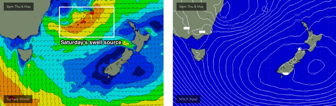
Wave heights should push 3-4ft by late Thursday but late Friday afternoon’s likely be in the 6ft+ range, possibly bigger, sourced from a slow moving easterly trough low currently developing in the Tasman Sea (see below).
I’m still expecting the peak of the swell to occur on Saturday but this doesn’t rule out the change for a broad plateau over 24-48 hours, instead of the usual up/peak/down trends we often experience. Of course, the average wind outlook somewhat lessens expectations in this regard.
This weekend (May 8 - 9)
So, the whole weekend - in particular Saturday - is looking pretty amazing if you’re keen on large east/north-east groundswells.
Open beaches should reach peak somewhere around 6-8ft on Saturday, and winds are expected to freshen from the west as a front clips the state. A gradual easing trend will occur through Sunday though early morning should still be very large, probably in excess of 6ft before easing to 4-6ft through the day.
Conditions will be great early under a light W’ly breeze but another front rearing up from the west will freshen NW then N/NW breezes through the day.
Next week (May 10 onwards)
Next week initially looks very complex with a tricky cut-off low below South Australia currently modeled to do all kinds of crazy things in and around the Tasmanian region, most of which probably won’t eventuate right now. But, with the weekend’s event steadily easing (still 4-5ft Monday, 3-4ft Tuesday), we’ll have to work around the local winds - which are difficult to have confidence in right now.
Either way, the long term trend beyond this points towards a return to a more classic autumnal pattern which suggests reduced activity from our eastern swell window, and more flukey south swells bending around the Cape and glancing the swell magnets along the East Coast later next week.
As such, make the most of this weekend!
See you Friday.
Comments
Gonna be a little late with this forecast tonight, sorry.
Maria Island buoy is looking very good though!