Run of onshore winds and E/NE swell

Eastern Tasmania Surf Forecast by Craig Brokensha (issued Wednesday 17th March)
Best Days: South swell magnets Friday for the desperate, northern corners Tuesday and Wednesday, southern corners Thursday
Features of the Forecast (tl;dr)
- Slow increase in E/NE swell energy over the coming days, with some NE swell in the mix Tue/Wed but with onshore NE tending E/NE and then N/NE winds
- Small S'ly groundswell for Fri
Recap
A building S'ly swell yesterday with clean conditions in the morning but onshore into the afternoon with the peak in size. Today the swell has eased back from 2ft on the magnets with light morning winds.
This week and next (Mar 18 - 26)
Buckle up, in the wake of the S'ly swell yesterday and this morning we've got a run of onshore winds out of the E-E/NE and building swell from the same direction.
A broad and stubborn high will move into the Tasman Sea, with an arm extending west into the Bight, squeezed on its northern flank by troughs in the northern Tasman Sea and also the south-east of the country.
This will setup a broad and sustained fetch of E'ly winds just within our swell window from tomorrow through most of next week.
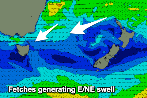 We should see small levels of E/NE swell spreading down from this setup, building slowly through the end of the week but more so on the weekend and into next week.
The swell will be initially windswelly but strengthen, with 1-2ft surf tomorrow, 2ft Friday and then more so 2-3ft Saturday and Sunday.
Winds will be fresh from the NE over the coming days, E-E/NE into the weekend, with the outside chance of pockets of light, more variable winds each morning.
On Tuesday and Wednesday we'll see some additional NE windswell in the mix as the high slowly moves east, swinging winds locally more N/NE as well. Size wise 3+ft sets are due, though not cleaning up until Thursday once a change moves through.
Once winds go south though the swell will ease quickly, dropping from 3ft or so.
It should be noted that there might be a small hint of S'ly groundswell in the water Friday, generated by a 'bombing' low that's currently south-west of the state. This low isn't ideally aimed but stray 2ft sets might be seen on the south magnets.
Longer term there's nothing too significant on the cards, but more on this Friday.