Slight upgrade in northerly swell potential

Eastern Tasmania Surf Forecast by Craig Brokensha (issued Wednesday 10th March)
Best Days: Saturday, Sunday morning
Features of the Forecast (tl;dr)
- Building N/NE windswel Friday with strong N-N/NE winds, peaking Sat AM with strong but easing N/NW tending NW winds ahead of a late S change
- Easing N/NE windswell with W/SW tending NE winds Sun
Recap
Tiny surf yesterday with a small hint of windswell to 1-2ft our of the S'th today.
This week and next (Mar 11 - 19)
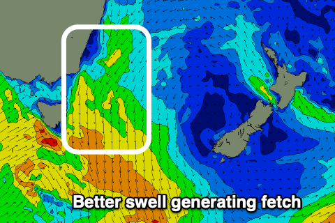
The coming N/NE swell is now looking more robust and noteworthy with the fetch as a whole now forecast to be stronger, more elongated and pushing into the coast.
This fetch will develop as a strong cold front pushing across Victoria late week, squeezes a strong high in the Tasman Sea.
We'll see winds strengthen from the N/NE on Friday, kicking up from 2ft+ at dawn to 3ft through the day, while a peak is due Saturday morning from the strongest winds Friday evening. 3ft to possibly 4ft sets are due out of the N/NE, easing into the afternoon as the cold front moves through.
 Winds on Friday will be strong from the N-N/NE, with Saturday seeing strong N/NW winds, easing and tending more NW ahead of a late afternoon S change. The transition from offshore winds to S will be the time to surf and get the most out of the swell.
Sunday morning looks much smaller, fading from 2ft out of the N/NE, mixed in with a small, weak S'ly windswell.
Longer term, the cold front linked to Saturday evening's change will leave a lingering trough in the Tasman Sea which looks to then deepen off the NSW coast slowly late next week.
We could see this bringing a good run of E/NE swell as it squeezes a strong high sitting east of us, but more on this in Friday's update.