Weak swells ahead of stronger energy

Eastern Tasmania Surf Forecast by Craig Brokensha (issued Wednesday 17th February)
Best Days: Northern corners later Friday and Satuday morning, Sunday, Monday, Tuesday, Wednesday
Features of the Forecast (tl;dr)
- Building N/NE windswell Thu and more so Fri with strengthening N/NE winds, dropping a touch Sat with N/NW tending N/NE winds, smaller again Sun
- NE trade-swell pulse for Sun PM, easing slowly Mon ahead of E/NE groundswell Tue, easing Wed with S'ly winds
Recap
Tiny surf yesterday with clean conditions, onshore today with a small 1-2ft of NE swell.
This week and next (Feb 18 - 26)
We've got two areas to keep an eye on over this coming period, that being locally, just off our coast (the source of N/NE windswell), and then across the northern Tasman Sea, bringing less consistent though stronger levels of NE trade/groundswell.
Firstly, the N/NE windswell will be the most noticeable over the coming days, with a low forming under Western Australian due to dip south-east through the Bight, squeezing a strong high just west of New Zealand.
This will see strengthening N/NE winds through our swell window from this evening through until Saturday, weakening as the low clears. A secondary trough moving through Sunday will finally cut off the infeed of winds through the day.
Size wise, nothing special is expected with building sets from 2ft to occasionally 3ft tomorrow morning across north-east magnets, more to 3ft later in the day, bigger Friday and building to 3-4ft or so. Winds will be poor and fresh to strong from the N/NE tomorrow, stronger N/NE on Friday.
Saturday should see winds relax and tend N/NW in the morning (back to the N/NE through the afternoon) along with easing surf from 3ft or so. A drop in N/NE swell from 2ft to possibly 3ft is then due Sunday as the trough edges in, bringing N/NW tending late S/SE winds.
 Now, as the N/NE swell fades, we look at a fresh pulse of NE trade-swell Sunday afternoon, followed by E/NE groundswell on Tuesday/Wednesday.
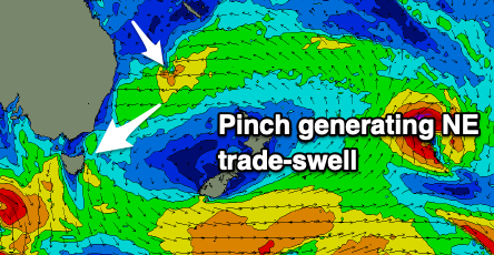
The trade-swell will be generated as a broad fetch of easterly trades and fully developed sea state is pinched by a tropical depression in the Coral Sea Friday. This will see winds strengthen and dip more east-northeast into our swell window, and then a movement of the high to the east will see this fetch tipped even more towards us.
 A good pulse of NE trade-swell should be seen Sunday afternoon, building to 4ft across open beaches. This swell is due to ease back from 3-4ft on Monday, but this will be ahead of a stronger E/NE groundswell Tuesday.
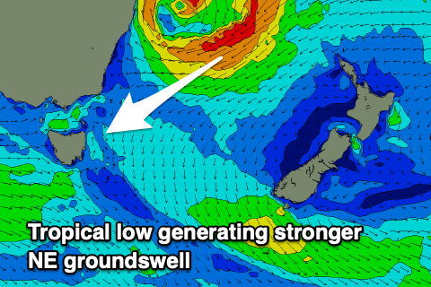
The source will be a tropical low forming off the mainland coast, drifting south, squeezing the high and aiming a brief fetch of E/NE gales towards us.
A larger kick in size to 4-6ft is due to fill in Tuesday from this source and with S'ly winds as well fall under the influence of the western flank of the low. This makes for great surfing options for the savvy. More on all of this Friday though.