Good N/NE swell followed by S swell

Eastern Tasmania Surf Forecast by Craig Brokensha (issued Wednesday 18th December)
Best Days: North-east swell magnets Saturday morning, south swell magnets possibly late Sunday but more so Monday
Recap
No swell yesterday, while today a small and unexpected NE swell to 1-2ft was seen.
This week and next (Dec 19 - 27)
Any small NE swell seen today will be gone tomorrow, but we've got a slight upgrade in a small S'ly swell for Friday.
A weak frontal system tracking under the state tomorrow and onwards to New Zealand will generate a broad but relatively weak fetch of W/SW winds in our southern swell window. A small 1-2ft wave may be seen across south swell magnets Friday morning, fading through the day along with a favourable N/NW tending stronger N/NE breeze. This is a flukey swell source and not really worth chasing.
The strengthening N/NE breeze will be linked to a broader and good looking fetch of N/NE winds developing off our coast and north-east of us as a deep and powerful low forming in the Southern Ocean squeezes a strong high in the Tasman Sea.
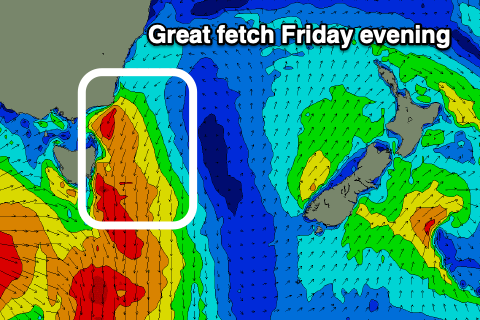 A good spike of N/NE windswell is due from this fetch Saturday, coming in at 3ft to possibly 4ft across north-east swell magnets (check back Friday), though easing into the afternoon with a S/SE change moving through shortly after dawn and then E'ly into the afternoon.
Hit the southern corners through the morning for the biggest and best waves.
This swell will be all but gone on Sunday morning but we'll see the strong low moving east and into our swell window, producing a broad and elongated fetch of strong to gale-force SW winds.
An acute but good S'ly groundswell may be seen Sunday afternoon but Monday is a better chance to surf with south swell magnets expected to come in around 3-4ft or so, much smaller at other locations.
Winds are now looking better than expected on Monday, with a morning N/NW breeze due to swing N/NE through the day, with Tuesday morning hopefully seeing similar sized 3-4ft sets, but easing through the day, We'll likely see a trough bring poor S/SE winds into Tuesday but we'll have to review this on Friday.
Longer term there's nothing too significant on the cards for us, so make the most of the coming N/NE and S'ly swells.