Small mix of S and E swells this week

Eastern Tasmania Surf Forecast by Craig Brokensha (issued Friday 30th August)
Best Days: Tuesday morning, south swell magnets Wednesday morning, open beaches afternoon, Thursday morning
Recap
Large, stormy waves across the coast on Saturday with novelty options for experienced surfers. The swell dropped back to the 3-5ft range yesterday with cleaner conditions, while today a S'ly change has limited options again with the swell persisting at 3-4ft out of the east.
Today’s Forecaster Notes are brought to you by Rip Curl
This week and weekend (Sep 10 - 15)
Today's S'ly change isn'y expected to kick up much in the way of S'ly swell, with tomorrow seeing a mix of easing E/SE swell and S'ly swell from the 2ft range, tiny into the afternoon.
Conditions will be nice and clean though with a W/NW offshore ahead of N/NE sea breezes.
 There isn't much else on the cards for the week, with a small and acute S'ly groundswell expected to show across the south magnets Wednesday.
This will be generated by a tight and intense low moving in under the state tomorrow, generating a fetch of severe-gale but weakening W'ly winds just in our southern swell window.
South facing beaches should see inconsistent 2-3ft sets, tiny elsewhere with NW tending N/NE winds again.
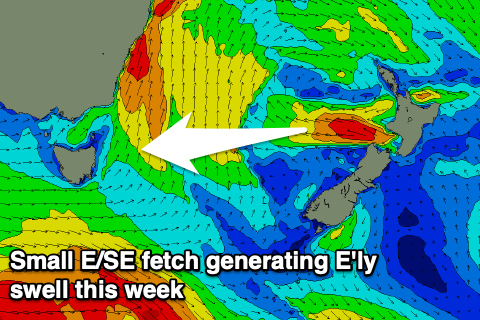
The swell is expected to fade overnight Wednesday, but in the mix Wednesday afternoon and Thursday will be a small, fun E'ly swell.
A fetch of strong to gale-force E/SE winds are expected to be generated off New Zealand's West Coast, producing 2ft+ of E'ly swell for Wednesday afternoon (3ft sets likely) and Thursday morning.
Following this there's nothing too significant on the cards besides a possible S'ly swell from a front pushing past us Saturday, though EC doesn't have too much strength to this. Check back Wednesday for more of an idea about the weekend onwards.