Flukey south swell tomorrow, with a better pulse to come

Eastern Tasmania Surf Forecast by Craig Brokensha (issued Wednesday 15th May)
Best Days: Possibly south swell magnets tomorrow AM, but much more reliable later Sunday/Monday
Recap
Nothing really of note with tiny S'ly groundswell pulses.
Today’s Forecaster Notes are brought to you by Rip Curl
This week and weekend (May 16 - 19)
A slight better pulse of S'ly groundswell is due tomorrow morning, produced by a strong frontal system passing under the state yesterday afternoon and evening.
It might show late today, but tomorrow morning is the best chance for any size, with infrequent 2-3ft sets possible at south magnets, tiny to flat elsewhere.
 The swell will ease through the day and offshore W/SW winds will give into NE sea breezes.
There isn't due to be any real swell left into Friday or Saturday but we've got an upgrade in the swell potential for Sunday and Monday.
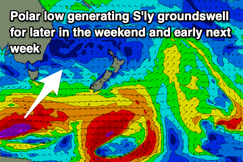
A very intense polar low forming south-west of the state on Friday is forecast to generate a fetch of severe-gale to storm-force W/SW winds in our southern swell window, projecting east-northeast towards New Zealand.
A good S'ly groundswell is due off this low, arriving later Sunday and kicking to 3-4ft at south magnets and easing from 4ft Monday morning. Winds are looking favourable for these spots and from the NE Sunday afternoon, N/NW on Monday.
Following this there isn't anything significant on the cards so try and work your away around this better more reliable swell source.