Great few days with clean swells from all directions

Eastern Tasmania Surf Forecast by Craig Brokensha (issued Monday 6th May)
Best Days: Tuesday, Wednesday, northern corners Wednesday
Recap
Tiny, clean waves leftover from the NE on Saturday morning, while a weak S'ly windswell increase was seen Sunday with average conditions.
Today larger levels of SE swell have begun building on the coast, with the life-cycle of this swell event being brought forward owing to the Tasman Low forming a little closer to us than forecast on Friday. More on this below.
Today’s Forecaster Notes are brought to you by Rip Curl
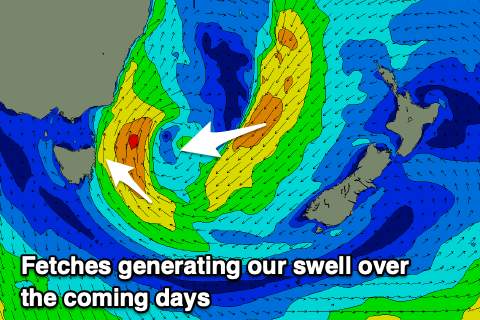
This week and weekend (May 7 - 12)
Over the weekend a broad Tasman Low formed to our east, with a fetch of strong to gale-force SE winds projected towards our coast yesterday and this morning.
This is generating a large building SE swell which is now due to peak later today, easing off rapidly through tomorrow.
 Open beaches should ease from 4-6ft with great offshore W/SW winds, ahead of afternoon NE sea breezes.
The swell will continue to ease Wednesday, mixed with a new inconsistent S/SE groundswell from a polar fetch of SE gales on the weekend, coming in at 2-3ft.
Of greater importance is a better E/NE swell that's due to fill in Wednesday, generated by a great infeed of E/NE winds wrapping around the eastern flank of the low.
The infeed will drop south tomorrow and out of our swell window, though we'll see Wednesday coming in at 3-4ft out of the E/NE, easing from a more E/SE direction on Thursday from 3ft+.
Winds on Wednesday will improve through the day with a dawn N/NW breeze expected to shift W'ly mid-morning and persist out of the W/SW through the afternoon creating excellent conditions.
Thursday should then be best in northern corners with a gusty N/NW breeze.
Now, moving into Friday we've got a very dynamic and intense low forecast directly off our East Coast, with a fetch of S/SW gales possibly being generated in our southern swell window.
The European model ECMWF isn't as strong or as keen as it's American counterpart GFS, so at this stage I'm going to be cautious, with just a fleeting pulse of S'ly swell likely later Friday to maybe 3-4ft at south magnets and with S/SW winds.
By Saturday the low will be far gone and winds offshore, but no swell left in the tank. We'll have to review this Wednesday though so check back then for an update.
Beyond this the westerly storm track looks to fire up favouring the South Arm while we remain tiny to flat.