Good run of southerly swell from Friday

Eastern Tasmania Forecast by Craig Brokensha (issued Wednesday 1st July)
Best Days: Friday, Saturday, Sunday, Monday morning
Recap
Tiny yesterday and a small possible kick in S'ly swell this morning failed to really show any size across the coast.
This week and next week (Jul 2 – Jul 10)
Tomorrow will start tiny but a strong frontal system pushing across and up past the coast through the day should bring with it a late increase in short-range S'ly swell to 3ft+ or so across south swell magnets but with average SW winds.
 Friday is looking much better as a mix of S'ly swells from a trailing fetch of S/SW gales extending to the polar shelf fill in.
We should see south facing beaches pulsing between 3-4ft with a short-range S'ly swell through the morning, and groundswell for the afternoon.
Conditions look excellent as well with a W/NW-NW breeze.
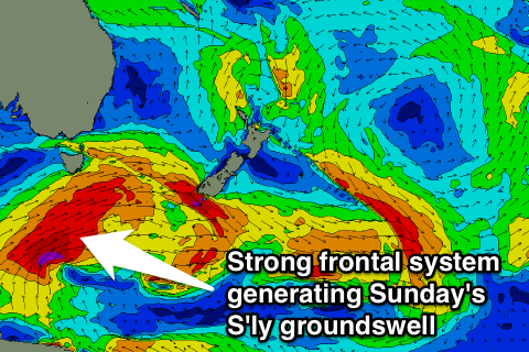
Into Saturday the swell's due to ease back from 2-3ft under W/NW tending W/SW winds as another strong polar front pushes up and past us.
This should produce a strong S'ly groundswell pulse for Sunday, with a fetch of severe-gale W/SW tending SW winds being projected through our southern swell window Friday and Saturday.
This swell should build through the day and reach a strong 4-5ft across south facing beaches under W/NW winds, creating excellent conditions.
Into next week the swell should ease from the S/SE but still be solid and around 3-4ft, dropping back through the day.
Winds look good early before shifting onshore with a deepening trough just off our coast. Now the models are divergent on the strength and position of this trough but we're likely to see building levels of stormy E'ly swell early next week along with strong onshore winds, but check back here Friday for a clearer idea on this.