Fun swells all week at south swell magnets

Eastern Tasmania Forecast by Craig Brokensha (issued Monday 25th May)
Best Days: Every day this week at south swell magnets
Recap
Fun sized S'ly groundswell Saturday with favourable winds, easing back into Sunday from a smaller 1-2ft.
Today a new S'ly groundswell pulse has pushed the surf back up to 2-3ft with 4ft sets at south swell magnets under favourable winds.
 This week (May 25 - 29)
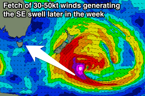
This week we've got some good S/SE and then SE groundswell pulses on the cards, all related to a vigorous polar low that's currently sitting south-southeast of New Zealand.
Initially tomorrow a new S/SE groundswell pulse is due, generated over the weekend by a fetch of severe-gale to storm-force S'ly winds pushing north into New Zealand's South Island.
This is expected to come in at a good 3ft+ across south swell magnets all day under morning W/NW winds and weak afternoon onshores.
A drop in size is then due into Wednesday from 2-3ft under persistent NW-N/NW winds.
Two good but very inconsistent pulses of SE groundswell due across the coast Thursday and Friday, generated by a burst of severe-gale to storm-force SE winds wrapping around the southern and south-eastern flank of the low today and tomorrow.
This should generate two pulses of SE groundswell, the first for Thursday coming in at an inconsistent 3ft+ across swell magnets followed by a slightly stronger pulse Friday morning to 3ft to possibly 4ft.
A drop in size is then due through the day and further from 2ft+ Saturday morning.
Winds look great and offshore from the NW tending W/NW Thursday and then W/NW tending W/SW Friday.
Longer term there's nothing major on the cards until Tuesday next week when we may see a strong cold outbreak moves across the state, possibly bringing some good S'ly swell, but more on this Wednesday.