Small, average period ahead

Eastern Tasmania Forecast by Craig Brokensha (issued Wednesday 25th February)
Best Days: Friday morning for small waves, possibly Saturday morning for a small distant E'ly groundswell (very low confidence), Tuesday morning
Recap
Good but inconsistent levels of NE swell yesterday with favourable winds for southern corners yesterday, with smaller clean waves in the 2ft range this morning.
 This week and next week (Feb 26 onwards)
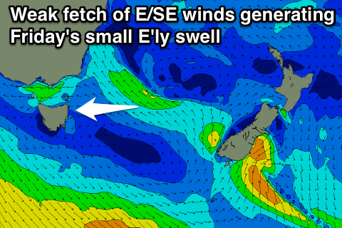
There's nothing to really get excited about over the coming forecast period unfortunately with the NE swell expected to dry up into tomorrow (easing from 1-2ft), while a small E'ly swell may be seen through Friday from a weakening fetch of E/SE winds currently situated between us and New Zealand.
Size wise this isn't expected to get above 1-2ft at open beaches but conditions should be clean Friday morning with a generally variable tending light offshore breeze.
The models are showing a pulse of E/NE groundswell for Saturday morning, but this was generated in the shadow of New Zealand's North Island, in the Western South Pacific and isn't due to provide any size at all across our coast.
A cold front pushing across us Sunday will project a fetch of strong SW winds through our southern swell window to our south-east but there's no major size due off this.
Maybe a 1-2ft wave across south facing locations Sunday afternoon with S/SW winds, before fading Monday from a similar size.
Some small NE windswell to 2ft or so is likely Tuesday morning, while of greater importance is the development of a possible stronger polar frontal progression up past us mid-late next week.
This will be related to a strong node (peak) of the Long Wave Trough moving across us and into the Southern Tasman Sea Wednesday/Thursday next week, generating some refracted S'ly groundswell possibly later in the week. More on this Friday though, as there may not be any size to it if too west in nature.