Fun tomorrow morning, good Monday as winds swing offshore

 Eastern Tasmania Forecast by Craig Brokensha (issued Friday 24th October)
Best Days: Saturday morning, Monday morning
Recap
Yesterday and today have been poor with junky swells along with fresh onshore winds. The weekend is looking better, so read on.
This weekend (Oct 25 - 26)
The surface trough responsible for our recent run of poor swell and winds is now sitting to our north-east and we'll see this squeeze against a strong high in the Southern Tasman before being pushed off to the east early tomorrow morning.
A strong and broad fetch of NE winds will be aimed towards us, generating a good NE swell to 2-3ft across north-east facing beaches before backing off steadily during the day.
Conditions should be great with an offshore W/SW breeze ahead of a fresh S/SE change, limiting the best waves to southern corners which will be picking up the most size.
Come Sunday there's not expected to be any major swell left across the coast, with the S/SE change not generating any meaningful swell. Conditions should be clean with a variable breeze, but the surf tiny and around 1ft.
Next Monday onwards (Oct 27 onwards)
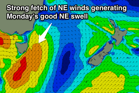
Our larger NE swell for Monday is still on track with a deepening mid-latitude low pushing in from the west expected to squeeze another strong high in the Southern Tasman Sea, aiming a stronger fetch of NE gales through our swell window Sunday evening.
This should produce at least solid 3-4ft waves across north-east facing beaches early as winds swing from an early N/NW'ly around to a gusty W'ly through the day, creating pumping peaky beachies across the coast.
From here on the swell will drop rapidly with nothing major on the cards besides a small refracted S'ly groundswell for Wednesday, but we'll review this again on Monday. Have a great weekend!