Building swell and onshores Thursday/Friday, easing and clean Saturday

Eastern Tasmania Forecast by Craig Brokensha (issued Monday 20th October)
Best Days: Late Wednesday keen surfers, early Thursday north-east swell magnets, Saturday morning
Recap
Tiny levels of NE swell were lingering in the 1-1.5ft range across the coast on Saturday while Sunday was tiny and unsurfable.
A tiny southerly swell kicked up today but with onshore S'ly winds not worth the effort.
This week and Saturday (Oct 21 - 25)
Today's weak kick in S'ly windswell should fade through tomorrow, and a refracted S'ly groundswell isn't expected to offer any major size above a very infrequent 1-2ft at south swell magnets.
Conditions should be clean though with a NW tending fresh N/NE breeze.
This N/NE wind will strengthen into the evening and further Wednesday kicking up a junky N/NE windswell across north-east facing beaches, reaching 3ft through the day.
Winds should kick around to the N/NW late in the day Wednesday but probably not early enough to provide any real decent surf before dark.
 Come Thursday the swell will be fading quickly in the wake of a gusty S/SW tending S/SE change. There should still be the odd 2ft set at north-east facing beaches early.
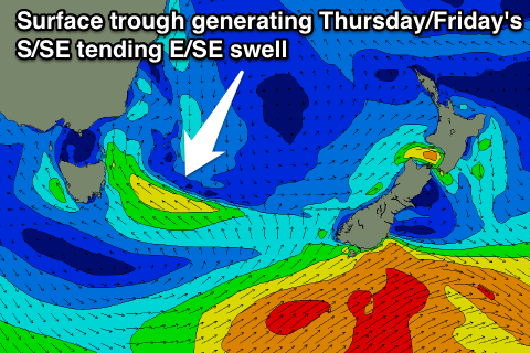
Of greater importance is come better S/SE swell generated by the change and trough moving across us during the day, with a fetch of strong S/SE tending SE winds due to be aimed into us.
This is expected to kick up a junky 3-4ft+ of S/SE windswell through Thursday with onshore winds, but come Friday we should see the swell swing more E/SE and sort itself out more, eminating from the southern flank of the trough sitting to our east.
This should keep open beaches topped up with 3ft+ surf with weakening onshore E/SE tending NE winds.
Saturday will be the day to surf though as winds swing offshore from the NW and then W/SW and the E/SE swell eases from 2-3ft.
This Sunday onwards (Oct 26 onwards)
Another surface trough moving in from the west and across us on Sunday may kick up a new S/SE windswell Sunday but not as large as Thursday's pulse. We'll look at this and the swell through Friday and Saturday in more detail on Wednesday.