Windows of fun waves over the coming period

Eastern Tasmania Forecast by Craig Brokensha (issued Wednesday 18th June)
Best Days: Thursday at south swell magnets, Saturday at open beaches, Sunday and Monday in northern corners, Tuesday morning
Recap
Yesterday became tiny, but today a slight lift in SE swell was seen across the coast to 2ft on the sets.
This week (Jun 18 - 20)
A better pulse of S'ly groundswell is due tomorrow across the coast, generated by a vigorous polar front firing up from under us, with it currently pushing towards New Zealand.
This swell should fill in and peak through the middle of the day with sets to 2ft+ expected across south swell magnets. Open beaches will be tiny, but with NW winds it will be worth scouting out those locations exposed to the south swell.
A drop in size is due through Friday from 1-2ft or so as winds persist from the W/NW.
This weekend onwards (Jun 21 onwards)
The weekend's S/SE swell has been moved around a little, with the polar low generating the swell splitting into two distinct fetches.
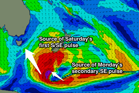 An initial fetch of severe-gale S/SE winds pushing towards New Zealand should generating an initial pulse of S/SE groundswell for Saturday, building to 2-3ft at open beaches.
Behind this though an additional fetch of severe-gale E/SE winds should generate an additional pulse of SE swell for later Sunday and more so Monday, providing slightly better 2-3ft+ waves at open beaches all day. In between the pulses on Sunday though we're likely to see a touch less size.
Winds through Saturday's first pulse will be great and offshore from the W/NW ahead of N/NE breezes into the afternoon. Sunday will then be best in northern corners with an increasing N/NW tending N'ly breeze.
Monday will see even stronger N'ly tending NW winds, and with this some N/NE windswell is expected to be mixed in with the inconsistent SE groundswell but under the forecast 4ft (probably more 3-4ft).
From Tuesday onwards there's not expected to be much on the cards with a fading SE swell from 2ft or so at open beaches and then a possible small increase in S'ly swell later Wednesday/Thursday. Check back here on Friday for an update on this though.