S'th swell to end the week, with NE swell for Sunday/Monday

Eastern Tasmania Forecast by Craig Brokensha (issued Wednesday 28th May)
Best Days: Later Thursday, Friday morning, Monday as winds tend variable, Tuesday
Recap
Monday's solid increase in S'ly groundswell backed off from a fun 2-3ft across the coast yesterday morning under offshore winds.
Today a tiny NE windswell has come in above expectations with 3ft waves across the coast with all day offshores. The swell should of eased off into this afternoon but we've got a new pulse of S'ly swell due tomorrow.
This week (May 28 - 30)
Tomorrow's increase in S'ly swell has been upgraded with the polar front that's currently to our south, linked to the swell, coming in a touch broader and stronger than forecast on Monday morning.
This should generate a fun pulse of S'ly swell during the day tomorrow, reaching 2-3ft+ at south facing beaches but with poor S'ly winds during the morning. These winds should ease rapidly and tend more variable into the afternoon, so this will be the time to surf across the coast.
Friday morning should be cleaner with an offshore W/NW breeze but the swell will ease quickly from 2-3ft at south facing locations.
This weekend onwards (May 31st onwards)
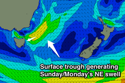 Tiny levels of S'ly swell will fade through Saturday but Sunday and Monday are looking better as a surface trough to our north deepens. This will aim a fetch of strong NE winds into us, kicking up a stormy 3-5ft of NE windswell later Sunday ahead of a peak Monday morning out of the E/NE to 4-5ft or so. The trough will drift south through Monday resulting in Sunday's onshore winds easing during the day and tending variable, creating fun lumpy waves across the coast.
Tuesday will be the cleanest day to surf with a dropping E/NE swell from 2-3ft or so under SW tending SE winds.
The rest of the week remains void of any major swells as Monday/Tuesday's swell continues to ease, therefore make the most of the small windows of cleaner conditions over the coming period and check back here on Friday for an update on the NE tending E/NE swell.
Comments
Can anyone tell me why the forecasts for South Arm and East Coast Tas have been so wrong lately? I've had a few people mention this to me and I'm just trying to understand what is happening because I've spent some coin on fuel lately and hardly been in the water. It seems to be both swell and wind predictions are so far out its not funny. When I get the chance to go the forecast say it will be good and it end up crap and when its supposed to be average it turns out to be pumping? Not having a dig just trying to suss things out!
South Arm forecasts, model and written (besides today) have been pretty good from what I've seen. Even those funky south swells and S/SE groundswell 3 weeks ago it got nearly spot on.
Looks like that increase in S/SW swell yesterday has held better than expected into today to 2-3ft in the South Arm.
St Helens is a bit trickier as some of the S'ly swells are getting in while others are going straight past.
This morning's S/SE pulse isn't too far off model forecasts which was 3ft at south facing beaches, but if you headed to a location sheltered from the swell it would of been tiny.
The East Coast Tassie model forecasts are the only ones that I've noticed have been a little bit all over the shop. If you had examples that would be great.
Thanks heaps for the response. I'm probably being a bit picky but to give an example, based on Fridays surf forecast for South Arm, if I were making plans to surf on the weekend I would have headed to "Exposed locations" on Saturday i.e somewhere on the peninsular because the forecast indicated that waves on SA would be smaller Saturday with a small increase through Sunday, however I caught a few waves on Saturday on SA which were at least 3ft. These sets were fairly regular and had some punch, so this would tell me that RB on the peninsular would be fairly solid and closing out... I also surfed the same beach on SA on Sunday at roughly the same time as I thought the swell was going to increase during the day with similar tide ,but contrary to the surf report it was much smaller and hardly breaking on the same bank, subsequently this would have been the day to head to exposed locations. I know a few people who also got caught out by this thinking that Saturday would be the day to skip the SA shuffle and explore elsewhere. I understand that SA can be pretty fickle and its a real balancing act trying to predict the waves on the arm as the setup really relies on all the elements to align in order to find a quality wave. Again, not having a crack just trying to get a better understanding of how Swellnet forecasting works as I've always used another website called W... Weather as well so I'm trying to get used to things here . Thanks heaps for your help.
That's a tough one Freezin, Friday's easing swell held in better than expected Saturday when we should of seen a bottom out in heights before that new swell kicked in for Sunday. So Saturday came in over forecast, but Sunday was right on.
The South Arm is a really tricky place to forecast and our model does pretty well for a fully automated product. But I didn't expect much size personally on Saturday either, it's just sometimes those sneaky swells out of the south slip through.
Keeping an eye on the WAMs and synoptic charts will give you a good idea on where which swell is coming from.