Bali: Active period starting from tomorrow

Java, Bali, Lombok, Sumbawa forecast by Craig Brokensha (issued Thu 3rd Jul)
Best Days: Every day over the coming period
This week and weekend (Jul 4 - 6)
After a fun pulse of inconsistent SW groundswell yesterday, wave heights have bottomed out into today with smaller clean surf across most breaks.
Not to worry though, as a large pulse of SW groundswell is due to fill in tomorrow and peak through the afternoon.
There's been no change to this swell since last week, with exposed locations around Bali expected to offer inconsistent 6-8ft+ sets but fresh to strong E/SE trades will favour more protected locations, which will be smaller.
The swell should drop steadily through the weekend (from 6ft to occasionally 8ft early Saturday) as strong E/SE trades on Saturday ease back a touch into Sunday.
Next Monday onwards (Jul 7 onwards)
There's plenty of swell on the cards for next week as a strong node of the Long Wave Trough moving through the Southern Indian Ocean projects a series of vigorous polar fronts up towards us.
An initial vigorous polar front firing up south-east of Madagascar and above Heard Island has already set in motion an initial SW groundswell for Monday.
This swell looks to be slightly bigger than tomorrow's swell and more in the 8ft+ range across exposed breaks.
A secondary smaller reinforcing SW groundswell is then due to arrive Wednesday afternoon (generated by a secondary strong but small polar front just behind the initial system), halting the easing trend and keeping exposed spots topped up with 6ft+ sets.
As the LWT moves over WA Sunday the frontal activity will be directed more through our southern swell window, with one final vigorous polar front due to push up from the Heard Island region, up towards and then into WA over the weekend and Monday.
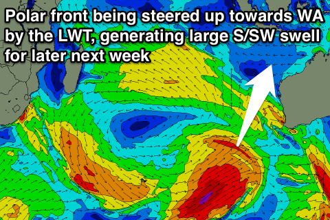 This should generate a larger S/SW groundswell pulse for late in the week arriving strongly late Thursday and peaking overnight before easing Friday.
Size wise this should come in at a good 8ft+ across exposed breaks again, but locations more sheltered and south-west facing will see less size, while spots more angled to the south-east should see bigger sets pushing through compared to the previous swells.
Winds through next week will remain fresh to strong (Tuesday and Wed) from the E/SE but then ease into the end of the week and likely become variable each morning from Friday morning onwards. We'll review this on Tuesday though.
16 day Bali Forecast Graph
16 day East Java Forecast Graph
16 day Sumbawa Forecast Graph
Comments
Windy as Tuban reefs today good size
Daily reports if you can Ricko007