That sets up for a solid spike in NE windswell through Mon as high pressure moves NE and a trough approaches.
Primary tabs
/reports/forecaster-notes/eastern-tasmania/2024/12/13/sizey-ne-windswell-building-mon-tues-s-spike
freeride76
Friday, 13 December 2024

/reports/forecaster-notes/eastern-tasmania/2024/12/11/s-groundswell-short-term-sizey-ne-windswell-mon
freeride76
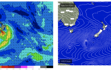
Wednesday, 11 December 2024
A deep low (962hPa) is currently well to the SW of Tasmania and tracking into the lower Tasman, although being shunted to the SE as it does so. We’ll see some S’ly groundswell from this source.

/reports/forecaster-notes/eastern-tasmania/2024/12/09/small-s-pulse-later-week-ne-windswell-early
freeride76
Monday, 9 December 2024
There is a deep low expected to scoot through the lower Tasman, weakening as it does so which may offer some flukey S swell at S swell magnets Thurs/Fri.

/reports/forecaster-notes/eastern-tasmania/2024/12/06/surf-becoming-very-tiny-next-week-while
freeride76
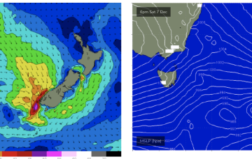
Friday, 6 December 2024
There’s really nothing of interest at all next week with surf remaining tiny right into next weekend.
/reports/forecaster-notes/eastern-tasmania/2024/12/04/small-the-ne-minor-s-swell-the-weekend
freeride76
Wednesday, 4 December 2024
Once the new high sets up shop in the Tasman we’ll see the N-NE flow which has been a constant for a month reset until a front brings a W’ly change on the weekend. No major swells ahead as the pattern of weak, mobile high pressure continues but there’ll be some windows of opportunity with small NE windswell and minor flushes of S swell.
/reports/forecaster-notes/eastern-tasmania/2024/12/02/not-much-all-week
freeride76
Monday, 2 December 2024
No major swells this week, so we’ll be relying on small spikes of NE windswell.

/reports/forecaster-notes/eastern-tasmania/2024/11/29/sizey-ne-swells-over-the-weekend-cut-low
freeride76
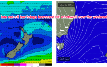
Friday, 29 November 2024
We’ll see the wind flow strengthen on Sat as a large high slips in under Tasmania and multiple troughs and a cut-off low forming over the interior tighten the pressure gradient proximate to Eastern Tasmania.
/reports/forecaster-notes/eastern-tasmania/2024/11/27/sizey-e-tending-ene-swells-over-the-weekend-low
freeride76
Wednesday, 27 November 2024
We’ll see an increasing SE-E flow aimed at Tasmania as winds feed into the cut-off low, generating E’ly swells for NETas into the weekend.
/reports/forecaster-notes/eastern-tasmania/2024/11/25/few-swells-sources-ahead-cut-low-approaches-the
freeride76
Monday, 25 November 2024
E’ly winds feeding into the cut-off low are aimed directly at NETas and will produce sizier swells into Fri.

/reports/forecaster-notes/eastern-tasmania/2024/11/22/small-spell-surf-ahead-promise-mid-next-week
freeride76
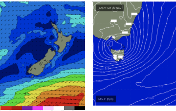
Friday, 22 November 2024
Expect some revisions on Mon but at this stage we should see a developing E-E/NE flow into the trough, aimed up at NETas, possibly as early as Wed.
