That leads to a couple of days of small, weak surf before the low shifts East of Tasmania on Thursday.
Primary tabs
/reports/forecaster-notes/eastern-tasmania/2021/11/08/s-swell-pulses-ahead-some-wintry-wly-winds
freeride76
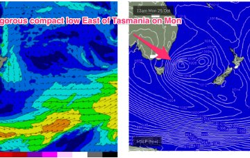
Monday, 8 November 2021
/reports/forecaster-notes/eastern-tasmania/2021/11/05/ne-swell-sat-easing-quickly-through-sun
freeride76
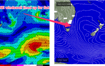
Friday, 5 November 2021
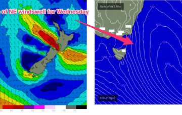
With reinforcing high pressure now in the Tasman Sea, we’re on track for another round of NE windswell through Sat, as the pressure gradient gets tightened by an approaching trough complex and winds freshen in the East Tasmanian swell window.
/reports/forecaster-notes/eastern-tasmania/2021/11/03/more-ne-swell-incoming-the-weekend-and-towards
freeride76
Wednesday, 3 November 2021
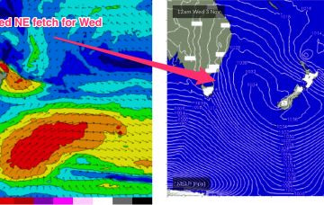
This sees the next round of NE windswell building through Sat as the N’ly fetch freshens adjacent to the Island and extends up the Far South Coast during the day.
/reports/forecaster-notes/eastern-tasmania/2021/11/01/chunky-pulses-ne-windswell-coming-week-and
freeride76
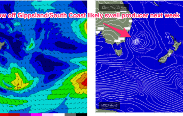
Monday, 1 November 2021
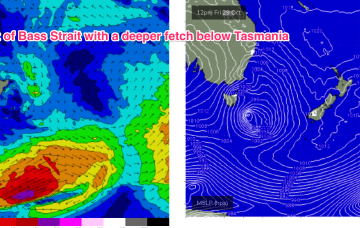
A much stronger intensification of the fetch occurs Wed, as strong to low end gale NE winds develop off Bass Strait, extending up off the Gippsland Coast.
/reports/forecaster-notes/eastern-tasmania/2021/10/29/storm-force-low-moves-away-rapidly-during-sat
freeride76
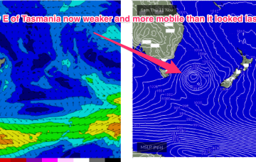
Friday, 29 October 2021
No change to the headline feature: another robust low forming in a trough line East of Tasmania. It does seem to be running early, with gales to storm force winds now occurring out of Bass Strait through the early afternoon and severe gales expected to form adjacent to the East Coast overnight.
/reports/forecaster-notes/eastern-tasmania/2021/10/27/tiny-until-the-weekend-when-another-solid-s
freeride76
Wednesday, 27 October 2021
The weekend looks more reliable as the low moves away during Sat, with gales to severe gales on the western flank of the low generating another strong pulse of S swell for Sat. Expect surf in the 3-5ft range during Sat, with fresh W’ly quarter winds during the day.
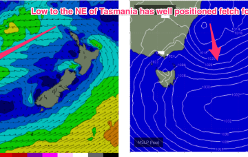
/reports/forecaster-notes/eastern-tasmania/2021/10/25/large-s-swell-now-easing-winds-abating-another
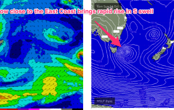
freeride76
Monday, 25 October 2021
The current synoptic pattern is a low pressure system E of Tasmania directing a fetch of SSW to S strong winds to low end gales adjacent to the NSW South Coast and extending south-east of Tasmania. This low then eases as it moves out into the Tasman sea later today.
/reports/forecaster-notes/eastern-tasmania/2021/10/22/unruly-mix-swells-robust-tasman-low-forms-east
freeride76
Friday, 22 October 2021
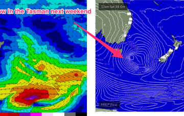
A dynamic weekend is ahead as a robust Tasman low forms near the Island overnight Sat.
/reports/forecaster-notes/eastern-tasmania/2021/10/20/steady-drumbeat-e-swell-week-overlapped-large-s
freeride76
Wednesday, 20 October 2021
Current ASCAT (satellite windspeed) passes show a broad fetch of E to ESE’ly winds feeding into the small low east of Tasmania, with another weak low centre off the NSW Mid North Coast also providing a weak E’ly fetch.
/reports/forecaster-notes/eastern-tasmania/2021/10/18/lots-surf-the-east-week-onshore-winds-abating
freeride76
Monday, 18 October 2021
A trough in the Tasman off the NSW coast deepens into a small, surface low through Tuesday. Compared to model runs on Friday, this slow moving low is now positioned further south, in a more favourable position for swell generation for the East Coast of Tas.