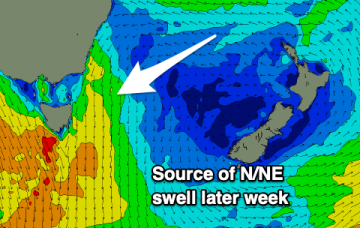
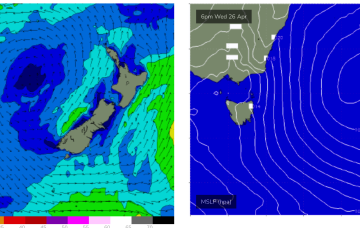
A broad trough of low pressure is expected to bud a surface low near New Caledonia over the short term, generating more quality E-E/NE swell as the low drifts through the South Pacific slot and into the Tasman.
Primary tabs
/reports/forecaster-notes/eastern-tasmania/2023/04/26/couple-fun-days-ne-swell-better-quality-ene
freeride76
Wednesday, 26 April 2023
/reports/forecaster-notes/eastern-tasmania/2023/04/24/eyes-the-ne-windswell-then-groundswell
freeride76
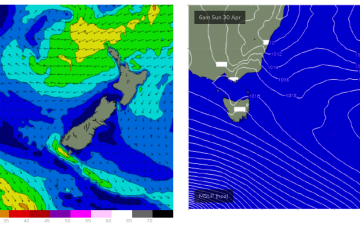
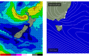
Monday, 24 April 2023
The major swell generator will a broad fetch of SE-E/SE winds in the Coral Sea/Northern Tasman which will be enhanced later in the week as a broad tropical low tracks southwards from New Caledonia and into the wide open Eastern swell window, bringing quality E/NE swell to NE Tas later in the weekend and early next week.
/reports/forecaster-notes/eastern-tasmania/2023/04/21/slow-small-weekend
Craig
Friday, 21 April 2023
Small, inconsistent leftovers for the weekend with a N/NE windswell later week.
/reports/forecaster-notes/eastern-tasmania/2023/04/19/easing-size-the-weekend-ne-windswell-ahead-next
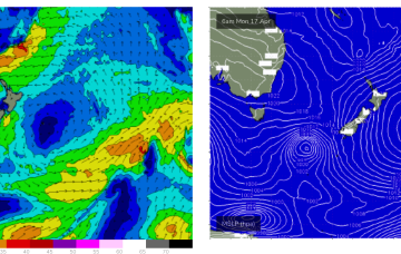
freeride76
Wednesday, 19 April 2023
We still have the trough block pattern in place with the South Pacific low centre contracting away to the NE while a secondary low centre retrogrades back into he Tasman Sea. An anchoring high, is being shunted away with a trough and front expected tomorrow before a new dominant high moves in from the Bight.
/reports/forecaster-notes/eastern-tasmania/2023/04/17/nice-pulses-ene-swell-continue-week-offshore
freeride76
Monday, 17 April 2023
The trough-block pattern set-up nicely over the weekend and we’re looking at a sustained run of swell from the Eastern quadrant. A long, angled trough with embedded low pressure centres on the Eastern flank is concentrating broad E-E/NE infeed fetches in the Eastern swell window.
/reports/forecaster-notes/eastern-tasmania/2023/04/14/great-outlook-next-week-days-solid-ene-swell
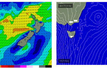
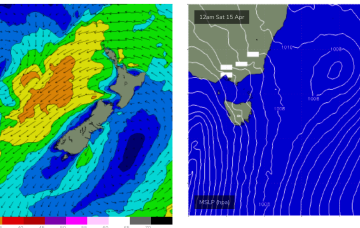
freeride76
Friday, 14 April 2023
Initially the low enhances a broad E-E/NE wind infeed over the weekend, contracting NE into a low pressure centre near the North Island early next week. This fetch is well aimed for Eastern Tasmania and will see a few days of solid E/NE swell from Mon-Thurs.
/reports/forecaster-notes/eastern-tasmania/2023/04/12/swells-the-se-holding-the-weekend-great-ene
freeride76
Wednesday, 12 April 2023
A dynamic trough blocking pattern is then expected to unfold in the medium term. Details below.
/reports/forecaster-notes/eastern-tasmania/2023/04/10/overactive-period-surf
Craig
Monday, 10 April 2023
We've got a lot to deal with this period with plenty of energy out of the south-east followed by east next week.
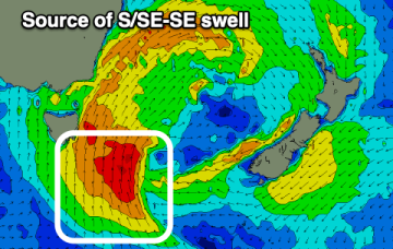
/reports/forecaster-notes/eastern-tasmania/2023/04/07/major-s-swell-episode-inbound-low-deepens-east
freeride76
Friday, 7 April 2023
No great change to the very dynamic Easter weekend f/cast. A mid-latitude low slips East of Tasmania overnight and deepens rapidly as it merges with an incoming frontal system. The front brings a strong W tending SW’ly flow through Sat which will herald the start of a major S swell episode.
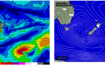
/reports/forecaster-notes/eastern-tasmania/2023/04/05/dynamic-outlook-ahead-powerful-low-generating
freeride76
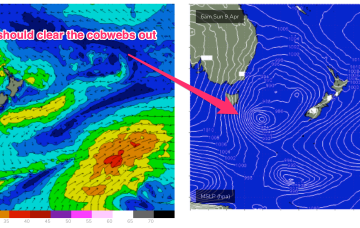
Wednesday, 5 April 2023
Easter Sunday should see a steady upwards trend in S swell, as a strong S swell cycle gathers steam, enough to blow out the cobwebs from our quiet start to Autumn.