Overactive period of surf

Eastern Tasmania Surf Forecast by Craig Brokensha (issued Monday 10th April)
Best Days: Protected spots over the coming days, northern corners Sunday, next week
Features of the Forecast (tl;dr)
- Mod-large S/SE swell for tomorrow AM, easing and tending SE Wed
- Gusty S/SW tending S/SE winds tomorrow
- Lighter SW tending SE winds Wed
- Moderate levels of SE-E/SE swell through the end of the week and weekend
- Fresh S/SE winds Thu/Fri, likely lighter S/SW early
- Fresh E tending NE winds Sat
- Gusty N/NE tending N/NW Sun
- Moderate sized + levels of E/NE swell building next week
Recap
A fun, easing NE windswell on Saturday followed by acute levels of S'ly swell yesterday, becoming larger out of the S/SE today as a broad, strong Tasman Low squeezes against our coast.

Straight, windy S swell lines
This week and weekend (Mar 11 - 16)
The Tasman Low linked to the weekend's windy, cold and showery weather is generating a fetch of strong to gale-force S'ly winds up, past us today, with the Maria Island buoy rocketing to 6-10m.
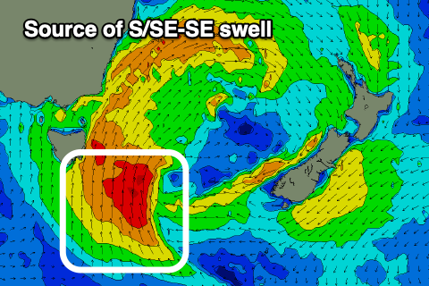
It's a mix of mid-period swell and localised windswell, but we should see moderate-large levels of S/SE swell peaking early tomorrow, easing steadily through the day ahead of plenty of fun sized SE swell through the end of the week and weekend, followed by E swell next week.
This will be thanks to the low moving further east, projecting a fetch of strong SE winds through our swell window, then stalling across New Zealand while restrengthening. A persistent fetch of strong E/SE winds are due to be generated off the tip of the South Island from Wednesday through Thursday, generating some fun E/SE swell for the weekend.
Size wise, tomorrow morning should be in the 6ft+ range out of the S/SE (8ft deep water reefs) along with gusty S/SW tending S/SE winds into the early/mid afternoon.
Wednesday looks to still be 4-5ft out of the SE, then likely not dropping below 3-4ft through the end of the week.

Unfortunately winds will deteriorate though with Wednesday morning seeing good SW offshore winds, tending SE through the day and then strengthening S/SE-SE winds Thursday and Friday that may be S/SW early each day (most likely). Try southern corners with this combo.
There'll still be plenty of E'ly swell into the weekend from the fetch off New Zealand, with more to come into next week as the low starts to feed into a deepening low in the Bight, generating strengthening E/NE winds through the Tasman Sea.
This will bring building levels of E/NE swell next week, moderate + in size and with favourable winds after weekend NE breezes. This is likely to move around a little so check back here on Wednesday for a clearer idea on a very active outlook.