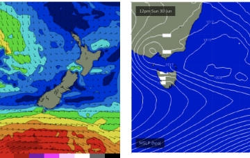
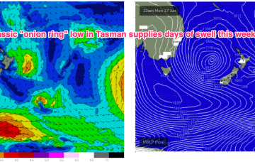
By Sun morning we should see a low NW of Tas with a secondary system further away in the Tasman towards the South Island.
Primary tabs
/reports/forecaster-notes/eastern-tasmania/2024/06/26/small-the-weekend-more-robust-outlook-sun
freeride76
Wednesday, 26 June 2024
/reports/forecaster-notes/eastern-tasmania/2024/06/24/mostly-tiny-week-some-minor-ne-windswell-later
freeride76
Monday, 24 June 2024
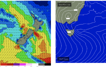
Models have been flip-flopping but we are starting to have some confidence on a frontal system and the cut-off low entering the Tasman this weekend or early next week.
/reports/forecaster-notes/eastern-tasmania/2024/06/21/sat-last-day-the-swell-small-bits-and-pieces
freeride76
Friday, 21 June 2024
Winds may shift more N’ly through Bass Strait and up towards the South Coast later Thurs into Fri, bringing a spike in NE windswell.
/reports/forecaster-notes/eastern-tasmania/2024/06/19/extended-swell-event-eases-the-weekend-not-much
freeride76
Wednesday, 19 June 2024
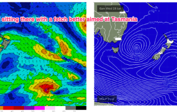
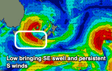
Winds feeding into the southern flank of the low are well aimed at Tasmania and we’ll see more strong SE tending E/SE swell tomorrow.
/reports/forecaster-notes/eastern-tasmania/2024/06/17/lots-surf-the-se-ese-low-hovers-in-the-tasman
freeride76
Monday, 17 June 2024
That low is expected to slowly drift and dissipate through the week, maintaining elevated surf through to mid-week with a very slow easing trend in place and a pulse of E/SE swell Thurs.
/reports/forecaster-notes/eastern-tasmania/2024/06/14/s-se-swells-becoming-very-large-over-the
freeride76
Friday, 14 June 2024
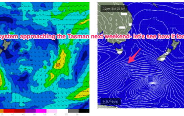
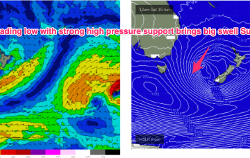
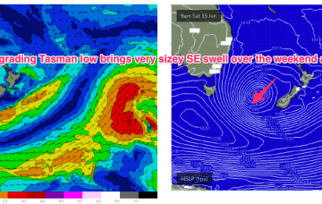
A secondary front pushing into the Tasman coalesces with a deepening low near New Zealand and the system then retrogrades back into the Tasman over an already active sea state delivering powerful E/SE swell before taking up residency in the Central Tasman for a few days next week with a slow, slow easing in big swells expected.
/reports/forecaster-notes/eastern-tasmania/2024/06/12/slow-moving-tasman-low-sends-heaps-sizey-se
freeride76
Wednesday, 12 June 2024
Into the weekend and the low retrogrades back towards Tasmania over the weekend with plenty of size expected from the S/SE-SE.
/reports/forecaster-notes/eastern-tasmania/2024/06/10/tons-south-swell-large-the-south-east-the
Craig
Monday, 10 June 2024
The coming period will be dominated by south and then south-east swell energy.
/reports/forecaster-notes/eastern-tasmania/2024/06/07/small-east-swell-the-weekend-followed-south
Craig
Friday, 7 June 2024
There should be some fun small east peaks on the weekend, with some larger localised south swell for next week.

/reports/forecaster-notes/eastern-tasmania/2024/06/05/small-pulses-e-swell-stronger-s-swells-ahead
freeride76
Wednesday, 5 June 2024
Sunday is a different story as a strong front joins the developing low, bringing a fresh S’ly flow and a building S swell in the a’noon.
