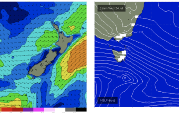
A slightly stronger NE windswell looks on track for Fri into Sat as pre-frontal winds freshen.
Primary tabs
/reports/forecaster-notes/eastern-tasmania/2024/07/19/nothing-major-the-radar-some-small-ne-windswell
freeride76
Friday, 19 July 2024
/reports/forecaster-notes/eastern-tasmania/2024/07/17/strong-s-swell-spike-tomorrow-then-low-moves
freeride76
Wednesday, 17 July 2024
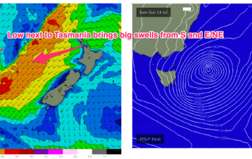
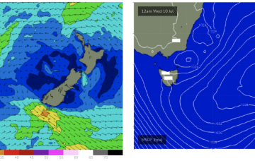
The low next to Tasmania and proximate fetch will generate a strong spike in S swell tomorrow before it quickly moves away with following fronts now looking less aligned for S swell production.

/reports/forecaster-notes/eastern-tasmania/2024/07/15/large-stormy-swells-couple-days-winds-slowly
freeride76
Monday, 15 July 2024
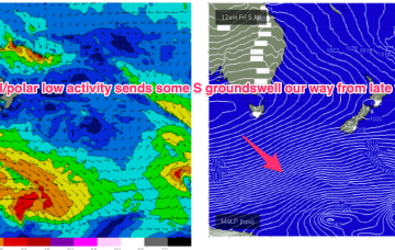
We have a deep low (985hPa) adjacent to Tasmania and another attached low centre further E in the Tasman with the long E’ly infeed into this complex low gyre focussed near the west coast of the North Island aimed up at Tasmania.

/reports/forecaster-notes/eastern-tasmania/2024/07/12/large-swells-and-strong-winds-expected-low
freeride76
Friday, 12 July 2024
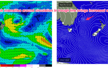
The circulation in the trough line has increased wind speeds in the fetch as the air mass moves from high to low pressure. As a result we’ll see an increase in wave heights and period through tomorrow. The return flow from the deepening low as it tracks southwards towards Tasmania in the trough line will see mod/fresh S/SW winds set in after an early W-W/NW.
/reports/forecaster-notes/eastern-tasmania/2024/07/10/active-period-ahead-sizey-swells-the-ene-then-s
freeride76
Wednesday, 10 July 2024
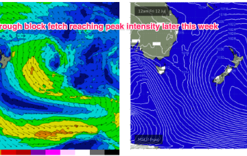
This anchored trough fetch, or trough block pattern is favourable for swell production for almost the entire Eastern Seaboard and will come with mostly offshore winds until the weekend brings a more S’ly biased flow to Tasmania. We’ll see remnants of a small low at the terminus of the trough get captured over the weekend and generate S swells from the return flow of a regenerated low.
/reports/forecaster-notes/eastern-tasmania/2024/07/08/quality-ene-swells-building-later-week-good
freeride76
Monday, 8 July 2024
An inland trough eventually clears the coast later Tues or Wed and the broad E’ly infeed into the trough transforms a typical but out of season tradewind fetch into a more broadscale “trough block” feature which will send swell to most of the Eastern Seaboard.
/reports/forecaster-notes/eastern-tasmania/2024/07/05/small-s-pulses-over-the-weekend-plenty-energy
freeride76
Friday, 5 July 2024
This looks to set-up as the clearing trough Mon sets up a long N-S oriented line in the Tasman to Coral Seas and focusses a long E’ly tending E/NE fetch through this vast area focussing nicely into the NETas swell window around a small low at the end of the trough.
/reports/forecaster-notes/eastern-tasmania/2024/07/03/small-s-pulses-over-the-weekend-replaced-some
freeride76
Wednesday, 3 July 2024
A low in the Tasman is moving north away from the East Tas swell window with some strong, zonal frontal activity tracking through the deep southern ocean. An active July map, with more action ahead next week.

/reports/forecaster-notes/eastern-tasmania/2024/07/01/fun-pulses-s-se-swell-week-improving-winds
freeride76
Monday, 1 July 2024
Although S’ly winds will be problematic until Fri there’ll some swell to play with as low pressure remains in the Tasman, with a slingshot fetch expected as the low moves N during the week and some sideband energy for NETas.
/reports/forecaster-notes/eastern-tasmania/2024/06/28/north-followed-south
Craig
Friday, 28 June 2024
A deepening mid-latitude low moving across us will bring some northerly windswell followed by short-range southerly energy.