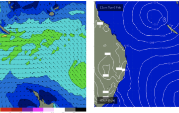
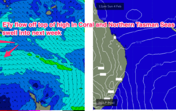
The E’ly-SE’ly fetch gets reinforced later Sat by a new high pressure ridge squeezing up against a tropical low hovering NW of New Caledonia so we should see surf start to build again through Sun.
Primary tabs
/reports/forecaster-notes/central-queensland/2024/02/09/surf-pattern-continues-through-next-week
freeride76
Friday, 9 February 2024
/reports/forecaster-notes/central-queensland/2024/02/05/lots-surf-ahead-coral-sea-remains-active
freeride76
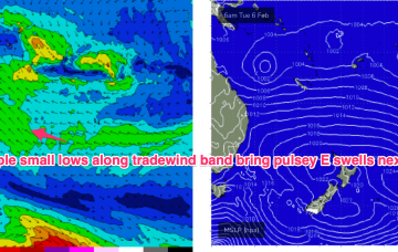
Monday, 5 February 2024
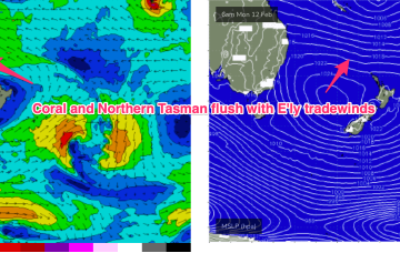
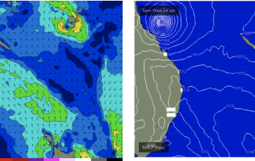
A semi-stationary area of low pressure in the Coral Sea is anchoring a broad trade-wind flow with an extended tradeswell event ahead.
/reports/forecaster-notes/central-queensland/2024/02/02/active-coral-sea-finally-brings-extended-surf
freeride76
Friday, 2 February 2024
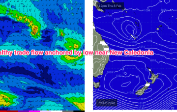
The low sits semi-stationary new New Caledonia from today, anchoring a tradewinf flow in the Coral Sea that will provide an extended period of fun waves for CQ, especially spots open to swells through the Breaksea Spit- Capricorn Channel swell window.
/reports/forecaster-notes/central-queensland/2024/01/31/extended-surf-pattern-incoming
freeride76
Wednesday, 31 January 2024
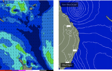
The monsoon remains active with a small sub-tropical low movingE off the QLD coast where it may undergo further development In the Coral Sea in the medium term. A typical summer tradewind band cradles this low next week with plenty of E quadrant swell expected, favouring the sub-tropics for size.
/reports/forecaster-notes/central-queensland/2024/01/29/small-fun-surf-ahead
freeride76
Monday, 29 January 2024
A northwards moving trough brings a SE-E/SE flow into the CQ swell window north of Fraser later Wed with small E/SE swells developing Thurs.
/reports/forecaster-notes/central-queensland/2024/01/26/tinyflat-in-the-short-term-tropics-still
freeride76
Friday, 26 January 2024
No change to the short term f/cast. TC Kirrily has now crossed the NQ coast leaving a light N’ly flow in the Coral Sea and no real swell generating winds. That will see tiny/flat surf over the weekend and extending into next week.
/reports/forecaster-notes/central-queensland/2024/01/24/couple-more-days-really-fun-surf-tc-kirrily
freeride76
Wednesday, 24 January 2024
We’ll see fun waves peak through Thurs morning before easing into Fri and becoming tiny over the weekend.
/reports/forecaster-notes/central-queensland/2024/01/22/fun-sized-swells-associated-tc-kirrily-week
freeride76
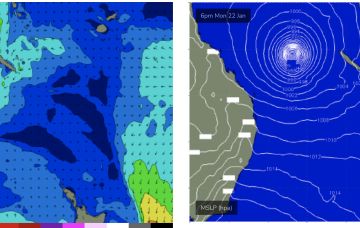
Monday, 22 January 2024
All the headline action is in the tropics with a cyclone (TC Kirrily) expected to form within the next 24-36hrs in the monsoon trough NE of Cairns. A coastal crossing in N.QLD now looks the most likely outcome with some surf potential for the CQ region, at least in the short/medium term.
/reports/forecaster-notes/central-queensland/2024/01/19/cyclone-swell-likely-next-week
freeride76
Friday, 19 January 2024
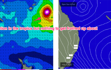
All eyes on the Coral Sea where this tropical low is expected to deepen into a tropical cyclone that is expected to be slow moving.
/reports/forecaster-notes/central-queensland/2024/01/17/small-in-the-short-run-probable-cyclone-in
freeride76
Wednesday, 17 January 2024
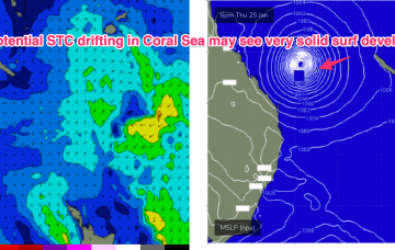
In the South Pacific we have a retrograding trough of low pressure along a tradewind band and finally,the Northern Australian Monsoon (NAM) is in full swing and a tropical low is expected to bud off the end of the monsoon trough into and over the weekend, with a reasonable likelihood of cyclogenesis into next week. Still plenty of uncertainty there over intensity, track and surf potential but at least some model runs are starting to look favourable.