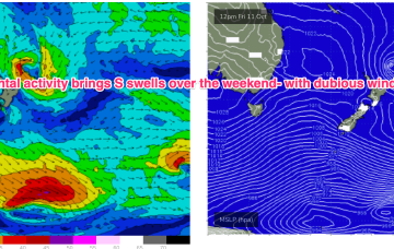
We’re still looking at a fairly bland synoptic pattern with a weak, troughy environment in the Tasman, undergirded by zonal frontal activity well to the south. Some modest frontal activity pushes through late in the week with a developing N’ly flow on Sun set to provide some NE windswell.
Primary tabs
/reports/forecaster-notes/sydney-hunter-illawarra/2024/10/30/grovel-days-ahead-low-energy-outlook
freeride76
Wednesday, 30 October 2024
/reports/forecaster-notes/sydney-hunter-illawarra/2024/10/27/weak-troughy-pattern-in-the-tasman-week
freeride76
Monday, 28 October 2024
High pressure drifts into the Bight but weakens as the week progresses with a weak high cell budding off and moving NE into the Tasman. The result is a weak, troughy pattern in the Tasman and inland- unstable but not very surfy.
/reports/forecaster-notes/sydney-hunter-illawarra/2024/10/24/energy-the-s-over-the-weekend-improving
freeride76
Friday, 25 October 2024
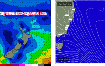
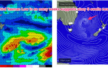
A complex but disjointed low has formed in the Tasman with diffuse centres off the North Coast and Tasmania/Gippsland coast. We’ll see various S swells generated by proximate and distal fetches from this system over the weekend and into next week.

/reports/forecaster-notes/sydney-hunter-illawarra/2024/10/22/troughy-tasman-looks-deliver-more-low
freeride76
Wednesday, 23 October 2024
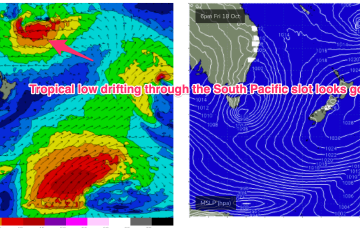
Lingering troughiness in the Tasman may see yet another low form next week- which would be the 4th successive surface low to form in October. Models are struggling to resolve this complex and unstable pattern so low confidence results.
/reports/forecaster-notes/sydney-hunter-illawarra/2024/10/21/short-the-s-long-the-e-should-be-good
freeride76
Monday, 21 October 2024
The current low located near Lord Howe Island dissipates through today with easing winds along the Eastern Seaboard as a result. Weak pressure gradients then occupy the Tasman through the mid week, offering up good conditions as a long range E swell makes landfall.

/reports/forecaster-notes/sydney-hunter-illawarra/2024/10/18/not-much-over-the-weekend-very-active
freeride76
Friday, 18 October 2024
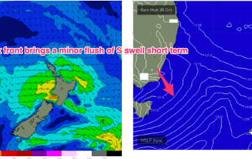
A low is expected to move E of Tasmania o/night and form a broad low pressure trough in the Tasman driving W’ly then S’ly winds along the NSW coast before moving NE as a surface low over the weekend. That will be the second surface low in succession to form in the Tasman and we may yet see a third develop later next week.
/reports/forecaster-notes/sydney-hunter-illawarra/2024/10/15/fun-waves-short-term-next-week-looking
freeride76
Wednesday, 16 October 2024
We still have low pressure roughly due east of the NSW/Victorian border buttressed by high pressure near New Zealand. It’s not a very strong system but we did see a little flare up on the southern flank o/night into this morning before the system began to dissipate, although it is expected to linger in the central Tasman
/reports/forecaster-notes/sydney-hunter-illawarra/2024/10/13/toned-down-forecast-fun-waves-ahead-nice
freeride76
Monday, 14 October 2024
Overall though, the surf potential has been toned down as windspeeds remain limiting and the system dissipates as it lingers in the Tasman. Local winds also take a couple of days to improve.
/reports/forecaster-notes/sydney-hunter-illawarra/2024/10/11/bog-standard-weekend-plenty-potential
freeride76
Friday, 11 October 2024
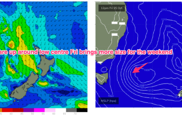
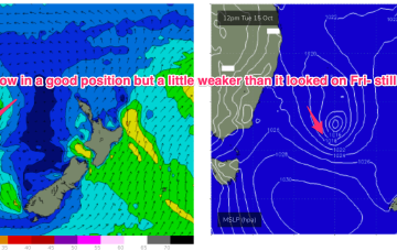
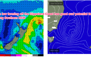
The trough looks to rapidly deepen into a broad surface low off the Far South or Gippsland Coast o/night Mon into Tues. There’s still model divergence over the strength and position of this low which will have material impacts on surf size and local winds so stay tuned for updates over the weekend and on Mon.
/reports/forecaster-notes/sydney-hunter-illawarra/2024/10/08/few-bits-and-pieces-mostly-unfavourable
freeride76
Wednesday, 9 October 2024
The current S swell will ease through tomorrow with a pair of cold fronts passing into the Tasman Thurs/Fri ahead of another trough and high pressure ridge. In short, we’ll see pulses of S swell but favourable winds will be short-lived.