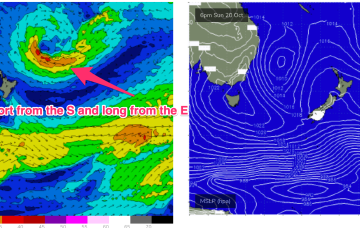
S groundswell is still on the radar as a slow moving polar low tied to Fridays front skirts the southern edge of the swell window, over the weekend.
Primary tabs
/reports/forecaster-notes/south-east-queensland-northern-new-south-wales/2024/11/06/ne-windswells
freeride76
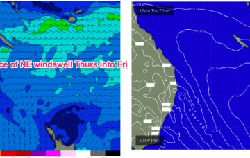
Wednesday, 6 November 2024

/reports/forecaster-notes/south-east-queensland-northern-new-south-wales/2024/11/04/nlies-and
freeride76
Monday, 4 November 2024
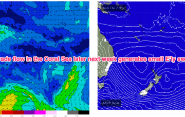
Very quiet across the entire spectrum of the East coast swell window at present. Weak high pressure near New Zealand is being shunted away by another weak high cell moving into the Tasman overnight into tomorrow. Troughiness continues with a slow moving trough line semi-stalled across the MNC this week.
/reports/forecaster-notes/south-east-queensland-northern-new-south-wales/2024/11/01/mostly-nlies
freeride76
Friday, 1 November 2024
A shallow troughy change Mon looks to stall south of the MNC on Mon. If that current outlook holds we’re looking at a working week of N’ly winds and patches of NE windswell.
/reports/forecaster-notes/south-east-queensland-northern-new-south-wales/2024/10/30/lots-nlies-and
freeride76
Wednesday, 30 October 2024
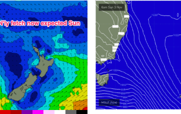
Some modest frontal activity pushes through late in the week with a developing N’ly flow on Sun set to provide some NE windswell. Looks like more of the same next week with a fluctuating trough remaining semi-stalled along the NSW coast bringing mostly N'ly winds and small, weak swells.
/reports/forecaster-notes/south-east-queensland-northern-new-south-wales/2024/10/28/lacklustre-spring
freeride76
Monday, 28 October 2024
High pressure drifts into the Bight but weakens as the week progresses with a weak high cell budding off and moving NE into the Tasman. The result is a weak, troughy pattern in the Tasman and inland- unstable but not very surfy.
/reports/forecaster-notes/south-east-queensland-northern-new-south-wales/2024/10/25/s-swells-in-the
freeride76
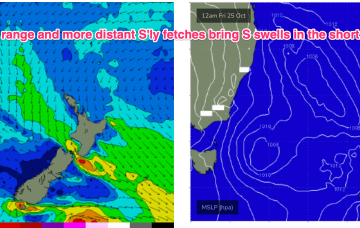
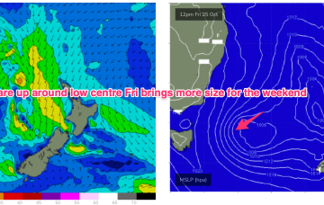
Friday, 25 October 2024
A complex but disjointed low has formed in the Tasman with diffuse centres off the North Coast and Tasmania/Gippsland coast. We’ll see various S swells generated by proximate and distal fetches from this system over the weekend and into next week.
/reports/forecaster-notes/south-east-queensland-northern-new-south-wales/2024/10/23/troughiness-in
freeride76
Wednesday, 23 October 2024
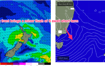
That will see a S wind change and some, windy but sizey S swells through the end of the week into the weekend. Lingering troughiness in the Tasman may see yet another low form next week- which would be the 4th successive surface low to form in October.
/reports/forecaster-notes/south-east-queensland-northern-new-south-wales/2024/10/21/short-the-s-and
freeride76
Monday, 21 October 2024
The current low located near Lord Howe Island dissipates through today with easing winds along the Eastern Seaboard as a result. Weak pressure gradients then occupy the Tasman through the mid week, offering up good conditions as a long range E swell makes landfall.
/reports/forecaster-notes/south-east-queensland-northern-new-south-wales/2024/10/18/ordinary-start
freeride76
Friday, 18 October 2024
A low is expected to move E of Tasmania o/night and form a broad low pressure trough in the Tasman driving N-NW’ly then S’ly winds up the coast before moving NE as a surface low over the weekend. That will be the second surface low in succession to form in the Tasman and we may yet see a third develop later next week.

/reports/forecaster-notes/south-east-queensland-northern-new-south-wales/2024/10/16/small-blend
freeride76
Wednesday, 16 October 2024
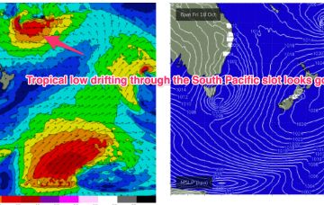
In the tropics a trough deepening between Vanuatu and Fiji forms a broad surface low which tracks southwards through the wide open South Pacific slot between the North Island and tropical island chains, generating some tasty E’ly swell next week.