Shades of Black

A fortnight ago I posted an analysis article on the peculiar early winter weather systems surrounding the continent. In the article, I made a prediction on the coming fortnight of surf, noting that we'd passed the winter solstice and the typical frontal systems were yet to be seen in the Southern Ocean, while the short term outlook continued this trend.
Meanwhile, the charts were hinting at an out-of-season synoptic setup off the East Coast, supplying a run of sizable swell out of the east.
From 22nd June:
“Similar to other setups we've already seen this year, easterly trades extending out into the western Pacific Ocean should produce a prolonged easterly swell event from late next week, into the following week, biggest across south-east Queensland and northern NSW, grading smaller further south.”
While the models swayed back and forward as the event neared closer, what initially looked to be just a strong low tucked in behind the shadow of New Zealand, started to transform into a setup that would favour all locations from Queensland to Tasmania's east coast.
Most east swells of note are products of the trade wind belt, which fluctuates in strength through summer and autumn. While forecast to arrive from the same direction, this swell had an entirely different synoptic setup. And while it was rare, it wasn't entirely unheard of, though it'd been five years since we'd seen a swell created from a similar event.
Winding back to June 2016, the Black Nor'Easter storm and swell event brought huge ridable waves to the East Coast.
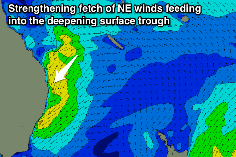
The catalyst for that event was a deep infeed of east-northeast winds spanning from Fiji to almost the East Coast, being gradually squeezed by a deepening zipper-like trough line running along the coast. This saw north-east winds gradually strengthen on top an active and expansive sea state, with embedded lows producing stronger burst of gale-force winds.
The swell rose rapidly and once the trough moved offshore, winds swung, cleaning up large, ruler-edged 15ft sets - occasionally even bigger - during the first day of the swell, the size then tapering through the week.
The setup responsible for the current swell is very similar in structure, though not quite as strong as the July 2016 version. Also, the 'zipper line' of troughs sat further offshore, more towards the central Tasman Sea, which reduced the fetch and subsequent size impact.

The longevity of the current swell is due to the strength of the high pressure system sitting over New Zealand, registering 1040hPa, which, at that latitude, is usually only seen in summer. Combined with the cut-off low sitting further east in the South Pacific Ocean (see image below) and the zipper line to west, the high was being squeezed on both sides while seemingly held in place.

Just as the high pressure system is inching eastward, so too is the trough line. It's very slowly pushing the whole swell-generating setup further towards New Zealand, and this is the key to the longevity and quality of the swell event. While at times it overpowered some beachbreaks, it's been mostly accessible with pumping surf in the six foot range across southern NSW, bigger in select areas of northern NSW and south-east Queensland.
This satellite loop from yesterday shows the trough line (cloud east of it and clear to the west) and an embedded low pushing slowly east, towards New Zealand as the sun sets from the east.
Satellite loop courtesy of the Bureau of Meteorology
I've posted a gallery from various sessions across the Sydney region here, but below are a few B-sides that didn't make the top twenty cut.


Saxon Reber racing for cover


Saxon Reber styling

Eduardo Mattei checking ahead of the next section
Comments
Interesting what the beaches (don't) handle here, this one was way better.
My arms hurt just thinking of that sweep haha.
https://www.swellnet.com/reports/forecaster-notes/south-east-queensland-...
Yeah that one's gonna come in more north-east and lower period. Love those ones as well!
On the money Craig North/East swell in the 4 to 7ft range
here since last Firday with light to moderate westerly winds!
thanks Craig, I was calling mini black-nor-easter set-up as soon as I saw the stalled N/S trough line and monster high.
thank God, it wasn't a straight redux.
this one has improved the banks.
Yep, me and my mates were also, even back maybe three weeks ago when it was toying with it a little. Had more the south-west to north-east tilt in those way early runs though.
Really? Not around my traps Steve, although haven't done a full recon still but initial views are banks are still dog turd around here.
Beautiful pics Craig.
What is the difference between a zipper line and a trough block?
About eight schooners.
haha was thinking along those lines so let's just make it a six pack, and call it a zipper block?
Gold
craig why is wa so west in its swells these days ?they never use to be that angle like 275deg is wild used to beg for 235.
It's because of all these mid-latitude lows and fronts instead of polar systems. It's resulting in lots of west swell for you guys, South Australia and Victoria.
Why they keep popping up and we're not seeing the westerly storm track fire up south-west and south of the country I still can't get to the bottom of. I'm trying though.
Another interesting analysis Craig. Cheers. You remind me of this American TV weatherman we had over here in the 90's who was actually a meteorologist. His name was Augie Auer. He used to introduce various meteorological terms and then use them regularly. My favourite (if my memory serves me right) was the "Barometric Leaf" Buggered if I can remember what that is but it was a goodie.
After a few years the powers that be at TV3 decided that his brand of weather forecasting was too taxing on the average New Zealander's intellect so they replaced him with a good looking young woman. He died about ten years ago of a heart attack and is still sadly missed by weather nerds such as myself. RIP Augie Auer.
How good was the TV3 weather. My folks preferred the news on 1 but I used to make them switch to 3 for the weather. Angie was a wealth of information.
The moving isobars animation probably taught kiwi surfers a hell of a lot about reading weather maps and by default swell forecasting.
*Baroclinic Leaf - It's the shape of the cloud shield in a deepening mid-latitude low. Not an Augie-ism, but he did use it often.
Another one was "Stovepipe Low", meaning the low was stacked through the atmosphere (the surface, mid-level and upper lows right over one another).
And yeah, Augie knew his shit. Ex-MetService man, and his legacy lives on here.
Interesting guys, good stuff!
thats awesome.
is that similar to the occluded low that Pat Caldwell from NOAA used to reference all the time when talking about Aleutian lows?
It's generally a slow-moving cut-off low.
https://en.wikipedia.org/wiki/Cut-off_low#:~:text=A%20cut%2Doff%20low%20....
Love the photos. 2016-immense joy forever imprinted in my core memory.
Just looking at the outlook to the 19th of July and the ECMWF ensemble forecast charts have a more favourable low pressure anomaly developing south of the Bight, stretching into the Tasman Sea, but this general alignment points to a continuation of mid-latitude lows.
If that anomaly where angled more diagonal, ie south-west to north-east we'd be expecting polar fronts to push up into Victoria, but with it's more zonal (west to east) alignment we can expect mid-latitude lows to continue and actually strengthen.
Over in the Indian Ocean we're looking a a high pressure anomaly which isn't ideal for Indo or WA.
Is that good for Shippies Craig? Or too close for those Northerly winds?
All too west (the swells).
Just wondering....did it really hit 15ft plus? I haven't seen any photos or any hype close to that as yet.
Looking forward to being corrected.
Put a size on this..
https://www.swellnet.com/news/swellnet-dispatch/2016/06/17/size-matters
Hang on, I misread...I thought you were calling this swell hitting 15ft, not the 2016 swell! Apologies.....size-wise, though, I reckon that wave is in the vicinity of 15ft from the safety of the lens and it could be popping 18ft if it was about to land on your head. Definitely triple-faaark material.
Aghh I see yeah this swell in Sydney was mostly 4-6ft with the odd bigger cleanup.
Huey : "Craig ziplines so high, I use him as my eye in the sky.
If Craig needs to measure up, then we Qldurrz won't be afraid to call in the Colossal 20ft.
Qldurrz Sat' news...NovaSAR-1
Poms have loaned Oz a pair of Big Brother Xray Spex...Now Freely available to Oz "Researchers"
X Ray Spex are capable of penetrating thru Cyclones to look inside Huey's drawers.
Huey has nominated Surf God Craig from the Swellnet Institute for Surf Excellence & rowdy stuff.
https://www.brisbanetimes.com.au/national/csiro-shares-new-eye-in-the-sk...
Submissions for Swell Events 8th Oct 2021 -Oct 2022..(Lay days included...Bummer!)
Sign here Craig...your deadline is ticking away fast... 61 days 15 hours 1 min. & 5.4.3.2.1 secs (Approx)
https://opal.novasar.csiro.au/
Yes! Of course it's real....GO FOR IT Craig...