Forecast: Quiksilver Pro France

We're back into the ocean, to the somewhat less predictable but more captivating waves and winds of the Quiksilver Pro France (kicking off this Thursday). The pros have been scoring some heavy warm up sessions the last two days, including this insane make by Jeremy Flores yesterday.
The event window is full of quality swells and generally favourable winds until later when things get large and windy. But by then the organisers will have finished the event off.
The North Atlantic Ocean is especially active at the moment, with a low swinging in from the west-northwest, bringing a building mid-period W/NW swell overnight tonight, which will ease off steadily through tomorrow.
 Come Thursday, the first day of the waiting period, winds should be offshore from the SE and with easing 3-5ft waves. Afternoon sea breezes will create bumpy conditions though they shouldn't reach too much strength.
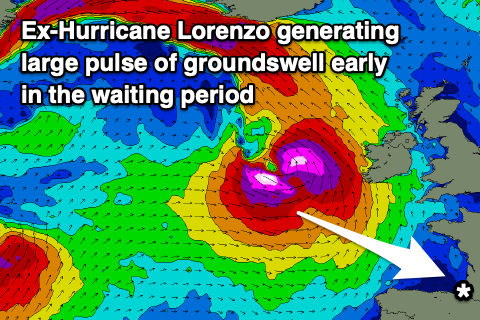
Friday unfortunately looks onshore and poor as another front clips the region, along with a building W'ly groundswell. The groundswell will originate from ex-Hurricane Lorenzo, which is currently positioned halfway between Morocco and the Unites States. Lorenzo is a Category 5 system and the easternmost hurricane ever measured at this strength in the Atlantic Ocean. It's forecast to be swept into the storm track and north-east towards France over the coming days.
The remnants of Lorenzo will be strong but they'll track quickly through France's swell window, with the tail of the low being most favourable. A burst of gale to severe-gale W'ly winds should build rapidly on Friday to 6-8ft by late in the day from a small morning base, easing from 6ft+ Saturday morning light morning SE winds ahead of NW sea breezes.
Sunday looks to be another lay day with onshore winds as a front moves in from the west, though a new pulse of W/NW groundswell will build into the afternoon, peaking on Monday to 4-6ft, generated by a strong front hooking up through the North Atlantic later this week.
Winds won't be great as they'll swing cross-shore from the N/NE on Monday morning for the swell, then N/NW into the afternoon creating another bumpy but contestable day. Tuesday will see better E'ly offshore winds with the swell easing back from 4-5ft.
Later in the day we may see a large, long-period W'ly groundswell moving in, produced by an intense low forming off Newfoundland and projecting east. The models diverge a little on the strength of this low and the local winds, but we'll provide future updates on this in the comments below.

Comments
Way better than the rubbish we've got around the northern rivers at the moment. Losing my mind
Lorenzo..
Thanks Craig, only place to do a contest forecast I can find !
My pleasure.
History repeating - a large hurricane went through on pretty much the same path when we were over there for the 2017 Quik Pro as well, just after the comp had wrapped up, if I recall correctly. 8-10 foot closeouts with three-foot thick lips from one end of the beach to the other. It was terrifying and mesmerising at the same time.
Cheers Craig. Bring on a comp in the ocean!
x 2