Long Wave Trough on Australia/Fiji tour

 It's been an unusual start to winter across most of the country with persistent high pressure blocking the southern states from cold, snow-bearing weather systems. This has helped create milder weather across the country with most cities seeing their warmest and direst starts to winter on record.
The Bureau of Meteorology notes that parts of Australia have seen pressure readings of 1039hPa, way above the average of 1013 for this time of year, and are labelling it a one-in-ten-year event.
While not good for generating large winter storms across Southern Australia, Victoria and Tasmania, it has helped provide extended runs of excellent conditions across the southern states, with Western Australia seeing some of the best surf for a long time over the past couple of months.
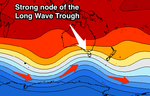
This brings us to the first real significant polar frontal progression of the winter, forming later this week in the Southern Ocean under the effects of a strong node of the Long Wave Trough.
 This node is currently strengthening over the Bight and will move slowly east over the coming days, ideally through Victoria's swell window and then Fiji/New Zealand's swell window.
We'll see the first frontal system under the influence of the Long Wave Trough developing this afternoon, south-southwest of Western Australia on the polar shelf. An expansive and broadening fetch of gale to severe-gale W/NW winds will create a large active sea state.
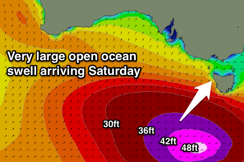
This secondary storm will project stronger storm-force W/SW winds on top of the active sea state and towards Victoria, resulting in quicker than normal wave growth and the production of a large long-period SW groundswell for Saturday across Victoria, South Australia and Tasmania.
The Surf Coast should see 6-8ft+ surf, with 6-8ft surf off Victor Harbor and maxing 6ft+ surf inside Tassie's South Arm at Clifton Beach.
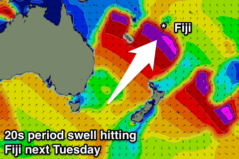 With the strong node of the Long Wave Trough continuing east through Friday we'll see the final stages of the secondary low generating storm-force (50kt winds) in Fiji's, New Zealand's and even (to a slight degree) the East Coast's swell window. The swell is expected to arrive Tuesday morning across Cloudbreak with peak periods to 20s, building to the 10ft range into the afternoon, while a similar sized mid-period swell will arrive ahead of this Sunday, produced by a strong low in the Tasman Sea.
With the Long Wave Trough slipping east into the weekend we'll see a ridge of high pressure moving in Saturday, squeezed by a low off WA's South Coast, producing excellent offshore winds across most southern locations.
Weak E/SE trades will also create great waves in Fiji, while Raglan may see variable breezes as the swell peaks Monday morning.
Comments
"It's been an unusual start to winter across most of the country with persistent high pressure blocking the southern states from cold, snow-bearing weather systems. This has helped create milder weather across the country with most cities seeing their warmest and direst starts to winter on record.
The Bureau of Meteorology notes that parts of Australia have seen pressure readings of 1039hPa, way above the average of 1013 for this time of year, and are labelling it a one-in-ten-year event.
While not good for generating large winter storms across Southern Australia, Victoria and Tasmania, it has helped provide extended runs of excellent conditions across the southern states, with Western Australia seeing some of the best surf for a long time over the past couple of months.
This brings us to the first real significant polar frontal progression of the winter, forming later this week in the Southern Ocean under the effects of a strong node of the Long Wave Trough.
This node is currently strengthening over the Bight and will move slowly east over the coming days, ideally through Victoria's swell window and then Fiji/New Zealand's swell window.
We'll see the first frontal system under the influence of the Long Wave Trough developing this afternoon, south-southwest of Western Australia on the polar shelf. An expansive and broadening fetch of gale to severe-gale W/NW winds will create a large active sea state.
This secondary storm will project stronger storm-force W/SW winds on top of the active sea state and towards Victoria, resulting in quicker than normal wave growth and the production of a large long-period SW groundswell for Saturday across Victoria, South Australia and Tasmania.
With the strong node of the Long Wave Trough continuing east through Friday we'll see the final stages of the secondary low generating storm-force (50kt winds) in Fiji's, New Zealand's and even (to a slight degree) the East Coast's swell window. The swell is expected to arrive Tuesday morning across Cloudbreak with peak periods to 20s, building to the 10ft range into the afternoon, while a similar sized mid-period swell will arrive ahead of this Sunday, produced by a strong low in the Tasman Sea.
With the Long Wave Trough slipping east into the weekend we'll see a ridge of high pressure moving in Saturday, squeezed by a low off WA's South Coast, producing excellent offshore winds across most southern locations."
Thats Very interesting Craig .
Will there be any rain in these fronts ?
The farmers are not happy with the dry winter
Unfortunately not Clam, clipping the south-east of the country so only a small bit from that low moving in from the west.
Its habbening!
Appreciate all the forecasts Craig, and these articles - even if no comment left! Just out of interest, there does seem to be a little snowbase on the ground, earlier than usual this year - is it cold nights and machines, or have we managed some decent precipitation of snow as well?
There were a couple of early season dumps but the cover is really thin away from the snow making they've been doing.
the farmers here are not happy with the wet winter.
Another 10-12inches rain here in the last 2 weeks, which adds to the flood less than 3 months ago.
We've had over a metre of rainfall since the start of autumn...........it is fcuking soggy here.
Yeah quite the contrast. I was west a couple of weeks ago praising the clear weather and offshore winds to some of the guys in the water. The farmers were over it and wanted it to breaks. Parched as across the Eyre.
They filled up last year on the back of that - IOD event but.
Thanks craig .
Hows this swell looking for fiji ?
Bad winds here unfortunately for the big south
If you want rain Clam head east mate. No "real" swell to speak of though. Still waiting for a decent Sth.......
Elliedog no thanks . I know some vegetation that wants rain
Citrus?????
Is this swell coming to fiji still ?
Not with any out of the ordinary size. Storm stayed a little west than ideal, so we're probably looking at 6-8ft surf on Tuesday afternoon.