Large swell, limited options

 There's a lot of buzz around the upcoming swell across the East Coast and the excitement is understandable. For Queensland and northern NSW this will potentially be the largest swell event of the last six months. But – and it's a very big BUT - surfing options will be severely limited by local winds.
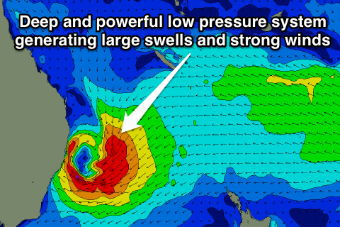
We're into the second week of an extended easterly trade-swell event, and the scenario we've all been waiting for is set to take place later this week. That being a deepening tropical depression slipping south into the trade-flow, squeezing a strong and stationary high pressure system sitting in the Tasman Sea. The effect will be a supercharging of the current trade swell.
The ideal scenario would be to have this development occurring towards New Zealand, which would result in an organised uniform easterly groundswell impacting everywhere from Noosa to Eden.
Unfortunately the depression will form directly off the East Coast which will result in large, chaotic swell, and strong onshore local winds – more so in Queensland and northern NSW. It's a bank buster by any other name.
At present the swell should play out like this: The South East Queensland and Northern NSW coasts will see a steady uptick in easterly trade-swell from today, becoming larger through tomorrow and further into Thursday as a broad fetch of strengthening easterly winds are projected westward towards the Australian mainland.
Now, throw in the aforementioned tropical depression drifting south into warmer than normal sea surface temperatures (as discussed in this article), and we've got a recipe for large and dangerous surf.
 The Quiksilver Pro Snapper Rocks is due to start on February 28th and the talk is already how the bank will fare under this swell. It's currently in good shape, will it survive the onslaught? Swellnet is equally curious how the WSL's two-storey contest structure will hold against the local winds.
The one possible saving grace is that the tropical depression is forecast to slip quickly south resulting in only two days of large surf - Thursday and Friday - before wave heights tail off into the weekend.
Further south, the NSW coast however is likely to see large surf, perhaps around the 10ft range, with favourable offshore south-west winds north of the low's axis and onshore SE winds to the south. This will limit options to protected points and reefs scattered along NSW coast.
Where the lows axis sits is the big question and at this stage it looks to be somewhere off the Mid North Coast but there's still a lot of room for movement regarding the positioning and strength of this dynamic system.
So while there'll be no lack of surf over this coming period, you'll have your work cut out for you trying to find somewhere handling the size and out of the wind. //CRAIG BROKENSHA
Snapper Rocks scaffolding shot by Shayne Nienaber
Comments
That 2 storey tower will be fucked and look at the high tide mark in front of the single story....big tides and swell coming that will be a disaster.
So long, two storey structure... and good riddance.
surely they would have that engineered to withstand strong winds?
For sure it would be eng and heavily braced ..which transfers the load to the footings....sand base with storm surges ...fuck id hate to be the one signing off on it.
Better to start dismantling some of it now.....restart after the weather has passed and work around the clock to get it up...much easier than being in a salvage situation .
I'm pretty sure it's anchored to the rocks at little marli there but I could be wrong, it's been hit by a these sort of things before, I've seen waves running under it all the sand washed away before.
My real question is who the hell pays for this thing? It is massive, the riggers were working all weekend with that big crane there the whole time, I'm pretty sure the structure in the Snapper carpark is a new one, you'd think they'd be trying to pull back costs like these.
But a combination of Strong winds, big tides and huge swell may be too much? Wasn't last year they had containers being washed around?
I can't wait to see that tower coming down haha!
Lots of love for the Comp tower...
Premium marquees have wind resistance around 100km/h...that's single level...without the swell surge.
With paddles they could SUP it ;)
XX Frothing!
Are they kisses Tim? Big kisses?
I can't see any good in this swell event. I don't see what all the excitement is about am I missing something?
I'm seeing a lot of good coming from this swell. It's all a matter of geography.
man that buildings gonna get kicked off as soon as swell hits
Interesting if the structure is anchored to the rocks somehow [how ?]
anyone close by that could have a look ? Launch the drones boys.....
Air cond double decker bus in the carpark would be okay for the judges wouldn't it.
The Joint Typhoon Warning Center have a tropical cyclone formation alert for the system in the Coral Sea..
FORMATION OF A SIGNIFICANT TROPICAL CYCLONE IS POSSIBLE WITHIN A 170 NM RADIUS OF 14.7S 155.3E WITHIN THE NEXT 12 TO 24 HOURS. AVAILABLE DATA DOES NOT JUSTIFY ISSUANCE OF NUMBERED TROPICAL CYCLONE WARNINGS AT THIS TIME. WINDS IN THE AREA ARE ESTIMATED TO BE 25 TO 30 KNOTS. METSAT IMAGERY AT 170500Z INDICATES THAT A CIRCULATION CENTER IS LOCATED NEAR 14.7S 155.3E. THE SYSTEM IS MOVING SOUTH-SOUTHEASTWARD AT 02 KNOTS. 2. REMARKS: THE AREA OF CONVECTION PREVIOUSLY LOCATED NEAR 14.8S 154.5E IS NOW LOCATED NEAR 14.7S 155.3E, APPROXIMATELY 320 NM EAST- NORTHEAST OF WILLIS ISLAND, AUSTRALIA. ANIMATED MULTISPECTRAL SATELLITE IMAGERY DEPICTS A CONSOLIDATING LOW-LEVEL CIRCULATION CENTER (LLCC) WITH IMPROVED CONVECTIVE BANDING. THIS IMPROVED ORGANIZATION IS EVIDENT IN A 162104Z SSMIS IMAGE, WHICH SHOWS DEEP BANDING WRAPPING TIGHTLY INTO A WELL-DEFINED CENTER. A 162321Z ASCAT IMAGE INDICATES A SYMMETRIC WIND FIELD WITH 25 TO 30 KNOTS WINDS. UPPER-LEVEL ANALYSIS REVEALS A MARGINAL ENVIRONMENT WITH MODERATE (15 TO 20 KNOT) VERTICAL WIND SHEAR (VWS) OFFSET BY ENHANCED POLEWARD OUTFLOW. DYNAMIC GUIDANCE INDICATES THAT VWS WILL DECREASE AS THE SYSTEM TRACKS SOUTHWARD. MAXIMUM SUSTAINED SURFACE WINDS ARE ESTIMATED AT 25 TO 30 KNOTS. MINIMUM SEA LEVEL PRESSURE IS ESTIMATED TO BE NEAR 1000 MB. THE POTENTIAL FOR THE DEVELOPMENT OF A SIGNIFICANT TROPICAL CYCLONE WITHIN THE NEXT 24 HOURS IS HIGH.
I recon they should just park it about 1000ks directly off the Sydney coastline..
Lets say for 3/4 days!
One model does look that way inclined ;)
Earthnull site, whats that showing ? site wont load for me.
I'd scull two litres of Balinese tap water to watch that thing blow out to sea...with Pat Parnell riding it down like George Clooney in The Perfect Storm.
B.O.M. - just happen to have 2 diagrams 1 showing an elevated building under normal high tide conditions and 1 under storm surge.
Its a goner.
who cares about the buildings. all we should b e caring about is how good and how big this swell is going to be. we deserve it and let's lap it up. If the buildings go so what!! It's a problem for the organisers. build it on a Hotel roof roof off the beach with sight of the break. HAHAHAHAHA!
Well if Craig is right and it's a bank buster rather than a clean swell, that will wreck the slight progress in deposition that has restored something approaching reasonable banks locally.
Yeah, as I mentioned in another thread, banks across the beaches have been great over the last few swell events. Shame to see them go if they do..
One can only hope EC is right and GFS is wrong.
DWas checking flights for Kirra Thursday but got the flu now so lucky didn't book. Ps skyscanner has the cheapest best flights
Kerry, we're have you been?? You been getting into the great swells and conditions we've been enjoying?
Well if you wanna chase the swell to the Goldie, rob a bank first. Its about $500 plus return without luggage.
Tim, theres flights for $160 on virgin and $130 on Tiger if you are that way inclined
Have to book on Zuji and dohop.com though. 4 other deals from $163
Virgin Australia Airlines in wed morning out friday night
Flight VA500 (Virgin Australia Airlines)
Gold Coast (OOL)-Sydney (SYD)
Gee MF are you Tim's Travel Coordinator!!!
looks like quiky pro might be surfing the Burleigh rock break.....
Actually, if you take a look at the current cam/situation at Snapper/Greeny, you will see there's a huge amount of sand currently deposited way out into the bay (further NE from the current rainbow break area). If the forecast NE swell comes to fruition, then it might just shift this sand into a more beneficial location?
Of course the impending large E/SE swell might chew it out first!!!!
Yeah, noticed that, there's a lot of sand sitting out in the bay there!
Nah, the effect of large swells from the E'n quadrant is to deposit further sand out on those storm bars. That's a well known phenomena. We'll see lefts at Snapper Rocks after this event.
That wide sand comes in close under calm conditions.
Well it's been there for most of Spring and early Summer Steve....couldn't get much calmer conditions than that!!!
Swells building quickly just saw a bomb set break at kirra...very wide of the groyne.
2 skis in the water at Kirra amongst the paddle surfers at present .....already breaking the law .....Tow in etiquette tmoro will be interesting.
Yep just saw that as well, and the sweep is insane!
Very naughty of you Craig to watch CW cam.
Haha, um our Snapper cam looks down to Kirra for 20s or so..
Is the cam adjustable your end, 60 secs would be better at times .
Yeah it is, we'll probably just switch it over to sit on Kirra once it gets bigger tomorrow.
Can we all control it from our computers!!!! ;)
Haha, that would result in anarchy.
Talking of Anarchy what's happened to Sheep dog?? Has he packed up his bat and ball? Hope all is well in the Apple Isle Sheepy
Maybe he's on a plane heading north???
I'm sure Sheepy is alright.
But where is Voldomort ie he who shall not be named......Uplift.
I guess I can see why you'd fly to the Goldy to film. But to surf ?
Just been watching it on the Surfcams......fun by yourself maybe , but so crowded .
Don't get me started on Noosa. Take a look for yourself. What are those people thinking ?
It's a glimpse of the future I guess. To when that Reef fuckwit gets his way and surfing is an Olympic sport with every nation participating.
Enjoy every uncrowned session you get people, cause year on year it's going to get worse.
Sorry to bum your trip this arvo.