New Year fireworks as XXL swell hits Europe

 2014 is set to start with a bang across the North Atlantic with back-to-back XXL swells, the second of which looks to be the biggest swell event in quite some time.
It's been a very active winter season in Europe with a couple of large early season swells, but what's in store early next week is expected to top anything we've recently witnessed.
While large swells are due across Ireland this Friday and Spain/Portugal Saturday they'll arrive with gale-force onshore winds and be mixed in with a lot of localised windswell.
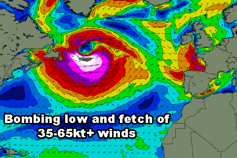
The weather system we're more interested in is a ''bombing low' off Nova Scotia and Newfoundland (dubbed Hercules by melodramatic American weather forecasters) that will engulf the North Atlantic Ocean and head towards Europe. A bombing low is a weather system that drops more than 24hPa in central pressure in less than 24 hours, and this storm will drop from 976hPa down to 944hPa in just over 12 hours, easily reaching this criteria.
The catalyst for this bombing low is a large pool of very cold air in the upper atmosphere along with abnormally high sea surface temperatures in the Gulf Stream (5-6 degrees above average).
These two factors will act together to create an enormous weather system, which, with the help of a strong high pressure ridge to its south, will project a fetch of gale to hurricane-force winds towards Europe.
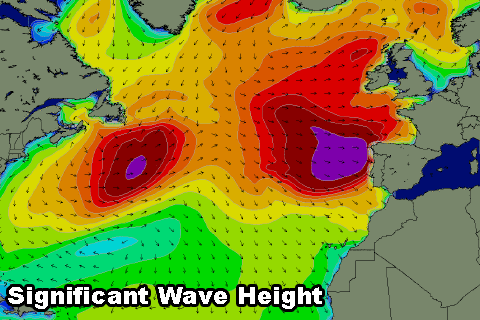 The swell in numbers is amazing, with southern Ireland expected to see 13-15 metres of groundswell at 18 seconds filling in Friday afternoon, while Spain and Portugal should see around 10 metres of groundswell at an astonishing 19 seconds.
Size-wise we can expect anything from 30-40 foot+ waves at exposed locations, but it will be protected spots that are expected to fire under the swell/wind combo.
Will surfers take on Nazare Tuesday?
At the peak of the swell early Tuesday fresh to strong onshore winds will create poor conditions but as the day progresses winds are expected to ease steadily. This will open up a window of better conditions and we may see Garrett McNamara and co. take on the swell in the afternoon.
We'll keep a close eye on it and provide an update on whether there'll be another live webcast from Nazare.
In the meantime watch the storm and forecast charts yourself here for Ireland and Nazare.
Comments
Sounds like a hundred ft !
Yeah caml, with the right location I'd expect some pretty groundbreaking waves off this swell.
TONNTA - wayne Patrick murphy, can you keep us updated on this bombing swell.
Maybe bigger ? 150 ft waves , how many metres at 18 sec ? Really thats bigger than those last swells at nazare where 5-7 m deep water swell . How do they compare craig ? Will mullys handle
This swell looks bigger than the last Nazare swell. Who knows what spots will handle and what other offshore bommies/shoals will appear.
Off County Kerry (south-western corner of Ireland) where the forecasts are holding 15.3m @ 18.6s (we'll probably see periods to 22-23s in reality).
Without going into too much detail our computer model forecasts would have just over 100ft if it were a location without any continental shelf, ie Hawaii or other island location, but taking into account the shelf it has just over 70ft.
craig ive just looked at msw and windguru for mullys and lahinch and those forecasts aren't as large as yours . still massive tho , what sort of shelf does Ireland have and how much of a dampener effect does it have on the big waves of Ireland ?
Ireland actually has quite a wide and shallow shelf that extends for 300km sloping slowly from 100m to about 400m before dropping off to 4,000m (4km).
You can see this below.
And also this swell will be more focussed in to south-western Ireland rather than Mullaghmore which is around the corner. That canyon is quite interesting, I could imagine that focussing swells to certain parts of south-western Ireland while steering it away from others.
Then compare this to Portugal which only has a small shelf, running 20-50km at a depth of 100m or so before dropping off to 4,000m (4km).
You can also see the Nazare canyon which comes in right close to the town of Nazare and focusses those big NW groundswells in.
So looking at these two locations, Ireland would see a lot more energy lost along the shelf due to bottom friction compared to Portugal and hence reduce the size of the swell.
Over here in Aus, the shelf is only about 20-50km wide right around the country besides Bass Strait, the Great Australian Bight and to a lesser extent off Margs, where the shelf is a wider.
Yes am aware of nazare canyon , i studied the effects of why the rottnest bouy reads less than nat and jurien . It was the shelf friction during southerly swells more so than west swells .what about the shelf in s.a. How much swell is reduced say at streaky compared to the bouy at du couedic ? It would be a fair bit wouldnt it ? Rottnest averages a metre less than nat . But jurien reads higher than rott usually
Ok got the maps up and yes ireland has a big shelf indeed. Are there any known big wave breaks in sou west ireland ? I havent heard of any but i will ask fergal about that .
Ok got the maps up and yes ireland has a big shelf indeed. Are there any known big wave breaks in sou west ireland ? I havent heard of any but i will ask fergal about that .he had a bruised leg and couldnt surf last week.
Frothing
Any word on who is heading where? Craig, do you still think Nazare is going to get comfortably more swell than in October? Wind forecast still the same? (strong onshore easing) & peak in Nazare still due early Tue? The wind worries me more than anything. I'm stuck on the idea of maybe going & spectating. I know I shouldn't but.... Couple seats left on the Sat arvo flight out. Long way to go, but if it's on..... well. Oh man...
My heart says go but my head says don't be silly. Craig, just like an idea pretty please if the forecast for Nazare has gotten any better or worse from when you wrote your article.
Cheers, appreciate it.
Go shorey for sure mullys will be best
Swell peaking later Monday now Mitch and with light winds into evening. Strong all day but lighter later. Worth a look for sure!
Mully I know is way heavier Caml but wouldn't Nazare still be the best bet for biggest wave ever surfed? I wouldn't know where to go elsewhere in Ireland. That's what I'd go for, that piece of history. If Garrett & Carlos' waves at Nazare were measured at 70 feet, what do you guys guess it will come in at Monday? Your saying bigger aren't you. I notice Nazare primary swell on Monday is 8.4m which is "only" similar to recent swell events there. It's the chance of the mythical 100 footer that I'd take a punt at going. Would you guys say there's a 20% chance or greater of a 100 footer at Nazare? Man, there's gotta be easier hobbies out there other than storm chasing!
Just thought u might be goofy foot . But yeah guess better check nazare report again just for the record
Shorey well that wind forecast @nazare . Is that light ssw wind ok for riding the mountains there?
That's what I'm worried about. Onshore might make it too bumpy & dangerous, & they won't surf. Might be better to wait for the day a 15m swell is aimed at somewhere with a light offshore. Too many variables with this one to be confident in going. Watch it online instead.
When the waves are that big SD a moderate and even fresh onshore doesn't matter. The strength of the swell will over power this.
Craig is the wind forecast ok for g mac to go
I'd say yes caml, swell is coming in Monday now and peaking late as winds really back off, this is the window!
Yeah ok, going to be some epic sessions going down with this swell. Can't wait to see it all. I wonder if anyone is hitting up SW Ireland. Nazare should be huge, makes me want to see what a 15m swell aimed straight at the canyon would do.
morocco is a good place to be right now. was booked in to go up to the rif mountains on monday, you reckon its worth a change of plans to head down to safi craig?
Craig - not to be too nit-picky but for the purposes of info/discussion - your arrow for Nazare needs some moving north - you're pointing more to Peniche than Nazarre at the moment with Nazare more aligned off the northern tip of the canyon as it reaches the coastline.
I wonder what would be the impact if that canyon actually better aligned for a WNW such as this - scary really
Winds look out of the Sth switching +/- 10 degrees throughout the day which on my observation is cross shore... as you say it won't impede the swell but it does mean there is enough fetch to put a solid chop on the face particularly when you're going 100mph down the face of a god knows how big wave...
Hopefully lots of coverage from all over Euro to come!
Yeah, you're right offshoreozzie, got it pointing just a bit south.
Still looking good for later Monday!
Yeah late Monday or even early Tues (not peak of swell but at this size it doesn't really matter...)
Craig click on the 6pm swell train analysis for the Monday. Needs a colour change.
Ah yes, thanks Mick, that's because the colours match the WAMs and we hit the white threshold with white text.
On the WAMS what happens after Black??
Its not related to XXXL but how big can Mundaka handle??
After black is darkness!!
I was wondering the same about Mundaka! I guess we find out!
Hahaaha it looks blown out in UK. Morocco looks like the place light winds. Also Basque country.
Anyone heard from Visser - this would be his swell to find the 100 footer?
Apparently Jeep were too busy with the Finals of the Australian Polo at Portsea to organise his converted B52 to air drop him into the back of the Canyon at Nazare .
Vis has been quiet lately i hope hes still surfing big waves . I havent seen any latest surf missions hes done lately .
Straight from NOAA facebook.
The SEVIRI RGB Airmass Product shows the strong hurricane force low in the central Atlantic near peak intensity at 1745 UTC 01/04/14. The current 18Z OPC Atlantic Surface Analysis shows the low has weakened from 933 hPa to 943 hPa in the past 24 hours.
A very impressive animated loop of the SEVIRI imagery has been created, and it shows the low developing from 01/03/14 through 01/05/14. Please note it is a 108 MB download. It can be found on the OPC website http://www.opc.ncep.noaa.gov/animated_gifs/seviri_2014_01_05_2136Z.gif
it looks like a wave
Big download indeed, but that is quite incredible Mick.
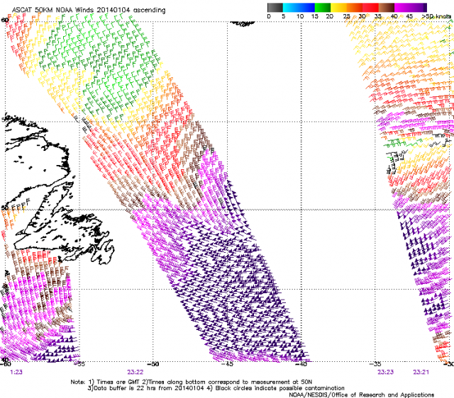
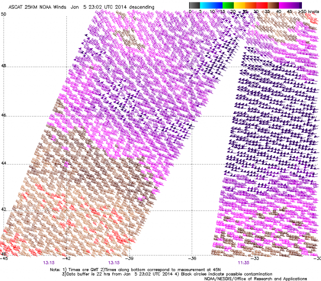
Also check out these satellite passes of the system.
Those purple triangle flags are 50kt+ winds, with the half notch = an extra 5 kts, and the full notch = an extra 10 kts.
So a triangle with a full notch = 60kt winds.
Broader pass:
Zoomed in:
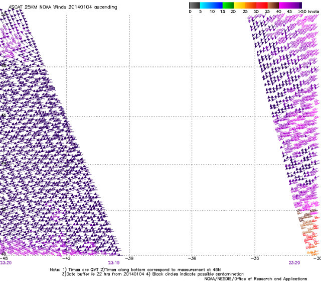
Zoomed in:
Can i learn about wave attenuation due to bottom friction in a language understandable by a simpleton . I want to know how much swell is lost exactly as compared to a deep shore? So i can understand the coast im on at moment .
Not exactly sure on the numbers/exact physics there caml, will have to look into it and get back to you.
Yeah cool craig that be helpful to hear wat experts can tell me. . From wat i have observed it seems rather lots
any live streams from Nazare or somethign?
Buoys off Ireland went up 20 feet to 40 in two hours. Be interesting who makes it where for this swell. The North Shore has bad winds for the whole week so maybe some of the Big wave guys head over..
Oh yeah you got a link for that?
I swear I've seen a link for a live surfcam for Nazare before, not a surfline on either
http://www.ndbc.noaa.gov/maps/United_Kingdom.shtml
if thats the link you are looking for. Otherwise I'm sure someone will post if there is a live feed.
They setup a live webcast for last years swell, not sure if it's going ahead again this time.
http://new.livestream.com/Zon/zonnorthcanyon2013 wasn't this where it was streamed last time if i remember?
Some crazy images starting to come through. Not sure how real this first one is:
Azores:

Azores:

And another from Azores. Photo by Antonio Araujo:
Sussed their facebook and everything, couldn't find a live stream
but cheers for that link mick
Just trying to scope where the " Jump off rock " is , to get out there .....
Could get good with a little Tide ;-)
Haha, just time the sets and you'll be right!
Some serious coastal reshaping in progress.
Sure is reecen... some footage starting to trickle in of sightseers underestimating how big it is -
Wow that is nuts offshoreozzie, I've just reposted it here embedded in the post. Like a tsunami!
So has there been a surfable wave out of this storm system yet?
Or is it all sound and fury?
Looks like Mullaghmore had a couple..
Nothing huge that i've seen yet though.
And I don't think these people would of survived sadly. What were they thinking!
Sorry wouldn't embed so you'll have to watch it here after a 30s add: http://videos.tf1.fr/infos/2014/couple-emporte-par-une-vague-a-biarritz-la-video-amateur-8341354.html
Whoah that vid is heavy!
http://www.thescore.ie/surfing-mullaghmore-1251488-Jan2014/
Picture 4.
Is that you Upskirt?
Doesn't look especially big. Must have been a touch more south in the W/SW direction than forecast (which makes sense, due to the position of the low). Mullaghmore needs more W/NW in the swell direction to benefit size-wise.
http://surf.transworld.net/1000166456/photos/winter-storm-hercules-slams...
JC has instagramed Shane Dorian is heading to Europe. He left on Saturday Hawaiian time. Should see some footage from Billabong
French in the barrel photographer Laurent Pujol (?) instagrammed a pic of Dorian with a paddle board saying the swell did not reach the SW of France Monday but tomorrow will be something to remember.
Talking of paddle boarding that is the last sighting of MV out at Jaws. I hope he was going to fire up the B52, and get over there. Craig are there any Cortes like setups out,in the Atlantic?
Not that I'm aware of Mick, but I haven't really scoured the bathy charts over that way. I'd say if there was we'd already be hearing about it.
Theres a webcam up. Its glassy and big.
http://www.webcam-hd.fr/webcam-belharra.html
Some of the clearest footage of conditions at Nazare I have seen... shows some sense of scale. MASSIVE but can see why no takers..
Do I use standard YouTube embed code? It won't seem to display (shows blank using below - I intentionally removed first and last brackets so you see code
iframe width="640" height="360" src="//www.youtube.com/embed/B6Qu1BEDyJs?rel=0" frameborder="0" allowfullscreen>
Source - http://instagram.com/p/i3imtWnOU4/
Not sure if this is Nazare tues - I believe so

Coverage on blogs beginning so I'll lave it there..
I've just embedded for you, but I have a different editor. Will try figure out how you guys can do it.
Belharra in france, and there was a paddle crew. I know Dorian and Jamie Mitchell got a few.
http://instagram.com/p/i4exPoHOIl/
This paddle wave by Jamie Mitchell at Belharra is probably one of the biggest paddle waves ever. Monster! Imagine paddling down that thing as it continued to draw up getting bigger and bigger. Nuts!
That is a beast. I think he goes down on this and there was another bigger one after.
Awesome effort.
Go jamie ! What a massive drop
Some good news with the couple that were washed off the rocks. Grind has said the man made it to shore 20mins later. His girlfriend is still missing though.
http://www.grindtv.com/action-sports/surf/post/winter-storm-hercules-wre...
http://www.wat.tv/video/couple-emporte-par-vague-biarritz-6l4bn_2exyh_.html