Coastal Creationism - Part 5: Sand dunes and limestone
 Western Australia: How it can be both awesome and wave starved at the same time?
For the last few months I have driven over 15,000 km while exploring much of Australia's West Coast between Cape Leveque, north of Broome, and the Great Australian Bight. Now I'm at the end of my travels I'm going to make a controversial statement:
There's not many good waves on the Western Australian coastline!
Given how exposed it is to the consistent swell trains of the Indian Ocean there are very few good surf spots. Sure, there are good waves - and they are really, really good. My travels have coincided with back-to-back swells and generally good winds so I've been lucky to score many class spots when they are good to epic. But the rarely stated fact is this, the good waves are few and they're a very, very long way between. It's hundreds and hundreds of kilometres between surf spots. With the notable exception of the South West between Capes Leeuwin and Naturaliste, most half-decent surf breaks in WA are a days drive between them. Unless you're a local in the know with a boat, consistent surf breaks accessible from the mainland are the exception rather than the norm.
The West Coast gets more swell and particularly more swell of consequence - that is, long period groundswell with size - when compared to the East Coast. It also gets a lot of wind but the strong offshore land breeze in the mornings helps negate consistent south-westerlies. In my view, the problem with the West Coast is geological. Yes, the geology has blessed WA with untold mineral riches, but it has also got in the way of a lot of good waves. It's the offshore limestone reefs that parallel the coast. Whether they outcrop as islands or sit below the surface, the effect is a barrier to swell.
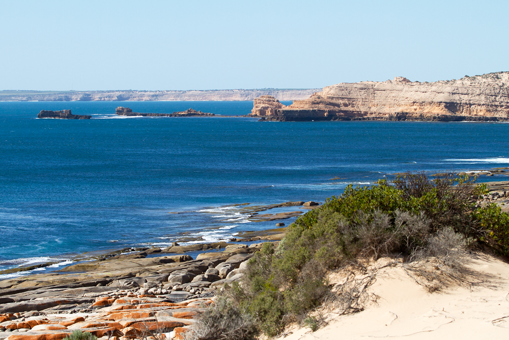
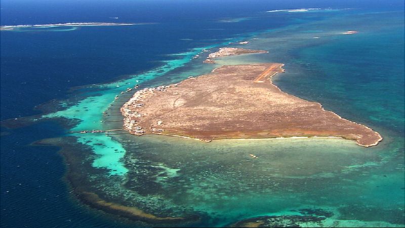 For much of the WA coast south of Carnarvon, the most significant coastal reef forming rocks are limestones formed from geologically young sands. Offshore there are also coral reefs that have contributed to the swell barrier, such as the Houtman-Abrolhos Islands. The reason why there is such widespread limestone reef formation is that the old sand dunes have been 'cemented' into rock hard limestone.
South West WA is the best example; over the past two million years of changing sea-levels, sand dunes have piled high across the coastal plains. When sea level is low, the sand dunes build up. The sands have been rich in carbonate (limestone) shell fragments and these have been partially dissolved by the groundwaters. These waters can then precipitate the carbonate, forming a cement that is almost as hard as concrete. Known as Tamala Limestone, they can be both good for surf, or very bad for surf. In some environments they can form great surfing reefs (eg: Surfers Point and Yallingup) but in many locations the reefs are way offshore and block the swells, or they're too random in structure for a good surfing reef.
The sand dunes that formed these reefs were generally parallel to the coast and laid out across wide expanses of the Swan coastal plains. This means that many of the limestone reefs are actually fossilised sand dunes. With the last sea level rise up to 6,000 years ago, at the end of the ice age, the sand dunes had been transformed into hard limestone. These become partially or completely submerged offshore of the current-day coastline - the modern day reefs.
Unfortunately for surfers, it means the mainland coast from Busselton in the south to Geraldton in the north (and even beyond) is largely blocked from swell. Further north the WA coast is still plagued by offshore reefs blocking swells from reaching the mainland beaches, but these northern reefs are also derived from coral reefs growing in the warmer waters of the Leeuwin Current (eg the Houtman Abrolhos Islands).
The reefs of the Tamala Limestones do occasionally form good waves - and along with the mining boom this has driven strong sales of boats and jet skis in WA for many years. However, most surfers restricted to the mainland could justifiably curse that a coast so blessed with ocean swell sees so little of it turned into good waves. According to the boffins, between 39% and 90% of wave energy is lost for the coast between Yanchep and Bunbury!
Throughout the year offshore oceanographic conditions are dominated by oceanic swell with average significant wave height of 1.5 m and period between 10 and 20 seconds. This swell is attenuated both as it crosses the continental shelf, and as it passes across any offshore reefs. On average, 39% of the offshore incident wave energy is filtered or dampened, with local topography potentially attenuating up to 90% of the swell. Therefore, the inshore wave regime is relatively quiet, with an average significant wave height of less than 1 m and a period of approximately 10 seconds (Data courtesy of the Western Australian Department of Planning and Infrastructure).
Of course the exception to the rule is the South West, from Cape Leewin to Cape Naturaliste, a 100 kilometre stretch of epicness that has become world famous. The peculiar characteristics of surf reef formation on this stretch of coast have not been formally studied but there is a PhD. waiting for an enterprising surfing geosciences researcher. I suggest that the unique combination of high energy wave climate combined with a narrower continental shelf plus high local rainfall and groundwater flows has contributed. The reefs between the Capes are strongly cemented and have great convex shapes right out into deep water. Those reefs tend to stretch perpendicular to the coast forming tongues, or lozenges, that present great convex profiles to a variety of swell directions.
It is also possible that the underlying granite bedrocks are at the ideal depth and orientation to create platforms for limestone accumulation that characterise the great surf reef shape. Interestingly, this pattern of limestone deposited on ancient granite resulting in a series of awesome surf reefs is also repeated east of the Bight around Cactus and parts of the Eyre Peninsula.
Coastal Creationsim is an eight part series written by Chris Buykx. Chris is a geologist, traveller and lifelong surfer. Specialising in eco-tourism, his passion is interpreting nature and the environment. Chris is a resident of Sydney’s Northern Beaches though he's currently doing a lap of Australia with his family. Read past articles:
Part 1: Basic reef shapes
Part 2: Complex curves
Part 3: The good, the bad, and the ugly of coasts
Part 4: Sedimentary sequences and superior shapes
Comments
hi chris, thanks very much, have really been enjoying your series so far. just a quick question: in the remaining parts of your series will you be covering bommie beaches? i have been fascinated by them for years and am of the strong opinion that these can be some of the best setups around.
cheers mate
Controversial comment that wa is barren ! . Yeah thats right and is why surfers from the south all drive to the bluff & camp in droves . If you weren't already aware . Then chris points it out with his evidence
I was just about to ask : what about SA's limestone reefs, but you covered it at the end.
Another very informative read Chris.
I am working on a few more topics. Next week we look at slabs, after that will go tropical with coral (its a big subject, might take a few weeks). After that sand points. Potential topics further down the track include: river mouths, boulder points, cliff base boulder fields, wedges.
By bommie beachies I assume you are those beach breaks that enjoy consistent peaky waves due to the lensing effect of offshore bommies. This is a worthy subject so will add it to the list. Any other suggestions?
Yep Chris that's exactly what I mean, eagerly awaiting the article! I know they are reasonably common from around the Vic border and up to sydney, but is this phenomenon enjoyed anywhere else?
Tpoic suggestions:
Rip channel formation which matters a lot to many surfers - affected by sand type, swell directions, wave period, swell energy (e.g Waitpinga is SA has high exposure and high energy swells and deep channels whereas round the corner at Chiton rocks is defracted softer swell and no channels) confinement within headland. Why does Gunnamatta have good banks, yet Portsea beach nearby not so
Rebound waves are interesting
Local bathymetry in close - why Kirra is so heavy yet waves nearby in Rainbow Bay can be quite soft - the impact of sharply defined banks
Longshore drift sand accumulations
Maybe a feature on slabs ? Chris . Come to think of it it would be interesting to discover the rock underneath the bommies at a certain beach . The slab of them all & the left
Already written slabs. Will run next next week.
Special mention for the two most photographed slabs in Australia - or is it the world?
Then coral reefs - big topic!
Sand in all it joyous forms will be after that. Sand is where I expect to try and build foundations on unconsolidated sediment. A challenge, and it could end in disaster!
May be of interest to all you poor bastards trapped on the GC!
Yes I see that chris & that's why I back u up on the call . Yeah so the slab , a granite rock sticks out of the water about a hundred mtres from it . Makes me wonder if the wave is upon granite too
If there's one thing I'm learning from these articles, it's to take the far-reaching view. Large regions share the same geological characteristics as the forces that created the coast operate far beyond human scale.
Keep them coming Chris!
Here are some great examples of the limestone on granite setup from a wave rich area..
But how does the limestone 'stick' to the top of the smooth granite Chris?
A good read.
I haven't looked at the previous articles so forgive me if it's been covered, but why oh why are the banks along the Perth metro coast so straight? Other stretches of coast, such as Secrets down Mandurah, or back beach Lancelin appear to have good bank structure with similar swell exposure, But Perth metro is terrible! I'm sure I would have many more hours in the water if the banks looked workable at 1-2ft.
Are there no banks because of:
-Beach grooming?
-small tidal co-efficient?
-Dune stabilization?
-Boogie boarders? :-)
They grade & comb the beach with tractors every morning .koura
Great article in a great series Chris, and you pretty much nailed my formative surfing years in this article. There are a precious few places where the outer reefs in the Bunbury-Kalbarri stretch become right on, or close to, the coastline. Those were areas we targeted and some great waves - without being 'epic spots' with attendant crowds. These were often considerable drives.
There were even a couple where you get the 'bombie' refraction onto the beachy making it slabby at times.
Will you include much of the south coast in a 'granite' article? Granite and oh-so-clear white beaches and incredible water colour. And again, quite a bit of driving...
Thanks to the WA guys for the feedback and your shared insights. I wasn't sure if I would be howled down for casting aspersion on the West - or hailed for downplaying just how good it is.
South coast granite and slabs all come together next week.
Sand and particularly the banks at your local beachie at any given moment is a level that I probably will never be able to address.
No you nailed my thoughts, ive only been in WA for around 18 months or so, so far but i much prefer the coastline between shellharbour to Durras for the number of quality surf spots and nooks and crannies and also most of the other areas of nsw where the other side of the headland has offshore or semi offshore winds.
But i prefer the groundswells we get here.
One thing you didnt seem to mention as much was the straightish coast in WA, there sure is a long way between great surf spots but the coast is also fairly straight, unlike say shellharbour to durras coast.
chris do you know the beach with the big cliff & slab bomboras ?
yes caml.
We are talking about two very different types of waves - between what you talking about and the limestone on granite reefs platforms.
If you look at Yallingup and the Margies reefs, you have a broad platform of limestone possibly tens of metres thick, lying unconformably on top of a large ancient granitic surface. I suspect the shape of the granitic platform helped influence the accumulation of carbonate sands during low sea levels. When the pile of sand cemented it was in a good lozenge shape close to deeper water. If you have a decent thickness it can be very well cemented to the granite and when the sea level comes up, you end up with waves breaking across a nice limestone reef.
I think its very complex and there is probably a PhD in it to research the process properly.
The wave you are talking about is one of the examples next week. The difference is that granitic platform sits higher and it is probably smaller and a nice unjointed granitic dome. During low sea level the sand may not have accumulated or cemented to any great thickness because I believe the dome is relatively smooth and convex. I have not dived that reef (that would be asking for trouble) but looking at the onshore rocks you can see another smooth granitic dome under a big thickness of limestone making the cliff. My guess is the offshore slab bombora is another of these granite domes and probably no limestone on top.
Koura
Poor sandbanks and beachbreaks are usually associated with (usually in combination):
1. a dominant swell direction parallel to the beach profile - often in recessed beaches deep in bays where only the one direction comes through. This removes the potential for angled directions to create tapers and the possibility of two directions at once to create peaks as they intersect. It also lessens any longshore drift effect - so no build up along headlands.
2. predominance of low energy swells and / or very settled swells - often again deeper into bays and following significant refraction. This lessens the tendency for deep rip channels to form as they waves energy and water movement can easily dissapate. Only storm swells create deep channels.
3. fine heavily compacted quartzite sand such as on granite coasts which seems to resist channel formation more than looser sandstone and shell grit.
4. rare localised storm events to tear up the beaches with short wave period multi wave sets
5. headlands that are at greater than 90 degrees to the beach profile as these allow water build up in the vicinity of the headland to pass out to sea without creating the "next to headland" channel so important to many spots.
6. Overly stable beach profiles and dune systems due to the above factors and made worse by by marram grass or beach grooming
7 Limited tide movement - dramatic tides increase current flow (often banks can appear around the full moon due to increased tide activity
8. Lack of offshore bathymetry and water movements to break up incoming swells (can be a bombie, offshore sand banks from a river mouth (Dbah). Interestingly at Dbah you can watch the outer banks AND the outflow of current from the Tweed River cut up the swells before they move into the beach in peaks.
Lots of this around unfortunately. The biggest issue with poor banks is always on coasts where swells come from one direction only. Many of these are closeouts over a few feet in height, whereas exposed coasts with multiple direction swells coming in over time will always have their day due to angles swells and combined swells. Perth, protected WA coasts, some parts of Victoria and SA and SE Tassie suffer most from this.
Chris ok thats good that you know that beach . Not quite sure what you mean by your quote "we are talking about 2 very different waves" . Im familiar with the cape to cape coast & the limestone reefs so I can comprehend what you said . Thanks
Also I re read the last post Chris and remember the granite points at each side of the bay we're talking about, then the cliffs is limestone high above the sea level .
Hi Chris, you mentioned that in the capes region high rainfall could be a factor in the quality of the surfing reefs, just wondering what the theory is?
Rain water erodes limestone . Thats why the margs river mouth cut a big channel for example
Yeah I was thinking that but many breaks are not in the direct flow way of a river or even a creek I thought it maybe fresh water helps setting sand into limestone but really I have no idea
Or inland soils, clay etc being washed downstream into the ocean with the winter rains?
My theory is that lightly acidic groundwater flows through the Calcium Carbonate (CaCo3) sands at times of low sea leve The waters both dissolve the carbonate (limestone) and also precipitate the CaCO3 as cement. Higher groundwater flows as a function of rainfall may also relate to better cemented Tamala Limestone reefs. If the sand pile and subsequent limestone reefs are shaped in to a broad, flattish, lightly convex lozenge, then good things may result. Say for example the nearly horizontally bedded, well cemented aeolian limestones were shaped by a high energy wave climate- it may translate to mechanical erosion of bedded Tamala Limestones to form ideal convex platforms of reef at good peel angles to prevalent swell trains.
i.e.: it cranks!
Hey thanks your explanations are very clear even I can understand. Growing up around Perth I often wondered about the local reefs offshore also Rottnest and Lancelin which do have some good breaks, especially Rotto. But most reefs in these areas have ledgy platforms, holes, caves etc which makes for less than perfect surfing waves (great for diving) and now I understand better why this is. Right near the keyhole at surfers point there is a concrete hard almost polished piece of hard dense limestone which I am guessing might be tamala limestone. This series is great keep up the good work.
There may not be a Creek there now but could have been before . Say gracetown for example a little creek in the middle of the bay . Many of the creeks along the cape flow onto sandy beaches with no reef . Smiths,moses,willys,booj,redgat, & more .
The discussion has been good. Quickly off topic, during a week's walk north of the Pieman on the W coast of a certain southern isle the coastline struck me as incredibly raw - jagged rock shorelines, very little apparent wave conductive reefs, granite (?) style rocks on the shoreline at alien angles... all very spun out. Interspersed was the odd sandy bay and dunal build up, and in some way the soils in the dunes reminded me a little of WA. Very different to the other side of this island. This western coast does feature some great waves, but the section I visited seemed almost entirely without. I've looked at soil relief maps of agricultural areas nearby and they are either granitic or of basalt origin. My take on this coast was that it was too recently formed (geologically) for many great setups - am I right?
Will you be discussing this area Chris?
I know the area alone the west coast north of the Pieman. Spectacular country, rarely walked but worthy. Most of the west coast of Tassie is folded precambrian (older than 560 million years) sediments. A lot of it is older than 700 my and has been metamorphosed to schist, that means it has been cooked and squashed during mountain building and folding and has grown new platy and flaky minerals. A lot of the folding is steep and near vertical, with the axis orient NNE-SSW. The combination means that it is almost impossible to form a decent surfing reef. If you look at Coastal Creations #4, you can see that vertical rocks at acute angles to the coast are the exact opposite of what you need. Unfortunately many other coast are also afflicted, such as far south coast and mid north coast of NSW.
Despite the abundance of swell (often too much), the end result is that West Coast of Tassie is better for bushwalking than surfing.
Chris so tassie what about the soueast that wave shipstern is this also some of the unfavorable rock ? Is this true that west tas is poor for waves ? And is shipstern a rare occurrence? and to add the mutating formations of the steps that make it a crazy break .
Shippies and SE Tassie is actually more like the Sydney sandstones discussed in Coastal Creationism #4. The same sandstones and coal seams (Permian age, approx 250 mho) also outcrop in Eastern Tassie. I have not surfed or dived Shippies but I have explored the area on foot. The Bluff itself is horizontal, thinly bedded sandstones and siltstones. Nearby are the massive dolerite columns forming the 400m high cliffs of Cape Raoul. I believe the reef geology would be stepped, blocky sandstones and possibly a boulder field. The Tasman Peninsula also has good number of decent reef breaks as a function this geology. East Coast Tas is mainly jointed granites with the odd smooth dome. Keep this in mind when you read #6 this week
Chris you like to dive upon surfbreak reefs ? That is a hobby I like to do but rarely achieve . A fascinating thing to do when the swells small . So you think shippys could have big boulders below ?
Chris do you take interest in bathymetry of breaks & studying the contours with navionics / charts ?