Coastal Creationism - Part 12: Island Arcs, Earthquakes, And Reefs
 The Earth's most wave rich islands are also some of the most seismically active. Is there a relationship?
In the last article we looked at the many different types of islands, we are now going to narrow the focus to some islands that are back in the news again. A few days ago there was an earthquake registering 7.8 on the richter scale struck a few hundred kilometres south west of the Mentawais. Almost instantaneously the surfing community started thinking about a major tsunami and possible destruction across one of the worlds most wave-rich regions.
Thankfully there was no major tsunami and life has returned to normal, a normal that includes a fair bit of watchfulness and possibly paranoia. Sometimes paranoia can be well founded, as the region is one of the planets most seismically active. But if the islands south and west of Sumatra are known as world class wave parks as well as a seismic free-fire zone, is it possible that there is a relationship between seismicity and good surfing reefs? The simple answer is yes, but first lets zoom out and look at some big picture tectonics.
Most readers are aware the Earth’s surface is made up of tectonic plates and these are shifting slowly, yet continuously. Because the Earth is a sphere, if a plate moves relative to the other plates, it must be either spreading apart, colliding or sliding past. Where plates spread apart, oceans open wider, such as the Mid Atlantic ridge. To simplify the process, when the plates move away from each other, magma floods in to fill the gap. Over time this builds to a thick sheet of basalt ocean crust. The spreading ridges are volcanically active and as a result there are some earthquakes, but they are relatively shallow and small so unlikely to create tsunamis.
Over time the plate will move across the ocean basin, away from the spreading ridge, accumulating a layer of sediment.
If the plate is sliding against (past) another plate you get a major fault called a transform fault. Land based examples include the San Andreas and NZ Alpine Fault. When plates slide past each other they tend to do it in jerky movements, these are major earthquakes and sometimes the movement is measured in many metres in just a few seconds. Movements are not always just sideways, there may be a little bit of upward/downward relative movement and so major ruptures can cause tsunamis, but not always. The 7.8 earthquake the other day was probably located on a deep transform fault so there was little or no throw or thrust on the ocean floor that would generate a tsunami.
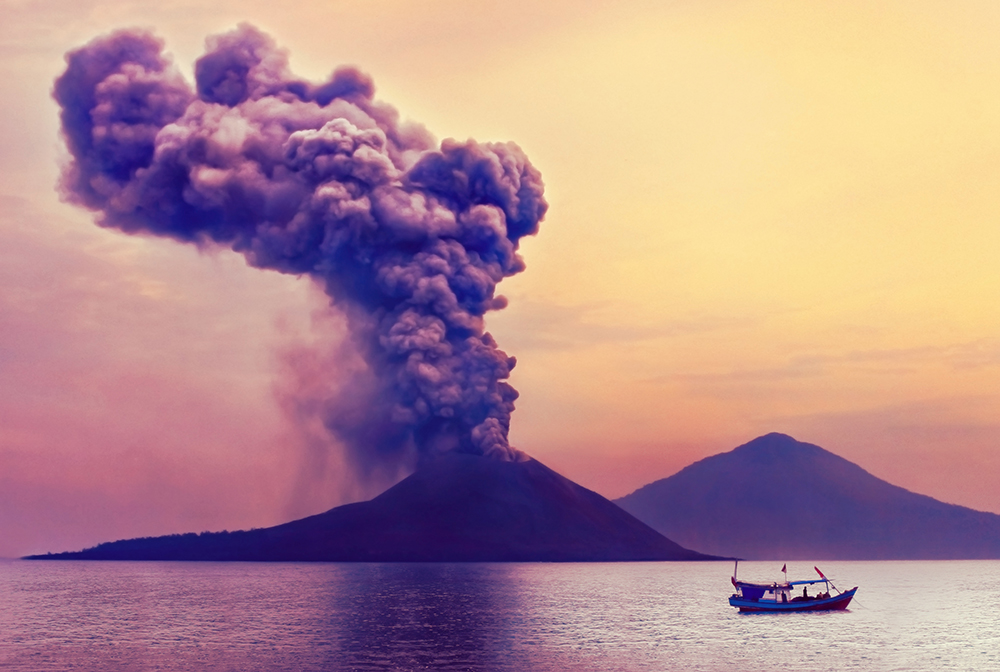
Of course it's obvious that when plates collide is when big quakes and major movements are most likely - the kind that displace huge amounts of ocean and generate tsunamis. The Australian plate is moving north at almost six centimetres per year, a similar rate to the growth of your fingernails. However, the Asian plate and some of the other microplanes to our north are not moving out of the way - it's a tectonic collision! This collision has created the massive Sunda Megathrust, a fault complex responsible for the big 2004 Boxing Day Tsunami.
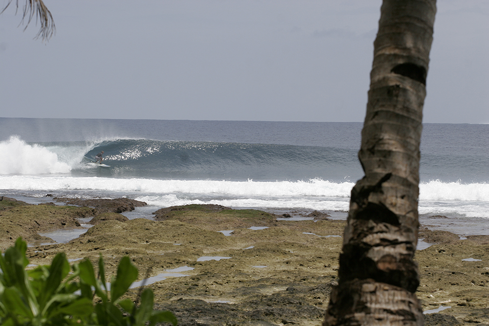
Thunders in the Mentawais showing once-submerged reef thrust upwards from a recent earthquake. Photo Craig Brokensha
Ocean crust is relatively dense and tends to be pushed down under the overriding plate, the old basalt crust slides down in to the Earths mantle to be recycled. As the ocean crust goes down, it takes a bit of sediment and water with it, and this acts a flux in the mantle, generating magma which then heads toward the surface creating awesome volcanoes. These volcanoes can grow pretty large, creating arcs of volcanic islands such as Bali and Lombok. Than can also create massive explosive eruptions like Krakatoa. The biggest eruptions leave just a huge, deep crater lake such as Lake Toba in Sumatra or Lake Taupo in NZ.
However, what gets interesting is that not everything on the surface of the ocean crust gets pushed under into the mantle. Oceanic Islands, even micro-continents and huge thicknesses of sediment get scraped off the down going plate and wedged on to the overriding plate. This is how Island arcs grow and evolve. Sumatra is a classic example, an island made of scraped off oceanic islands and sediments.
So what has this got to do with surf in the Mentawais? Probably a lot because all the islands from Simeulue all the way south east to Enggano are created by this process. If Sumatra is the bulldozer blade, the outer islands is the pile of dirt pushed ahead of it. If you have ever watched a dozer you would recognise that some times dirt is pushed up, and sometimes it tumbles or slides down, ahead of the pile. Interestingly, the reason why there is significant outer arc off Sumatra, but not Java and further east is that there is a heap of sediment in the Northern Part of the archipelago. Massive sediment loads are dumped at the head of the Bay of Bengal by the Ganges Delta, huge underwater landslides carry this sediment great distances across the ocean floor and a lot of it slides along the Andaman and Sunda trench, dumping it near Sumatra. The sediment does not reach further south and east, so we don't see fore arc islands off Java or the Eastern islands of the Indonesian Archipelago.
Simeulue, Banyaks, Nias, and the Mentawais are all the top of the pile as great wedges of sedimentary rocks have been scraped off the down going Indo-Australian Plate. Sometimes the wedges are pushed up, sometimes they are dragged down. Often there is sideways movement and the major Mentawai Fault leads to a swarm of North-South trending faults that move to accommodate some of the transform movement in this region. As the Australian plate is moving north-northwest it is actually sliding under Sumatra at an oblique angle. To accommodate the stresses, there is a long series of north/south trending transform faults in the down going Australian Plate. With the earthquake last week a couple of hundred kilometres south of the Sunda Trench, it was probably one of these north/south faults that ruptured rather than the main subduction zone.
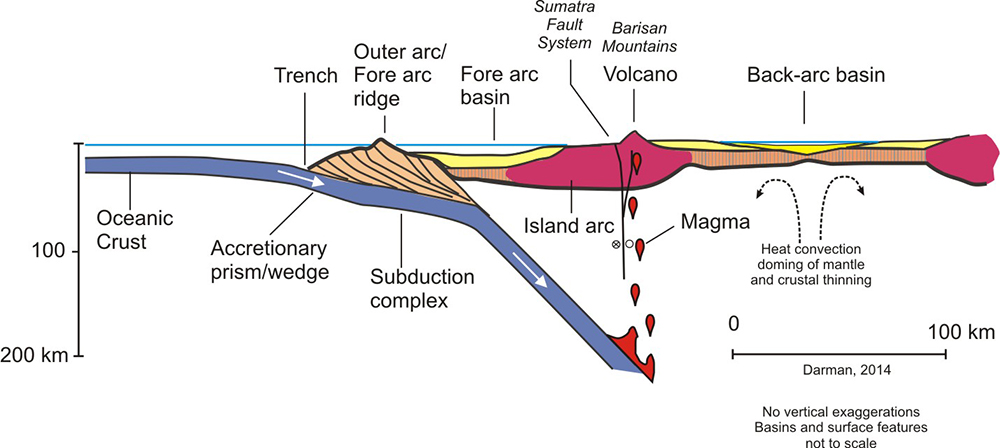
A schematic cross section of Sumatra showing the subduction complex in the region. Image courtesy Herman Darman
To a casual observer, all the earthquake action seems to be about the Sunda Megathrust itself. However there is so many more faults accommodate the differential movement of the plates and the slices of rock as they get shoved around. So the islands are actually made up of a bunch of blocks constantly jostling, being thrust up, or dropping down such that the coast is rarely at the same relative height for very long (in geological time). My theory (as yet untested by research) is that the coast of the fore arc islands is so dynamic, the coral reef do not grow in equilibrium with a sea level for long. Some reefs may be sinking (relatively) as the crust is down warped by the subsiding plate. In other places reefs are thrust up as blocks are pushed up along faults or as the crust rebounds. The reefs may have grown in well shaped ramps and lozenges just as a function of normal coral growth (see Coastal Creationism Part 8), however I suspect the constant change may augment the process leading to a high density of good waves.
There is lot that we don't know about about the processes of reef growth and adaptation to change in relative sea level. I think that the surfers are sitting on an incredible body of knowledge through observation. For this reason I want to throw open the discussion and ask you to contribute your own observations and thoughts.
This article builds on an excellent article by Craig Brokensha here on Swellnet and it should be read in conjunction. Also, blindboy has written a great article looking at seismic risk in the region.
Coastal Creationism is an ongoing series written by Chris Buykx. Chris is a geologist, traveller and lifelong surfer. Specialising in eco-tourism, his passion is interpreting nature and the environment. Chris is a resident of Sydney’s Northern Beaches.
Click here to visit every instalment in the Coastal Creationism series.
Comments
Hey Chris great stuff, didn't know that about Sumatra and fore arc islands, kinda thought accretionary wedges just wedged against continental margins and formed part of the mainland. The text and schematic cross section are a little unclear though... Is Sumatra a combination of this scrapped up sediment AND volcanic deposits? If so, what do you call it because it has fore arc and volcanic island arc characteristics
Good read, ive read lots about Sumatra but i dont think ive ever read this info.
Most Island Arcs are quite complex and have long and varied histories. It is rare for arcs to remain exclusively volcanic. The thing about accretionary margins is they grow outwards with whatever gets scraped on. Most often it is marine sediments, ranging from turbidites (marine landslide deposits), through to entire coral reef systems. You often find marine volcanics such as pillow basalts. Sometimes entire island arcs are scraped on to another island arc. This is how large arc islands such as Sumatra, The Phillipines and Japan have all evolved and grown. Eventually the back arc basin may close and the whole arc complex gets added to a continent. Sometimes a suture zone is marked by a bit of oceanic mantle in the form of serpentinite and other interesting minerals (Ophiolite complex). This is what happened to Eastern Australia north of the Hunter from the Devonian through to the Earliest Permian. The New England fold belt is best described as a tectonic melange. Each part of the accreted bits is called a terrane. This is how continents grow.
USGS are calling the recent earthquake as from a transform fault rather than the main subduction zone, which may be a worry as it is unlikely to have relieved stress on the zone of concern.http://earthquake.usgs.gov/earthquakes/eventpage/us10004u1y#general_region
Another great piece from a series, which I have well been interested in, thanks Chris.
In this piece you have mentioned NZ a few times, I gather that because it is situated between the plates, IE the major fault line. Is NZ a very young island in terms of age compared with others around the world?
I remember Mt Cook's top slid down the East face whilst living in Wanaka. At that time I knew climber who was staying at the Grand Plateau hut, ready to climb Cook at 2am in the morning. Lucky his and his alarm clock ran out of batteries, as they slept in, only to wake and witness the tonnes of rocks slide right through the route they would of been on?
http://www.livescience.com/42610-new-zealand-aoraki-mount-cook-shrinks.html
We flew into Tasman awhile after on a snowboarding mission and honest the amount of rock was amazing, it had gone up at least 300m, on the other side of the valley. Climbing in NZ is so full on, rocks are always falling on every route. You have to be so aware 110% of the time, but the wierd thing is it only takes a rock half the size of a soccer ball a few meters up to take you out, let alone tonnes of it.
Here is Plateau Hut in relationship, I must admit the old timers really thought of a great spot away from harms way;)
This was tiny one of Dixon, not the one of Cook in 1991?
Thanks Chris;)
Thanks Welly. Know the Mt Cook slide well as I spent a summer climbing there in 1993. Over the months i summited many of the peaks surrounding the Tasman Glacier, but stayed away from Cook because it was too sketchy. There is a reason they say the NZ Alps are made out of weet-bix! The Tasman Glacier was buried under hundreds of metres of debris. The treks out were epic moraine slogs through a chaotic wasteland.
As a newly graduated geologist and keen climber, I was pretty stunned at seeing the earth do things in real time. When you study geology in Australia you get used to seeing deposits and geological events that happened hundreds of millions of years ago. Heading to NZ, Indo and Japan I suddenly started to see the earth doing its thing, now!
So the question is- who has surfed in the Mentawais, Telos, Banyaks, Nias?
I want to hear about your observations - did you see evidence of reefs being raised, or lowered? Or both? What do you reckon was going on with the coral growth in response to changes in relative sea level?
I did a trip around Nias, Asu and Simeulue in early 2007 so not long after the event. the uplift in that region was quite stunning, the lagoon corals in front of the beach at nias and out towards indicators was just wasteland of dead corals for hundreds of metres. I took a stack of photos out on the dry reef if you are interested in them. Asu had lifted up as well and around Sirombu there were/are jetty's that just looked comically high out of the water. Simeulue on the southweatern side had raises out of the water whilst the other side of the island had sunk into the water, you can see this when you fly into Sinabang the tip of the island has lots trees that have died from being pulled down into the water. I guess in term of coral growth it was too early to see anything meaningful.
I have been back to Simeulue a couple of times since then in 09 and 11 and didn't notice any coral growth out of the ordinary around the breaks, probably due to the wave energy restricting coral growth. snorkelling around the lee side of island I didn't notice anything too spectacular either. my thoughts are that because the uplift was so dramatic any of the intertidal coral that would give you a good measure of sea level rise/fall such as micro atolls have been left high and dry with no new growth occurring yet. not sure on growth rates of that sort of coral but I would assume it would be very slow? Also if the coral was uplifted in a single instance would the coral polyps die with no chance of relocation to restart the process? will you see these corals return?
Having done a dozen trips to nias since 91 the changes to the reef and surrounding lagoon after the earthquake were profound , with massive deaths of most corals and marine life on the shallowest sections of reef and inside the lagoon system , Pre quake however the main section you surfed over wich was once pretty dead, now appears to have lot of new coral growth especially in the last few years since the reef has risen up so much , Now when you get out on low tide on the inside , you have to be a little more careful were you stand as new small coral heads are starting to appear on the reef , not so good if you dont wear booties or your on blood thinners like i am ...
Why are there so many good reefs in the Ments? My hypothesis is based on observation and talking to people up there about the timelines for the emergence & submergence of the reefs and islands.
Relative to sea-level, the reefs/islands are in a constant state of slow submergence or "sinking", pinched downwards in the plate shifting process. Then an earthquake sends a jolt through the place, and the same islands/reef spring up. For example Asu Island was raised at least 2m higher after the quake of March 2005. It was a sudden lift, overnight.
To put this into context, the reef slopes experience a constant wave erosion as they slowly sink. Slow steady attrition of the reef slope, which is always greatest in the intertidal zone (the zone between low tide and high tide). But because the intertidal zone is constantly retreating, moving inland, a smooth reef slope is sculpted.
Then again, maybe the place is just blessed by Lord Huey.
Sounds very plausible to me, if not damn likely!
Lets get a grant and spend the next few years doing field research.
Gotta be at least a couple of PhD's and several journal articles in it.
You know we often think the Mentawai's do have an abundance of good waves which they do, but the reality is the physical areas of coastline where there is lots of good waves is not the large.
For Example.
Siberut= Of it's 160Km of exposed coast its only the south tip that has good waves and the small islands of that area and about 130km is mostly close out beachies, maybe the odd river mouth or a reef.
Sipora=about 70km of exposed coast but again it's only the tips that get good waves Scarecrows to Icelands in the North, then Bintangs around to HT,s in the south, but that whole middle section about 40km although it has many bays doesn't have anything world class and pretty much a drive by bit of coast.
Nth Pagai=Over 50km of exposed coast but only Macaronis and Green bush are world class and there is less than half a dozen other spots, many of which are very B-grade or kinda waves, there is actually huge areas of just reef ledges just full on closeouts onto dry reefs, even cliffs, i know because ive walked much of it:P
Sth Pagai= is a bit better but again most of the waves are concentrated in one area which are Islands of rags and thunders, going south there i few spots but it,s not until you get to the hole that it's true world class again.
If you look at place's like Bali the concentration of quality waves is just as high if not higher, look at the Bukit it's quailty wave after wave of lefts, the on the other side right after right, then all kind of other waves beachies, lava rock reefs etc
I think if Bali was a remote Island only being exposed to the world in the last 20-30 years, we would be just as blown away by how many waves it has and the quality.
Sounds good Chris. Great read once again. Sumatra has it all. Spent a lot of time in Indo. Mainly focusing East of Bali ,Lombok. Huge pinnacles stand upward in ocean, similar to Victoria/S.A, W.A. Lombok straight is intense and deep. Does this help or hinder swell Chris ? Nias and outer islands have definitely changed. Risen over 2 mtrs.
Quite a bit of new land is now showing off the west coast of Japan following the earthquake earlier this week.
Wow, this is compression on the back of the Island Arc - suggesting potential convergence, activating old faults and uplift - whereas in past back Arc was extension and subsiding blocks and opening of sea.
Some recent numbers on the movement around Ishakawa
The Geospatial Information Authority of Japan said parts of the country moved up to 1.3 m (4 ft 3 in) westwards with the maximum displacement observed at Wajima due to crustal deformation. At Anamizu, land shifted 1 m (3 ft 3 in) westwards. However, the agency said these movements could be slope or local ground movement instead. The agency also added that crustal uplift of 4 m (13 ft) occurred in western Wajima and 1.1 m (3 ft 7 in) in northern Suzu. Near Wajima's port, shoreline of a sandy beach was moved 250 m (820 ft) seawards due to the coastal uplift.