Make the most of tomorrow

Western Australian Surf Forecast by Craig Brokensha (issued Wednesday September 6th)
Best Days: Tomorrow, Friday morning early on the South West magnets, Sunday and Monday mornings Perth and Mandurah
Features of the Forecast (tl;dr)
- Easing mid-period SW swell tomorrow with mod-fresh E/NE tending N/NE winds
- Smaller Fri with a little reinforcing SW swell. Strengthening E/NE tending N/NE winds
- W/NW-NW winds Sat
- Moderate sized + W/SW groundswell building late Sat, easing Sun
- Moderate W/NW tending fresher NW winds Sun (E/NE early to the north)
- Similar winds Mon with an easing swell
- Large mix of W/SW groundswells building Wed with strong NW winds
- XL surf next Thu and Fri with strong NW-W/NW winds, tending W/SW Fri
Recap
A continuation of large, choppy surf in the South West yesterday, moderate sized and poor to the north. Today is similar but with a small, easing swell in the South West though winds are due to go more south late in the day, so keep an eye on protected spots.
This week and weekend (Sep 7 - 15)
Winds are finally expected to shift offshore tomorrow morning but with a weaker, easing mid-period SW swell. Still, with moderate to fresh E/NE tending N/NE winds there should be fun options as the South West eases back from 5-6ft across the magnets, 2ft+ in Mandurah and 2ft across Perth on the sets.
Friday looks a bit smaller though a reinforcing mid-period SW swell should maintain 3-4ft sets across Margs, 1-1.5ft in Perth and Mandurah. Similar E/NE tending N/NE winds are due on Friday but strengthening through the day.
Saturday looks to be a lay day with a low point in swell as winds swing W/NW-NW. Later in the day a fresh pulse of W/SW groundswell is due, generated by a tight but intense mid-latitude low forming west of us tomorrow.
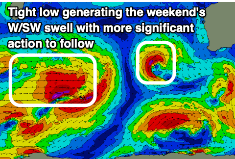
A fetch of strong to gale-force W/SW winds should produce a moderate + sized pulse of W/SW groundswell that should kick to 6ft+ on dark Saturday in the South West, peaking overnight and easing steadily from a similar 6ft+ Sunday morning. Perth and Mandurah should see the swell peak Sunday morning with 3ft sets across the latter and 2-3ft across the former.
Winds will remain onshore for the South West but only moderate, strengthening from the NW through the day. Perth and Mandurah should see more variable E/NE winds through the morning.
Similar winds are due Monday but with easing surf.

We then look to the large, onshore swell episode due through the remained of the week.
We're looking at a strong, slow moving gyre of frontal activity with multiple fronts due to fire up through the central to south-eastern Indian Ocean on the weekend, moving up and over to us through next week.
Each system looks like it may be a little stronger than the previous, resulting in XL swell trains arriving and building from the W/SW mid-late next week and being quite sustained.
This could be the most significant frontal outbreak of the year with XL swell lasting over days but with strong onshore winds, initially NW-W/NW, then shifting W/SW late next week. We'll have a closer look at this on Friday.