Indonesia/Maldives forecast May 16
Indian Ocean Basin analysis by Craig Brokensha (issued Thursday 16th May)
This week through next (May 17 - 24)
Yesterday’s swell is slowly easing across the region, but our inconsistent groundswell for tomorrow and Saturday is on track, with it performing well in Margaret River.
There’s no change to the expected size, with it due to peak tomorrow afternoon/evening, easing slowly into Saturday and further Sunday.
It’ll be well worth making the most of as the outlook from here on in is very slow until the end of the month.
The Indian Ocean will fall very quiet storm wise with small background levels of swell due to arrive through next week from fluky sources.
One of these is a small mid-latitude low that’s currently north-east of the Heard Island region, with a very short-lived fetch of tight, gales due to produce a spike in swell for Monday afternoon and Tuesday morning, easing thereafter.

There’s then nothing significant due until the end of the month, but we’ll have a closer look at this next Tuesday.
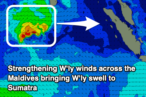
It's worth noting in the Mentawai and north Sumatran region, a funky W'ly swell is due from a deepening low south-east of the Maldives, producing a strong, persistent fetch of W'ly winds. Size wise we may see surf hitting 4-5ft+, but check back Tuesday
--------------------------------
Over to the Maldives and a fun pulse of S’ly groundswell was due to fill in today, ahead of a better pulse later tomorrow and into Saturday morning.
We’ve still got strengthening W-W/SW winds on the cards for the coming period, feeding into a deepening low south-east of the region, and these will create tricky, blustery conditions while also adding W’ly windswell to the mix.
On the southern side, strengthening SE winds should generate some moderate sized S/SE trade-swell through the weekend and early-mid next week, peaking in the 4ft range across the southern atolls, a little smaller in Male but not much.
Otherwise we’ve still got additional S’ly groundswell pulses due mid-late next week thanks to back to back storms firing up under South Africa.
The best is due Wednesday afternoon and Thursday morning, with it being moderate in size, generated by a low passing under South Africa this evening and tomorrow.
Following this a moderate sized mix of background S’ly swell and SE trade-swell look to persist in the 3ft+ range. We’ll have a clearer idea on Tuesday though.
Eastern Indonesia:
Moderate sized, inconsistent S/SW groundswell building tomorrow afternoon to 4-6ft across exposed breaks, easing Saturday from a similar size.
Small-moderate sized background swell for later Monday, peaking Tuesday to 4ft, easing into the end of the week.
Moderate to fresh E/SE trades (stronger over the weekend and Monday), variable offshore each morning.
Uluwatu 16-day Forecast Graph/WAMs
Western Indonesia/Mentawais/South Sumatra:
Moderate sized, inconsistent S/SW groundswell for tomorrow, building to 4-5ft+, easing Saturday.
Small-moderate sized background swell for Monday in the 4ft range.
Building mid-period W'ly swell across northern locations to 4-5ft later next week.
Variable winds, tending S/SE from Tuesday across southern locations, possibly stronger late week.
Mentawai 16-day Forecast Graph/WAMs
Maldives:
Inconsistent S’ly groundswell today to 3-4ft on the southern atolls.
Stronger S’ly groundswell for later tomorrow, peaking Saturday to the 4ft+ range on the southern atolls.
Moderate sized S/SE trade-swell for Sunday afternoon and early-mid next week to 4ft+ across the southern atolls, smaller to the north.
Moderate + S’ly groundswell building Wednesday afternoon to 4-5ft across the southern atolls, smaller to the north, easing Thursday from a similar size.
Weak W’ly windswell in the mix across selected locations from the weekend, through next week.
Strengthening W/SW winds over the coming days, really strong from Saturday afternoon through next week, easing next weekend.


Comments
The latest notes are live.
Thanks Craig, geez It’s going to be on at the end of the month if that forecast holds , fingers crossed. Fun pulse yesterday morning and arvo then really inconsistent today. Tomorrow looks promising then it might be time for some fishing but locals aren’t getting much and reckon waters too cold .