Coastal Creationism - Part 9: Creating perfect sand-bottom points that peel forever
 Why are sand-bottom point breaks only found in northern NSW and south-east Queensland?
We all know that on the East Coast from Crescent Head to the Sunshine Coast is point break heaven, but what is it about this coastline that creates epic points? Why, for instance, are there no sand-bottom point breaks south of the Hunter River? The wave climate is not that different but the coastal landforms certainly are.
The simple answer is summed up in this equation: Sediment Supply + Wave Climate = Sand-bottom Points.
If you compare the coast south of the Hunter River with northern NSW and south-east QLD, there are significant differences in the coastal landforms. To the south there are steep valleys, deep harbours, and multiple lagoons and coastal lakes. All are a function of the same process. The coast of Sydney and the south coast is what is called a 'Flooded Ria' of estuaries filling steep sided valleys, almost like a fjord.
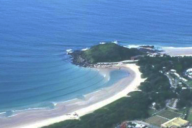
In these locations most sediment coming down the rivers goes toward infilling the valleys that create the lakes and estuaries. Fresh sediment does not make it as far as the ocean. However, northern NSW and south-east QLD is dominated by large rivers with extensive floodplains. The deep valleys in the bedrock are separated from the ocean by extensive coastal plains, therefore these rivers deliver most of their sediment load directly into the ocean. This sand is then transported by longshore drift to accumulate in perfect triangular banks in the lee of rocky headlands.
The flooded coastline of the Central Coast and further south - think Hawkesbury and the coastal lagoons - was created when sea level rose 120 metres at the end of the last ice age. The region is also interesting as the bedrock has been uplifted, creating the plateaus and escarpments that dominate the coast. The uplift created a gradient close to the coast. Due to the low sea level during the ice ages, the rivers carved deep V-shaped valleys to the very low base level, possibly as deep as 180 metres below the current sea level. At this time the coastal plains were exposed with extensive deposits of sand heaped in dunes.
With sea level rising from about 18,000 years ago, some of this sand was pushed inward and upward, forming coastal barriers with beaches and dune systems. When sea level reached its current level, stabilising about 6,500 years ago, all the valleys were flooded forming the harbours. Where coastal sand barriers had been pushed in, they closed off valley mouths to form the coastal lakes and lagoons. Ever since, most of the sediment loads of these rivers has been filling in the estuaries and does not reach the sea. For this reason most of the reefs and points of Sydney and the South Coast are actually formed as a function of bedrock geology rather than sediment accumulation.
Conversely, from the Hunter and Manning Rivers north to about Agnes Waters, large rivers with considerable sediment loads have already infilled their valleys and are now delivering bedload sediments directly into the surf zone. These sediments are probably augmented by a large supply of readily transported sand that may have already been in place prior to sea level rise, ensuring that there is a mass of sand available for longshore transport.
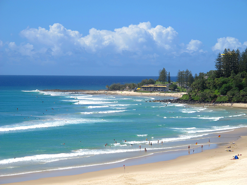
The dominant wave climate of the east coast is of higher energy swells coming from the south through to the east. Cyclones bring occasional energy from the north-east, however these are rare yet enjoyable interruptions to the regular wave climate. The southerly origins of most swells ensure that sand in the active wave zone is inexorably transported northwards through a process of longshore drift. Whenever this sand rounds a rocky headland it is deposited in the lee, forming a nice triangular bank that can turn swell in to peeling, spitting, gurgling barrels for us to get kegged. Depending on the slope of the sandbank, these may range in shape from thin lipped peelers (shallow slope) through to thick sand filled drainers (steeper convex slope).
The best example of this process is the artificially augmented Superbank. The natural process of northward sediment transport had been interrupted by the breakwalls channeling the Tweed River. When the process was restarted with sand pumping, the Superbank was formed in the lee of Snapper Rocks. I am not sure what sort of bank existed at Snapper Rock prior to the Tweed breakwalls but as soon as the sand supply was stopped, big holes formed in the bank. Nowadays they think they understand the process enough so as to manage the sand supply and the subsequent shape of the bank.
You only need to look north to see where it all ends up. At the northern end of the Gold Coast the great sand islands start: South and North Stradbroke, Bribie, Moreton and Fraser Islands, which are the eventual repose of millennia of sand transport. Keep in mind this sand has accumulated over perhaps a couple of million years, with about 17 ice ages and warmer interglacials all doing their part. The ice ages and low sea levels allow the sand to be spread out on the coastal plains and then as sea level rises, the sand is pushed in to the surf zone, creating beaches and dunes, as well as moving the sand north due to longshore drift.
As mentioned in Coastal Creationism 5, the West Australian coast is different, there is just not the same amount of mobile sand. Yes, there is plenty of sand on the beaches, however with the generally drier climate and lack of large rivers delivering sediment to the sea, a greater proportion of the sand has been formed by biological sources - the shells of millions of organisms. In the west the sand is dominated by shelly carbonate fragments. However, in eastern Australia with its higher rainfall and steeper gradients, there is significant land based erosion, transport, and deposition of sediments on the coast. As a result, eastern Australian sands are dominated by terrestrial grains, chiefly quartz, plus some of those heavy minerals like rutile and illmenite. So in the west, the sand has lots of carbonate and readily becomes cemented and locked up in limestones. In the east, the sand remains mobile, accumulates over millions of years and eventually to be swept in to the lee of a headland and form a triangle of fun!
Coastal Creationsim is an ongoing series written by Chris Buykx. Chris is a geologist, traveller and lifelong surfer. Specialising in eco-tourism, his passion is interpreting nature and the environment. Chris is a resident of Sydney’s Northern Beaches. Read past articles:
Part 1: Basic reef shapes
Part 2: Complex curves
Part 3: The good, the bad, and the ugly of coasts
Part 4: Sedimentary sequences and superior shapes
Part 5: Sand dunes and limestone
Part 6: Slabs!
Part 7: Coral reefs are even better than you think!
Part 8: Coral reefs, living and adaptable surf zones
Comments
awesome
that heavier, finer grained sand found here also packs in a lot tighter, and forms more stable inshore formations/slugs.
\
Can feel like concrete if you hit it hard when it's shallow.
Since I've been on the Tweed Coast (last seven months) I'm amazed at how much the points' sand banks can change over time scales of a couple of days to a week.
Sometimes, from so little sand that waves under 3ft won't even cap, let alone break - to epic, hollow barrels, all within the space of a week. Just phenomenal.
And then there's the general beachies too. They seem to change almost daily 'round here.
Thanks Ben, this opens up a whole new line of discussion. By this i mean the interplay between swell direction, wavelength, period and a given slope of a bank. Did you happen to keep a swell diary? With a scientific mind you could be in a position to start plotting the variable and deriving some insights in to these relationships.
For example a 3 foot wave of 14 second period will 'wrap' on the point. When this occurs the orthogonal of the breaking wave will curve inwards as the wave move along the ramp. Imagining this in 3D and the profile the breaking wave follows is no longer a flat ramp but a convex profile - hence thick lipped and grinding barrels on a bank that appears to be a smooth, flat ramp at a nice peel angle.
Now a 3 foot wave of 9 seconds from the same direction will not wrap. it will roll along the ramp at a nice peel angle, however it can be kind of mushy.
You're not wrong, particularly the points in the Tweed. Can change from boulder strewn semi point to groomed sand bank in a week sometimes…….unfortunately the opposite is true. There are a couple of spots (beachies) around here that have had very consistent banks for around 12-18 months now, not sure why this is so, there doesn't appear to be any rock near by
The one thing I have been waiting for you to discuss regarding barreling Coral reefs are the fingers that drain water from the reef mainly at mid to low tides.
I dived on Bingin a couple years ago (when it was flat) and those channels that feed the water back against that famous wave are each like a rip channel - they were not small either - possibly 2mt plus wide and 2mt deep in the impact zone with the coral surface that is curved towards the depths about 1.5mt deep.
This is similar to Ulus and GLand etc
The only reef that defies this is Periscopes in Sumbawa. I didnt recognize the reef walking past at low tide as was a billiard table flat reef with a 2 to 3mt drop off facing south west wave direction - went back next morning at High Tide and was utterly amazing but was sectioning at the small size I got it but at 2mt plus would have worked ok - reason why is because it didnt have the fingers for draining to enlarge the barrel and wasnt greatly curved facing the swell -
Also good beach breaks always seem to be better with a rip channel to lift the face and give you a free ride out - eg Phillip Island -
Thats why I believe - and this is my untested opinion - that until you create those fingers in an artificial reef you wont get real power from the wave - Cheers.
Hasn't been an article on it, but we did discuss this at some depth in one of these articles comment section, maybe try digging up the coral reef one (use goggle better than the swell net search function), forgot what those channel/fingers are called but they even have a name.
Spur and groove formations Indo.
Thats it, got to remember that.
I think sand points are my favourite type of wave its like the best of both worlds like a reef but changes like a beachie.
Where else in the world are there groupings of sand-bottom points? Mexico has some, South America, various locations in Africa (both South-East and North-West/West).
I would guess the additional sand to power those point breaks is due to the desert surrounds rather than rainfall and river plains? Are there other places (without exposing secrets) that I'm unaware of?
Hobart points are a great collection of fickle points and although they look like reefs i believe the bottom of most is sand (packed over reef/boulders)
Namibia and the western African coast?
Think Skeleton Bay.
Similar source (longshore drift of sand).
Chris, sir, I'd love to be sitting next to you in the lineup, soaking up some of your wealth of knowledge whilst waiting for a set.
Sure, if I get first crack at the set when it arrives!
This is a great informative series that i find really interesting. Im trying to apply whatever knowledge i get out of this to get a greater understanding of where i live. Still i can only take a guess that a coast that faces perpendicular to its swell source is not the greatest. Im actually not sure if there is many of places like the Mornington Peninsula in Vic where the various sandy beaches as stated before face perpendicular to swells, perhaps we get a 20-25 dergee variance. We get anywhere from 1ft-12ft swells yet little seems to change regardless so i can only put it down to the swell direction/coast facing combo.
Ild be happy to hear anyones two cents in regards to this.
P.s i hope it makes sense. Thoughts in my head struggle to get out properly..
This has also been discussed here before in a bit of depth including about the morning ton peninsula beachies, not sure where it was disgust though maybe under one of these series or in the forum area somewhere.
Our beachies over on the island are the same, i don't think its a bad thing though it helps create rip banks that go straight back out, while many long beaches that receive most of there swells from more of an angle get gutters that run long shore to the beach often creating straight close outs unless the swells are peaky. (very short period swells)
The northern end of the gold coast is an example of this same as are areas of the Sunny coast and possibly the best example of how bad banks can be on beaches like this is Fraser Island where for 100Km or whatever it is there is barely ever a bank, just a close out shore break then a deep gutter for 50 to 100 m then a close out bank that is only about 10 metres wide.
" therefore these rivers deliver most of their sediment load directly into the ocean. This sand is then transported by longshore drift to accumulate in perfect triangular banks in the lee of rocky headlands."
Great series Chris, have really enjoyed it. Sorry to be pedantic, but the above statement just isn't correct. The sand on the beaches and points is composed of Marine Sand, not Fluvial (ie. River) Sand. Even on these large floodplains, during large floods, there is very little (if any) delivery of contemporary fluvial sand to the ocean. Only the finer grain suspended material (silts an clays) makes it to the ocean.....hence the large plumes of brown water during floods.
The rates of erosion of the catchments east of the Great Dividing Range are so low that contemporary delivery of sand sized material to the coastal sediment budget just doesn't occur. This is evidenced by the incursion of marine sand in the form of flood tide deltas into these river systems for several km in many cases and likewise, the absence of any fluvial deltas protruding into the ocean......(there's plenty of peer reviewed journal articles on this stuff).
All the sand on the east coast beaches/points is a relic of re-workings of material deposited during the Pleistocence and earlier, over multiple glacio-eustatic SL rises and in particular the last one, defining it as Holocene beach sand. The re-working (being pushed up and down the shelf in the surf zone over eons) has rounded the sand grains off and cleaned out the silts and clays.....giving it that 'golden look'.
Thanks for series, has been great.
Thanks Justin. Appreciate the contribution. Keep in mind this article is written for the casual reader is I have not attempted to lay out a timeline or get in to the specifics. Its just the very, very broad differences between the SE Qld/NSW North Coast and the NSW Central and Southern coast.
I am aware of the 'marine' nature of most coastal sand bodies - See quote below from second last paragraph. However if you consider a long enough time line (and this article does), most east coast sediments are derived from the erosion of the land, as opposed to marine origins such as shells and corals.
"Keep in mind this sand has accumulated over perhaps a couple of million years, with about 17 ice ages and warmer interglacials all doing their part. The ice ages and low sea levels allow the sand to be spread out on the coastal plains and then as sea level rises, the sand is pushed in to the surf zone, creating beaches and dunes, as well as moving the sand north due to longshore drift."
Great series Chris, thanks a lot.
From my understanding, a lot of marine sand is moved by seasonal events, e.g. floods and heavy rainfalls. These events move built-up sand near rivermouths and increase the longshore currents. An extreme example is the El Nino in Peru: heavy rain floods the coastal desert (one of the driest in the world) and gets the coastal/marine sand moving. A few months later the longshore current delivers the sand to the points. Is there a comparable effect in NSW/Queensland?
You have pointed out a very important aspect of erosion and deposition. That is 99.99% of the work is done in 00.01% of the time. Geology is a record of extreme events. Giant floods, landslides, earthquakes, tsunamis, storm swells, cyclonic winds. These do all the heavy lifting when it comes to major erosion, transport and deposition.
The everyday creates what we usually see, such as sandbanks and longshore drift, flood and ebb tide deltas. But in geological time these deposits are more likely eroded by an extreme event that then leaves a major deposit. So the geological record rarely records the everyday processes.
Wow, never thought about it like that. Penny, drop.
When do we get an article on Perth closeouts? Like Eskimos and snow, Perth surfers actually have 15 different words for closeout. True fact.
http://www.swellnet.com/news/coastal-creationism/2015/11/16/coastal-crea...
This article covers why so little swell energy reaches the Perth Beaches. There are more factors that result in the closeouts, but the lack of wave energy is very significant. Some time in the future it would be worth coming back to this issue, i will add it to the list of topics that need exploring.
Thanks - my comment may have been made with my tongue in my cheek. I'm sure there is a lot of science behind the continual disappointment of Perth. I guess that is what the car keys are for.
15 different words for closeout, that's funny stuff HBB...
It's actually a very difficult type of surfing to pursue. Everything happens so quickly, is often so barrelly, and over so soon. A good surfer in the metro area has cat like reflexes and often rides quite high in a very bowly face, traversing or pumping to get as much ride length as possible. Distance makes the heart fond they say, and I really look forward to going back to pit myself against the clock of the manic dumpers when I am seeing family and surfing this coast with mates. Usually the shutdowns win.
Why are sand-bottom point breaks only found in northern NSW and south-east Queensland?
I must be missing something here, while i think these points of this region are great waves, the two best point sand bottom waves i know of in Australia are not in this region....i understand is an opinion based comment but.....
From your personal opinion Chris, why have artificial reefs such as Narrowneck near Surfers Paradise never really worked? Is there any place that you are aware of that quality artificial reefs break frequently and with any amount of quality?
Surfing could be described as a financial and definitely cultural lifeblood of the GC. It's the only reason I would make the drive south that's for sure. With so little options and low percentages of great waves, and when the waves are on, it is soo crowded. Surely, there must be a few people proposing man-made artificial reefs for places like Southport, Surfers, Mermaid, Palm Beach and the huge waste-beach of Bilinga/Tugun?
This would spread the crowds, open up more consistent breaks, less travel required for locals etc etc etc. The only things I can think of that would kill the idea would be either: 1. Man-made reefs do not work. 2. Too expensive (although surely there would be a financial benefit in the long term.) 3. No-one has proposed anything since the failed Narrowneck.
Great article.
Man made reefs and breakwalls only seem to provide some good surf if its by accident.
b bear
The dreaded closeout beachie....
Copy and paste from my comments on a previous thread:
Poor sandbanks and beachbreaks are usually associated with (usually in combination):
1. a dominant swell direction parallel to the beach profile - often in recessed beaches deep in bays where only the one direction comes through. This removes the potential for angled directions to create tapers and the possibility of two directions at once to create peaks as they intersect. It also lessens any longshore drift effect - so no build up along headlands.
2. predominance of low energy swells and / or very settled swells - often again deeper into bays and following significant refraction (compare Waitpinga - heavy powerful open ocean beach in SA to Chiton Rocks around the corner in Victor Harbour - settled softer swells). This lessens the tendency for deep rip channels to form as they waves energy and water movement can easily dissipate. Only storm swells create deep channels.
3. fine heavily compacted quartzite sand such as on granite coasts which seems to resist channel formation more than looser sandstone and shell grit.
4. rare localised storm events to tear up the beaches with short wave period multi wave sets
5. headlands that are at greater than 90 degrees to the beach profile as these allow water build up in the vicinity of the headland to pass out to sea without creating the "next to headland" channel so important to many spots.
6. Overly stable beach profiles and dune systems due to the above factors and made worse by by marram grass or beach grooming
7 Limited tide movement - dramatic tides increase current flow (often banks can appear around the full moon due to increased tide activity
8. Lack of offshore bathymetry and water movements to break up incoming swells (can be a bombie, offshore sand banks from a river mouth (Dbah). Interestingly at Dbah you can watch the outer banks AND the outflow of current from the Tweed River cut up the swells before they move into the beach in peaks.
Lots of this around unfortunately. The biggest issue with poor banks is always on coasts where swells come from one direction only. Many of these are closeouts over a few feet in height, whereas exposed coasts with multiple direction swells coming in over time will always have their day due to angles swells and combined swells. Perth, protected WA coasts, some parts of Victoria and SA and SE Tassie suffer most from this.
Artificial reef solutions?
Artificial reefs could transform such straight beaches but would have to work with the sand dynamic not against them as has happened in ASR NZ attempt and deal with the eventual tendency for the reef to be slowly buried. They may need to use an existing rock outcrop or underlying bedrock as a base and in my view, create their own rip set up to drive sand movement favourably. If they channel the water movement outward in a set direction, they could create a permanent rip and sandbank and save spending millions of tonnes of rock or sand bags. A wave tank could model the ideal shape. Some exist in nature that could give us clues to how they can work without longshore drift.
There was a Volcom air comp here Perth 10 or more years ago where I don't know if it was the organisers or council (probably not the tight arse council) got a front end loader and pushed a couple of slugs/points of sand out into the water no more than 2-3m long. I remember sitting there thinking what the fark are they doing but the weekend after when the comp was on the waves were pumping. It created two really good A-frame banks either side of where they pushed the point out. The small sand point must have disrupted the S to N longshore flow, which we get a shiteload of due to the predominant SW wind, and directed it back out to sea when the flow hit it. I've never seen them do it since and would love to know how to get them to do it again and on a regular basis. Surely it couldn't cost that much to drive a front end loader up the beach creating little points every 100m or so.
I always though that Perth sand just went virtually straight out and straight in? Am I missing something?
I'm no expert but my understanding is that and moves S to N in the summer months with the prevailing SW wind that howls each day and then if we get NW winds from winter fronts this pushes it back S. Yes sand also moves in and out and as I mentioned below I reckon the abatement of this due to the revegetation of the dunal system has stopped a lot of this outward/inward movement. There just doesn't seem to be as much sand on the Perth coast anymore.
Chris I'd be interested in your view on this?
Why are sand-bottom point breaks only found in northern NSW and south-east Queensland?
I'm still confused that nobody has disputed the above quote -- particularly the guy from the Mornington Peninsula!
Quarras isn't a point break, it''s a rivermouth sandbar.
Havent surfed Lorne Pt since i was a kid but that has a lot of sand, Bastian point in East vic although now screwed up has a sand bottom, as do many points in Tassie.
Don't worry about this intro line too much, its a big picture analysis.
One thing I've often wondered having lived on both the Gold Coast and Sunny coast and surfed heaps around the NSW North Coast is why doesn't sand really build up much around Moffits and Pt cartwright?
Both have entrances nearby to supply sand and I would have expected the sand flow moving north along the coast would sit over or around the reefs but it doesn't really nothing like the Goldie Points or Noosa.
Why?
wow.....OK, Great article Chris, well researched.
I've often wondered the same thing indo. Figured with Moffs there must be some offshore rock formations directing sand away. The rocks at the little burger at Neil st get exposed and covered over the course of a year and the actual reef offshore must be affecting what sand gets in. Figured something like that affected Moffs. And carties is south of the river, sort of, so maybe it pushes away from the point.
But then just reading Justin's comment above. If there's little contemporary river sand making it out then it sounds like we're looking at a much older sand supply being pushed around by nearshore currents and little fresh replenishment. I dunno because the banks at the mythical SC bar that everyone fell in love with change every few days, as you know, so that sand must be going somewhere.
I suppose "flows" out of the passage are pretty weak hydraulically speaking, so probably why we just see a brown plume that seems to follow a vague channel all the time in that area. Until it spews out across the headland to the north. Gees I dunno.
Would have been interesting to see or know what that point cartwright area was like before the break walls?
Moffats i would have expected the sand that natural flows north would have settled around the point and in summer NE conditions it would be pushed back and packed in there.
But sadly its not the case.
Chris f your reading this any ideas?
Why does sand pack around pretty much every QLD point but these two miss out?
'Circa 1960. Looks like an unreal inside bank through to Mooloolaba beach. Looks to me that there wasn't much of a sand build up across the main break though.. maybe the sharp angle of the headland and the high elevation of the rock platform (relative to southern GC points), not allowing a deep sand layer to build up?

'Circa 1969

Great shots, yes certainly looks like a bank into Moolooly. Any old blokes you know who would have surfed Noosa in those days.
It seems in this case enabling safe boat access to the open ocean has a lot to answer for when talking about the degradation or destruction of a break. We had an example here in WA where in the process of creating an opening from the Mandurah Estuary to the ocean resulted in the best reef break in the area, I think it was called "Rubbish Tips", being callously blown up to create the passage. Not only that but it stopped the longshore flow of sand up and down the coast which meant Avalon point has been stripped of a lot of the sand that made the wave. It still does build up during summer but if you're not on it when the first few swells of winter come through the sand is quickly washed away and it becomes very sectiony and is frequented by mals and SUPs which makes it even more uninviting. I'm not sure we will ever truly understand or appreciate our affect on nature in these situations, much more study is required I believe.
I have not surfed either Moffats or Point Cartwright, so I am only guessing. Very happy if others have some insights to offer.
My guess is that both Moffats and Point Cartwright have extensive rocky reefs extending out to moderate depths (>-5m). Sand will occasionally fill in the holes in the reefs or build temporary ramps, however given the orientation and depth of the rocky reefs, the sand will occasionally be swept away.
Classic sand points tend to have a steep sided rocky point and the sand infills to great depth in the lee.
Snap! This pic sums up your thoughts (and mine) re: rock platform.
Good use of the Swellnet chopper Ben. Can i borrow it next time?
Okay..yeah they both have lots of reef ledges….thanks for replys guys..and the pics…..poor sunny coast crew they got so screwed over by nature and it looks like even human change (break walls) have screwed up things rather than improve like the Goldie.
Id take the moffats and carties area breaks over the gc points.
Quokka, how long did those man made sand bars last after the comp?
I have been reading a lot lately and there have been plenty of claims of people/companies inventing man-made inland breaks etc in dams or purpose built wave pools etc. Great ideas. Cost a ship load though to make and run surely. Little A-frames up and down the coast would be fantastic when the swell is straight. While pushing with a tipper some sand out would be a start, surely, there would be some permanent options avail too?
Any thoughts?
My view is that if you push out a sand bank with an excavator (quite easy at low tide) in a locatin where a natrual bank tends to form (most beaches have semi regular channel bank formations) you could get it to last quite a while as it works with the natural sandflow. But if you push one out where they never form they can wash away in a night. I once saw a small temporary sand groyne constructed to allow a storm water pipe to be layed down out beyond the surf zone. Once they took away the protective panels along the sides after the job was finished it was left exposed. I thought it might last a few weeks but overnight the swell kicked and no trace was left the next morning. If it is not meant to be the ocean will sweep it away very quickly.
Something as substantial as a mini groyne angled to make a natural catching point for water movement in its lee may be needed. Anything too low key will get buried or swept away in a storm . Another option would be a small groyne angled to create a rebound wave as this would not need a lot of rock or science. Wave surrges up the wall, hits an overhang and reflects sideways creating a minin Dbah set up. But "so not in my backyard" / environment concerns will stop these ideas unless it can be tied in with protecting homes from erosion. So with sea level rises we may get councils and communities more supportive of such dual purpose surf spot creation / erosion protection ideas.
Frog you are right, they didn't last long but good waves for two weeks is better than none all year. We have a few groynes on the Perth coast but they don't produce quality waves, the only one that might is Cott but even that never breaks now. These groynes used to provide some good waves but I put our now crappy waves down to the artificial stabilising of our due system which seems to have narrowed the beaches and stopped natural sand flow back into the ocean. 20 years ago we got decent waves during winter and spring but now they are always rubbish and with more surfers in the water than ever it is nearly impossible for me to get motivated to tackle the surf in Perth. We desperately need some attempt at man made waves here because nature is not succeeding at the minute.
GT probably a couple of weeks which is not a long time but our sand over here doesn't lend itself to long lasting banks anyway. Natural banks never last more than a month at best. I wold love some permanent options but on highly used beaches I fear these will always meet resistance, especially from councils where their liability is at stake. The funding and approval process also seems very problematic. there are sections of the Perth coast where not many people swim but still receive swell so these would be the best options. We get some great conditions during winter but time after time I stand on top of the dunes looking at 5k's of closeouts from Floreat to Trigg point.
Chris…you can see from above the interest in man made. As mentioned above, why not a simple solution as a front end loader to create V sections along a beach line. Likewise rock filling to improve bathymetry on the many possible coastal points. Is there an engineering to this - harbour contractions, break wall constructions which can be referenced ?
Very interesting article(s) … thanks.
Chris good article,but am wondering on what effect sand mining for heavy metals such as zircon etc has had on the points and beaches over the years.A good part of queensland and nsw was mined and if you've ever held a handful of black sand you know how heavy it is, so i would think that along with changing the sand dunes and removing the heavy sand it must change the formation of banks from what they used to be.
http://willkemp.net.au/enviroscience/land-degradation-and-rehabilitation...
I live on the mid nth coast where there are lots of headlands of various sizes and mostly boulder dominant, and also some complimented by scattered bommie/reef. From my observations over the years, the longshore drift of sand can quite often bypass these points, leaving no decent banks. However, throw in some energy from the north east and the rips start to fire better depositing more sand back into the southern corners. I actually think the build up of sand in these southern corners happens most during a week or two of strong November northeast wind blasts. This action seems to push the sand that might have otherwise bypassed the points back into the corners. This wind combined with some decent low tides also feeds the beach and dunes with more sand.
I'd like to hear your opinion on this Chris, cheers
Sounds very plausible Dingo. Most of the northward longshore drift occurs during the caller months dominated by S groundswells.
Accretion of sand to banks and the beach dune system mainly occurs during lower energy, short period swells from the E and N over the warmer months.
I agree dingo, your theory seems to be supported in reverse here in the west. The prevailing summer SW winds in Perth drive sand north to the only structure favourably aligned to catch it, Trigg Point. This is the only wave on the entire metro coast that is surfable during summer. During winter if we get the strong NW'ers the sand is moved back south to a degree but a lot seems to be lost, not sure where to. We have three other groynes (Cott, City Beach & Floreat) all of which produce a rideable wave if the stars align. Cott requires sand to come from the N due to the angle of the groyne (W/NW), City beach groyne faces W and is not long enough to create any decent bank and Floreat is just too short to create a bank.
I find Chris' comments interesting about the sand structure over here being more shell based which to me also explains why banks don't last as long, with the sand be lighter it gets moved around a lot more easily. In summary we need some sort of feature to either capture or at least disrupt the sand flow to create some banks because our coast currently must have the worst surf of any Oz city that receives swell. Bring on the front end loaders!
Hi, any further info with that new great tool from google?
https://earthengine.google.com/timelapse/
I would love to have your opinion on spot like DI or GC!
Thanks!