Coastal Creationism - Part 13: Island chains, hotspots, and lava
 Stretched across the ocean basins are long straight lines of volcanic islands: what's the difference between them and island arcs?
Now that we have opened the discussion about plate tectonics and the movement of oceanic plates, we can start to explore a huge range of features that dot the ocean basins. One of my favourite tools is Google Earth, because it reveals the shapes under the sea surface. Regular maps are great too because they show islands, but with the majority of the planet under water it's a massive boost to be able to gaze across long mountain ranges, towering seamounts, broad plateaus and deep trenches.
When you zoom out to an ocean wide scale, the eyes are drawn to all sorts lines and geometric features. Sometimes it's geometric and looks like massive Nazca lines etched into the ocean floor. Other times the deep trenches give a palpable sense of ocean crust being pushed down and subducted under the overriding plate. When you look at the spreading ridges, where new ocean crust is created, you often see long transform faults, perpendicular to the ridge. These faults are how ocean crust accommodates the curvature of the earth and different spreading rates as the opening zipper of the rift spreads across the sphere.
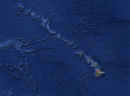
One of the most obvious features on a map of the Pacific is the Hawaiian Island chain. Looking at this on Google Earth reveals a long line of seamounts stretching from the Hawaiian Islands in a straight line to the west-northwest to Midway Atoll. Then, in the middle of the North Pacific, at a similar latitude to Tokyo, the line of seamounts takes an abrupt change in direction to the north-northeast, stretching unbroken to a deep notch in the trench between the Kamchatka Peninsula and Bering Island.
In our previous article we talked about volcanic island arcs and the incredible seismicity of colliding plate margins. But is the Hawaiian - Emperor chain of volcanoes an island arc? Why don't they get big earthquakes? And why does Kileaua Volcano erupt flowing rivers of lava but not explode with gigantic eruptions?
As it turns out, the ancient Hawaiian people had figured it out long ago. They'd noticed that the depth and type of soils changed from the Big Island as you move north-west, becoming deeper and more weathered as you cross to Maui, Oahu, the Kauai, and Lihue. The also saw that the erosion was greater with giant canyons carved into the centre of the island in Kauai. Vegetation also become more complex, with more species and greater diversity of habitats. Along the coast they could see extensive coral reef development on Kauai, even though it was further north than the Big Island.
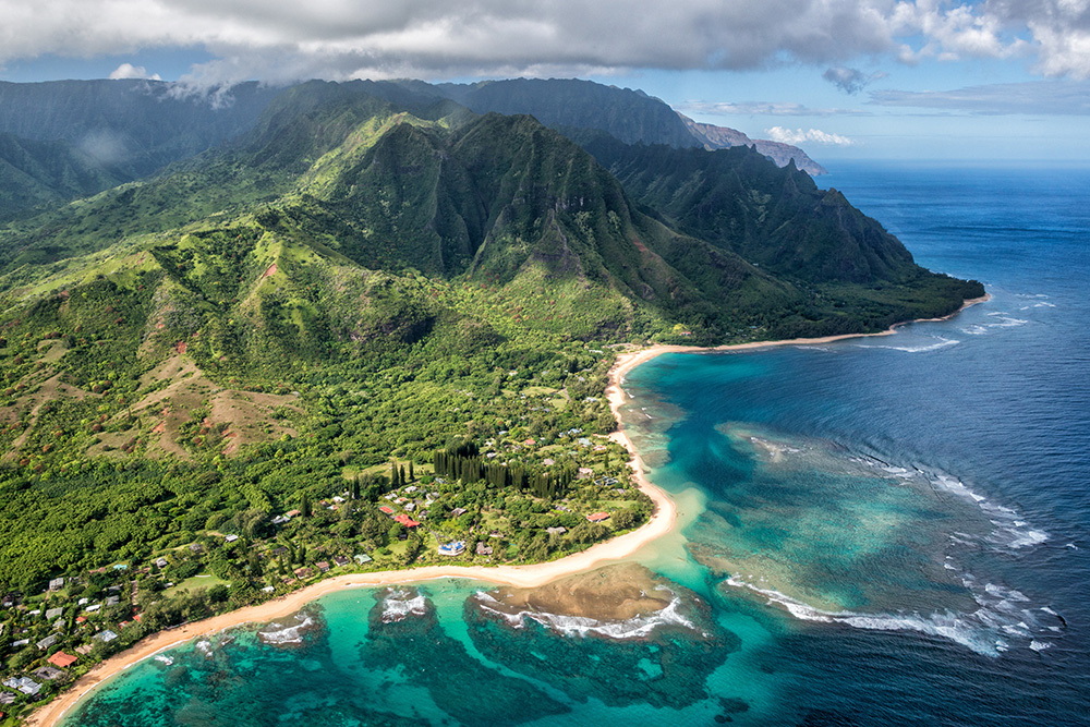
Tunnels on Kauai. Note the canyons carved by five millions years of erosion
In Hawaiian lore Pele, the fiery goddess of volcanoes, originally lived on Kauai, but Namakaokahai, goddess of the sea, attacked her. Pele fled to Oahu but was again forced to flee to Maui. Finally Pele escaped to Hawaii and made her home in Halemaumau Crater at the summit of Kilauea Volcano. The Hawaiian people had correctly worked out that the islands become progressively older to the North West. And that each island had similar volcanic origins to the Big Island.
The volcanic rocks of Kauai were erupted about 5 million years ago and the island is deeply eroded, whereas the Big Island is less than 250,000 years old and new lava is adding to the island daily. This long succession of increasing age with distance from Hawaii is clear evidence that the Pacific Plate has passed over a ‘hot spot’ where a plume of superheated mantle has acted like an acetylene torch, blasting molten magma through the oceanic plate as it passed over.
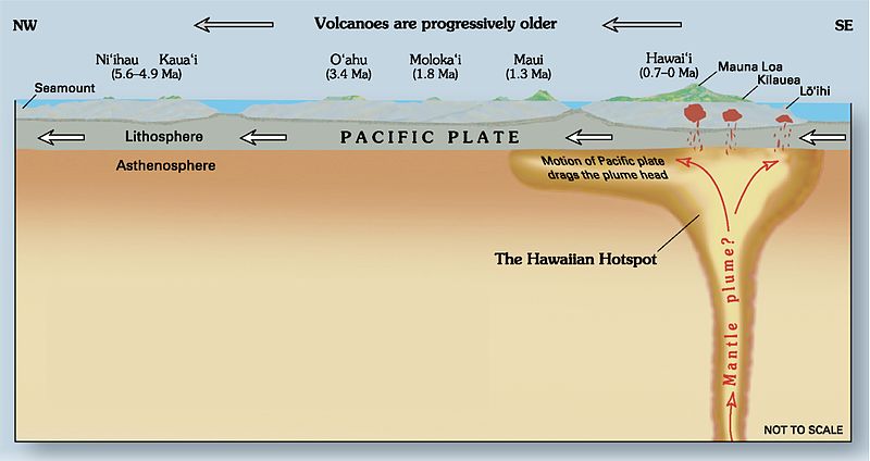
The Hawaiian hot spot shown in cross-section. Diagram by Joel E. Robinson
As the Pacific Plate passed over the Hawaiian hot spot, lavas built into great pilea, growing from seamounts and eventually emerging as islands. Mauna Loa is the largest volcano on earth both in height and volume. It's over 9,100 metres from the base on the seafloor to the summit of 4,170m above sea level - that's higher than Everest! The Lo’ihi Seamount to the south-east is still growing and may one day become the next island in the chain.
The funny thing about hot spots is they remain in a relatively fixed location above the mantle plume, while the tectonic plates move around like rats on the plastic mantle. This mean that the volcanic rocks they erupt through form an exceptional record of the relative movement of the plates. It's simple to calculate rate and direction of plate movement. For example, 6,000 kilometres in 85 million years equals just over 7 centimetres per year.
Hot spot volcanos are different to island arcs because they are not explosive. The magma has its origins deep in the mantle and is low in silica, which makes it very runny. The lava flows out in long rivers, or ropy flows called Pahoehoe. Alternatively, jagged piles of red hot rock clinker solidify to be called a’a! Maybe that's the sound you make when you try and walk on it? The volcano formed is a broad and massive shield of basalt lava and volcanic ash. This is very different to the island arc volcanics that contain considerable silica. Island arc volcanics are typically formed when thick and highly viscous magma becomes explosive as dissolved gasses expand. This leads to steep sided cone shaped volcanos that can sometimes blow their top, like Krakatoa, Mt St Helens, or Pintatubo.
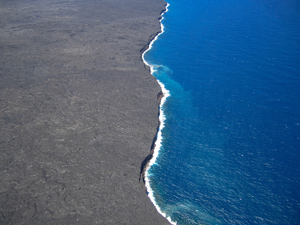
Where lava fields meet the sea...and creates new coastlines! Big Island, Hawaii
What does all this mean for surfers? Firstly, hot spots create great islands, sometimes in the middle of deep ocean basins. This means that you can get an island that is a broad shield shape, but lacks a continental shelf. In the case of the Hawaiian Islands this results in outstanding bathymetry and exposure to swell. However, in the case of the Hawaiian Islands the seamount runs north-west, the same general direction as the prevailing swell, meaning many islands are shadowed.
Secondly, the shield volcanoes are comprised of long tongues of basalt lava rock, interbedded with volcanic ash. In some locations these make for ideal lozenge-shaped convex reefs at a good peel angle to prevailing swells (See Coastal Creationism 2.
Thirdly, hot spot volcanic islands subside over time. The incredible weight of extruded rock actually pushes down the oceanic crust as it floats over the plastic mantle. At the same time, wind, waves, and rain erode the island above the surface carving it back to steep sided ridges. At tropical latitudes, coral reefs grow towards the light creating fringing reefs that progress to barrier reefs as the island sinks further. Ultimately the island itself all but disappears, leaving just the reefs forming an atoll (see Coastal Creationism 7 and 8).
Hot spots are responsible for some of our favourite islands such as the Society Islands, Samoa, The Azores, Canary Islands, and closer to home, Lord Howe Island. All of these islands illustrate the delicate interplay between island subsidence, island erosion, coral reef growth, and surf potential. In my own surf travels I have noticed that younger hot spot islands with high volcanic mountains in the trade wind belt also get the benefits of incredible rainfall. I believe that strong runoff contributes to creating interesting fringing and barrier reefs. Consider the list that fits this description: Hawaii, Tahiti, Pohnpei, Samoa - of course none of these islands has ever had a decent wave break on their reefs! //CHRIS BUYKX
Coastal Creationism is an ongoing series written by Chris Buykx. Chris is a geologist, traveller and lifelong surfer. Specialising in eco-tourism, his passion is interpreting nature and the environment. Chris is a resident of Sydney’s Northern Beaches.
Click here to visit every instalment in the Coastal Creationism series.
Comments
Photographer Greg Button just hiked into the lava flow on the Big Island of Hawaii.
"The lava was still flowing into the ocean making various levels of shoreline. It makes fascinating viewing as the earth creates itself."
"The heat was like a blast furnace and I did have Madame Pele [Hawaiian Fire Godess] stuck to my boots."
Epic. This is high on my list of must-see experiences in life.