Good southerly swell mid-late week
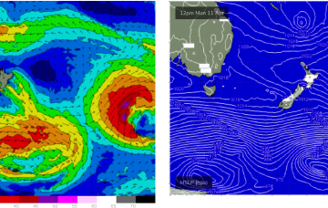
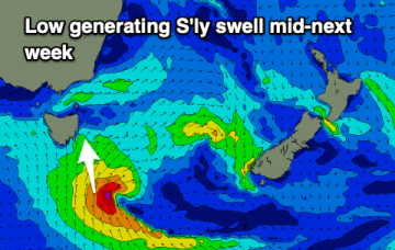
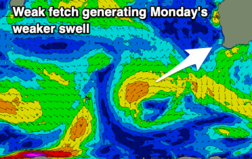
A fun S'ly swell is due through this week, with a reinforcing SE pulse into the end of the week opening up plenty of options.
A large cradling fetch of E to SE winds south of the cyclone is better aimed at sub-tropical areas but should still produce some swell for the East Coast of Tasmania early next week.
A depression just to the North-West of New Caledonia now has a high chance of forming a tropical cyclone (Fili) with this system expected to supply some pulses of swell from the NE to E quadrant as it tracks into the Coral Sea.
A depression just to the North-West of New Caledonia now has a high chance of forming a tropical cyclone (Fili) with this system expected to supply some pulses of swell from the NE to E quadrant as it tracks into the Coral Sea. A large cradling fetch of E to SE winds is also aimed at sub-tropical areas and should produce plenty of swell for the region this week.
Nothing overly large but fun swell pulses with varying and workable winds.
It's a classic "Summer" looking synoptic pattern and indicative of the La Nina pattern hanging on.
Small, weaker swells with favourable winds for the Mid Coast, less so for the Victor region.
Nothing to major swell wise and with deteriorating winds this week, funner on the weekend.
Nothing to recommend over the coming period besides possibly Wednesday. Try the East Coast notes.
No standout days with dicey winds when any swell arrives.